RSS feed source: Volcano Discovery.com--Global earthquake monitor

27 km (17 mi)

S of epicenter

Santa Monica

(pop: 2,280)

III: Weak

Province of Surigao del Norte, Caraga 44 km (28 mi)

S of epicenter

Pilar

(pop: 2,390)

III: Weak

Province of Surigao del Norte, Caraga 44 km (28 mi)

S of epicenter

Del Carmen, Surigao del Norte

(pop: 4,280)

III: Weak

Province of Surigao del Norte, Caraga 53 km (33 mi)

W of epicenter

Loreto

(pop: 5,400)

III: Weak

56 km (35 mi)

S of epicenter

Dapa

(pop: 8,820)

III: Weak

Province of Surigao del Norte, Caraga 56 km (35 mi)

SW of epicenter

Cagdianao

(pop: 2,680)

III: Weak

Dinagat Islands, Caraga 68 km (42 mi)

SW of epicenter

Talisay

(pop: 2,200)

III: Weak

Province of Surigao del Norte, Caraga 72 km (45 mi)

S of epicenter

Socorro

(pop: 9,740)

III: Weak

Province of Surigao del Norte, Caraga 79 km (49 mi)

N of epicenter

Sulangan

(pop: 3,030)

III: Weak

Province of Eastern Samar, Eastern Visayas 80 km (50 mi)

SW of epicenter

Surigao

(pop: 87,800)

III: Weak

Caraga 83 km (52 mi)

SW of epicenter

Placer

(pop: 10,400)

III: Weak

Province of Surigao del Norte, Caraga 84 km (52 mi)

SW of epicenter

Claver

(pop: 5,910)

III: Weak

Province of Surigao del Norte, Caraga 88 km

Click this link to continue reading the article on the source website.

RSS feed source: Volcano Discovery.com--Global earthquake monitor

36 km (22 mi)

S of epicenter

Santa Monica

(pop: 2,280)

III: Weak

Province of Surigao del Norte, Caraga 53 km (33 mi)

S of epicenter

Pilar

(pop: 2,390)

III: Weak

Province of Surigao del Norte, Caraga 54 km (34 mi)

S of epicenter

Del Carmen, Surigao del Norte

(pop: 4,280)

III: Weak

Province of Surigao del Norte, Caraga 57 km (35 mi)

W of epicenter

Loreto

(pop: 5,400)

III: Weak

65 km (40 mi)

S of epicenter

Dapa

(pop: 8,820)

III: Weak

Province of Surigao del Norte, Caraga 66 km (41 mi)

SW of epicenter

Cagdianao

(pop: 2,680)

III: Weak

Dinagat Islands, Caraga 72 km (45 mi)

NW of epicenter

Sulangan

(pop: 3,030)

III: Weak

Province of Eastern Samar, Eastern Visayas 78 km (48 mi)

SW of epicenter

Talisay

(pop: 2,200)

III: Weak

Province of Surigao del Norte, Caraga 81 km (51 mi)

S of epicenter

Socorro

(pop: 9,740)

III: Weak

Province of Surigao del Norte, Caraga 87 km (54 mi)

NW of epicenter

Guiuan

(pop: 11,000)

III: Weak

Province of Eastern Samar, Eastern Visayas 89 km (56 mi)

SW of epicenter

Surigao

(pop: 87,800)

III: Weak

Caraga 92 km (57 mi)

W of epicenter

Hinundayan

(pop: 2,690)

III: Weak

Province of Southern Leyte, Eastern Visayas 93 km

Click this link to continue reading the article on the source website.

RSS feed source: Volcano Discovery.com--Global earthquake monitor

Wed, 5 Nov 2025, 19:50 | BY: EARTHQUAKEMONITOR

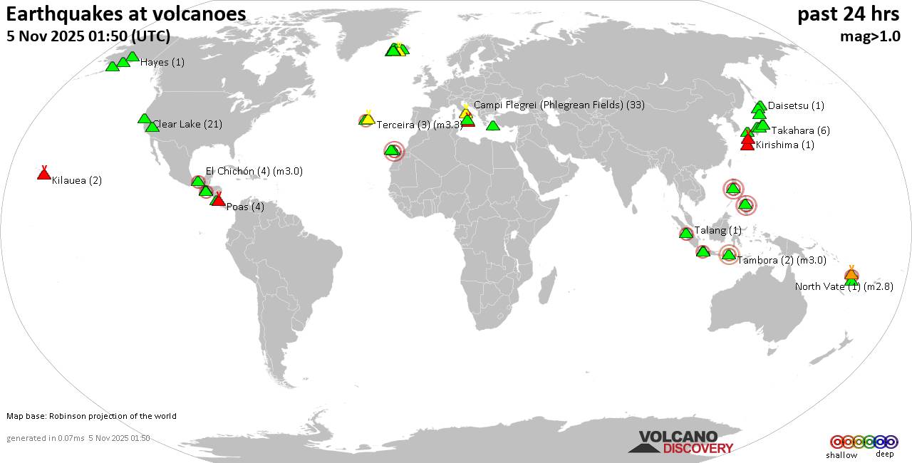
World map showing volcanoes with shallow (less than 50 km) earthquakes within 20 km radius during the past 24 hours on 5 Nov 2025 Number in brackets indicate nr of quakes.

Quakes detected near: Adatara (1 quake mag 1.1), Akuseki-jima (5 quakes between mag 2.0-2.8), Akyarlar (1 quake mag 1.9), Aoba (1 quake mag 2.0), Apaneca Range (26 quakes between mag 1.5-3.0), Askja (3 quakes between mag 0.5-1.5)
Augustine (1 quake mag 1.7), Campi Flegrei (Phlegrean Fields) (27 quakes between mag 0.1-1.8), Canlaon (1 quake mag 1.9), Cayambe (1 quake mag 2.0), Chiginagak (1 quake mag 1.9), Clear Lake (23 quakes between mag 0.7-3.0), Cuernos de Negros (1 quake mag 3.0), Denison (1 quake mag 1.3), El Chichón (22 quakes between mag 1.5-3.0), El Hierro (1 quake mag 2.1), Eldey (5 quakes between mag 0.9-1.7), Erciyes Dagi (1 quake mag 3.0), Gran Canaria (7 quakes between mag 0.4-1.8), Grímsvötn (1 quake mag 1.2), Haku-san (3 quakes between mag 0.2-1.0), Heiðarsporðar (2 quakes between mag 0.1-1.1), Hibok-Hibok (1 quake mag 3.0), Hrómundartindur (1 quake mag 1.2), Izalco (1 quake mag 2.2), Kenger (2 quakes between mag 1.2-1.7), Kilauea (1 quake mag 2.5), Kirishima (4 quakes between mag 0.3-1.3), Kolumbo (9 quakes between mag 0.5-2.2), Komaga-take (1 quake mag 1.0), Krísuvík (14 quakes between mag 0.2-1.6), Kurikoma (8

Click this link to continue reading the article on the source website.
RSS feed source: Volcano Discovery.com--Global earthquake monitor

The University of Nebraska-Lincoln (UNL) Department of Civil and Environmental Engineering (CEE)
invites applications for a tenure-track Assistant Professor position in Structural Engineering with an
anticipated start date in August 2026. Candidates for this position are expected to demonstrate a
strong commitment to teaching excellence at the undergraduate and graduate levels, along with a
proven research capability that will support the development of an externally funded, independent
research program and publication in leading scholarly journals. The successful candidate should also be
prepared to collaborate with colleagues, develop new research efforts, and contribute to ongoing
research initiatives.

This position offers exceptional opportunities for interdisciplinary collaboration and access to
advanced research infrastructure. Facilities within CEE include high-bay structural testing laboratories
on both City Campus in Lincoln and Scott Campus in Omaha. Additional advanced research
infrastructure is available through the Nebraska Transportation Center, the Mid-America
Transportation Center (Region VII University Transportation Center), the Midwest Roadside Safety
Facility, the Nebraska

Click this link to continue reading the article on the source website.