RSS feed source: Volcano Discovery.com--Global earthquake monitor

Mon, 18 Aug 2025, 21:50 | BY: EARTHQUAKEMONITOR

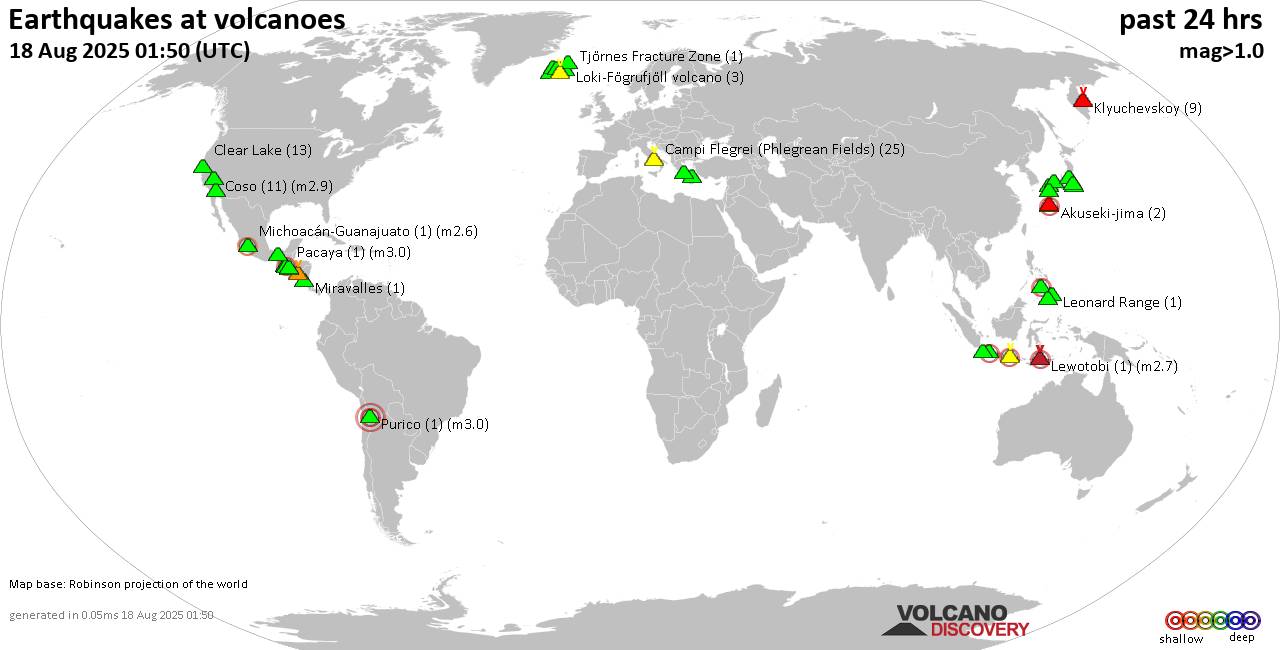
World map showing volcanoes with shallow (less than 50 km) earthquakes within 20 km radius during the past 24 hours on 18 Aug 2025 Number in brackets indicate nr of quakes.

Quakes detected near: Agua (1 quake mag 2.9), Akuseki-jima (3 quakes between mag 1.8-2.3), Brennisteinsfjöll (12 quakes between mag 0.2-1.2), Cabalian (1 quake mag 2.1), Campi Flegrei (Phlegrean Fields) (9 quakes between mag 0.1-1.1), Clear Lake (11 quakes between mag 0.2-1.4)
Coso (16 quakes between mag 0.8-2.8), El Chichón (9 quakes between mag 1.9-2.6), Eldey (3 quakes between mag 0.9-1.5), Etna (1 quake mag 1.2), Galeras (1 quake mag 1.0), Geureudong (1 quake mag 2.1), Grímsvötn (1 quake mag 1.5), Hakone (2 quakes between mag 0.1-2.5), Hengill (2 quakes between mag 1.3-3.2), Hulubelu (1 quake mag 1.3), Ijen (12 quakes between mag 2.4-4.0), Irazu (1 quake mag 1.0), Isarog (1 quake mag 3.0), Izu-Tobu (2 quakes between mag 0.1-1.6), Katla (7 quakes between mag 0.2-2.0), Kenger (1 quake mag 1.7), Kilauea (1 quake mag 1.9), Klyuchevskoy (2 quakes between mag 1.2-1.6), Kolumbo (3 quakes between mag 1.1-2.1), Krísuvík (20 quakes between mag 0.1-1.6), Laacher See (1 quake mag 3.0), Langjökull (1 quake mag 1.3), Ljósufjöll (10 quakes between mag 0.2-2.1), Loki-Fögrufjöll volcano (2 quakes between mag 1.0-1.8), Methana (2 quakes between mag 0.9-1.0), Michoacán-Guanajuato (9

Click this link to continue reading the article on the source website.
RSS feed source: Volcano Discovery.com--Global earthquake monitor

At 548 PM CDT, Doppler radar was tracking strong thunderstorms along a line extending from near Spiritwood to Ypsilanti. Movement was southeast at 15 mph. HAZARD…Wind gusts up to 40 mph and penny size hail. SOURCE…Radar indicated. IMPACT…Gusty winds could knock down tree limbs and blow around unsecured objects. Minor hail damage to vegetation is possible. Locations impacted include… Eastern Jamestown, Ypsilanti, and Spiritwood.

Click this link to continue reading the article on the source website.

RSS feed source: Volcano Discovery.com--Global earthquake monitor

SVROUN The National Weather Service in Norman has issued a * Severe Thunderstorm Warning for… Northwestern Ellis County in northwestern Oklahoma… Southwestern Harper County in northwestern Oklahoma… Southwestern Woodward County in northwestern Oklahoma… * Until 630 PM CDT. * At 546 PM CDT, severe thunderstorms were located along a line extending from 9 miles southeast of Slapout to 7 miles north of Gage, moving northwest at 10 mph. HAZARD…Golf ball size hail and 70 mph wind gusts. SOURCE…Radar indicated. At 636 PM CDT, a 60 mph wind gust was reported at Gage Airport. IMPACT…People and animals outdoors will be injured. Expect hail damage to roofs, siding, windows, and vehicles. Expect considerable

Click this link to continue reading the article on the source website.

RSS feed source: Volcano Discovery.com--Global earthquake monitor

At 447 PM MDT, Doppler radar was tracking a strong thunderstorm 6 miles southwest of Iron Lightning, or 8 miles northeast of Faith, moving east at 10 mph. HAZARD…Wind gusts up to 40 mph and half inch hail. SOURCE…Radar indicated. IMPACT…Gusty winds could knock down tree limbs and blow around unsecured objects. Minor hail damage to vegetation is possible. Locations impacted include… Red Elm and Iron Lightning.

Click this link to continue reading the article on the source website.