RSS feed source: USGS Earthquake Hazards Program
Time2025-10-10 11:47:39 UTC2025-10-10 11:47:39 UTC at epicenterLocation7.253°N 127.150°EDepth41.47 km (25.77 mi)
Click this link to continue reading the article on the source website.
RSS feed source: USGS Earthquake Hazards Program
Time2025-10-10 11:47:39 UTC2025-10-10 11:47:39 UTC at epicenterLocation7.253°N 127.150°EDepth41.47 km (25.77 mi)
Click this link to continue reading the article on the source website.
RSS feed source: USGS Earthquake Hazards Program
Fri, 10 Oct 2025, 11:50 | BY: EARTHQUAKEMONITOR
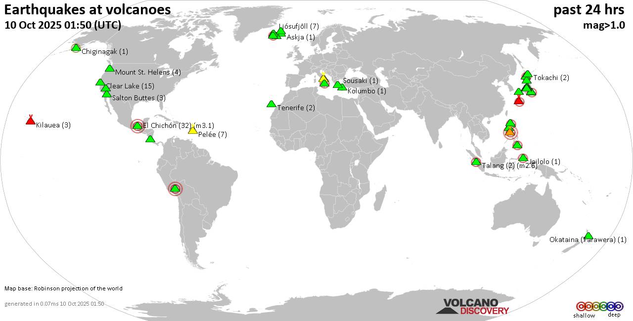
World map showing volcanoes with shallow (less than 50 km) earthquakes within 20 km radius during the past 24 hours on 10 Oct 2025 Number in brackets indicate nr of quakes.
Quakes detected near: Akuseki-jima (1 quake mag 2.0), Askja (1 quake mag 1.2), Brennisteinsfjöll (2 quakes between mag 0.8-1.0), Cagua (1 quake mag 2.6), Calatrava (1 quake mag 3.0), Camiguin de Babuyanes (1 quake mag 2.8)
Campi Flegrei (Phlegrean Fields) (33 quakes between mag 0.1-1.3), Clear Lake (21 quakes between mag 0.2-1.8), Coso (5 quakes between mag 0.8-2.8), Cuilapa-Barbarena (1 quake mag 2.6), El Chichón (43 quakes between mag 1.3-3.1), Esjufjöll (1 quake mag 1.1), Hiuchi (7 quakes between mag 0.2-1.0), Hrómundartindur (1 quake mag 1.2), Imbabura (1 quake mag 2.5), Iriomote-jima (1 quake mag 1.1), Jailolo (1 quake mag 2.3), Kilauea (3 quakes between mag 1.7-1.9), Kolumbo (2 quakes between mag 1.0-1.1), Komaga-take (1 quake mag 1.2), Krísuvík (8 quakes between mag 0.5-2.0), La Palma (1 quake mag 1.6), Ljósufjöll (5 quakes between mag 0.7-1.8), Maunaloa (1 quake mag 1.7), Nasu (1 quake mag 1.1), Nigorigawa (4 quakes between mag 1.1-2.6), Nii-jima (1 quake mag 1.0), Norikura (2 quakes between mag 0.7-1.3), Okataina (Tarawera) (1 quake mag 1.5), Ontake-san (3 quakes between mag 0.2-2.9), Pelée (3 quakes between mag 0.7-1.0), Pico (1 quake mag
Click this link to continue reading the article on the source website.
RSS feed source: USGS Earthquake Hazards Program
Date and TimeMag
DepthDistanceLocationDetailsMap Oct 10, 07:43 pm (GMT +10)
5.6
10 km21 km (13 mi) to the S Philippine Sea, 410 km southwest of Guam Island, Guam I FELT IT InfoSep 27, 12:48 am (GMT +10)
4.9
46 km96 km (60 mi) to the W 208 km N of Fais, Micronesia InfoSep 25, 05:42 pm (GMT +9)
5.1
65 km40 km (25 mi) to the E 257 km NE of Fais, Micronesia InfoSep 22, 12:59 pm (GMT +9)
5.0
13 km75 km (46 mi) to the NE South of the Mariana Islands InfoSep 4, 01:37 pm (GMT +9)
5.1
10 km28 km (18 mi) to the E 258 km NE of Fais, Micronesia InfoMay 5, 2024 04:44 pm (GMT +11)
5.5
45 km84 km (52 mi) to the S 156 km NE of Fais, Micronesia InfoDec 23, 2019 05:33 pm (GMT +11)
5.8
39 km20 km (12 mi) to the SE Philippine Sea, 405 km southwest of Dededo Village, Dededo, Guam 1 reportInfoOct 7, 2013 01:38 am (GMT +9)
6.0
104 km75 km (47 mi) to the N Mariana Islands Region 3 reportsInfoAug 19, 2010 01:28 am (GMT +9)
6.3
10 km67 km (42 mi) to the N Philippine Sea, 376 km west of Guam Island, Guam InfoAug 14, 2010 11:01 pm (Universal Time)
5.8
33 km73 km (45 mi) to the N South of Mariana Islands InfoAug 15, 2010 08:01 am (GMT +9)
6.6
13 km74 km (46 mi) to the N 294 km NNE of Fais, Micronesia InfoAug 14, 2010 04:31 pm (GMT +9)
5.7
10 km86 km (53 mi) to the N Mariana Islands Region InfoAug 14, 2010 04:30 pm (GMT +9)
6.2
10 km80 km (50 mi) to the N Philippine Sea, 374
Click this link to continue reading the article on the source website.
RSS feed source: USGS Earthquake Hazards Program
Date and TimeMag
DepthDistanceLocationDetailsMap Oct 10, 11:12 am (Universal Time)
6.7
61 km44 km (28 mi) to the W Philippine Sea, 24 km east of Manay, Philippines I FELT IT – 151 reportsInfoOct 10, 07:08 pm (GMT +8)
4.5
43 km34 km (21 mi) to the NE Philippine Sea, 93 km east of Manay, Philippines I FELT IT – 1 reportInfoOct 10, 07:00 pm (GMT +8)
4.2
10 km31 km (19 mi) to the N Philippine Sea, 86 km northeast of Manay, Philippines I FELT IT – 10 reportsInfoOct 10, 10:20 am (Universal Time)
5.1
70 km45 km (28 mi) to the W 25 km ESE of Manay, Philippines I FELT IT – 5 reportsInfoOct 10, 10:01 am (Universal Time)
5.1
82 km31 km (19 mi) to the W Philippine Sea, 37 km east of Manay, Philippines I FELT IT – 2 reportsInfoOct 10, 09:43 am (Universal Time)
5.2
73 km40 km (25 mi) to the SW Philippine Sea, 46 km southeast of Manay, Philippines I FELT IT InfoOct 10, 07:24 am (Universal Time)
5.2
74 km43 km (27 mi) to the SW Philippine Sea, 41 km southeast of Manay, Philippines I FELT IT InfoOct 10, 01:43 am (Universal Time)
7.4
58 km44 km (27 mi) to the W Philippine Sea, 24 km east of Manay, Philippines I FELT IT – 364 reportsInfoDec 2, 2023 10:37 pm (Manila)
7.6
40 km163 km (101 mi) to the NW Philippine Sea, 36 km north of Bislig, Philippines 565 reportsInfoAug 11, 2021 05:46 pm (GMT +0)
7.0
63 km97 km (60 mi) to the SW Mindanao, Philippines 617 reportsInfoSep 8, 2018 03:16 pm (Manila)
6.1
10 km63 km (39 mi) to
Click this link to continue reading the article on the source website.