RSS feed source: Global Disaster Alert and Coordination Systems (GDACS).
The Drought alert level is Green.
Click this link to continue reading the article on the source website.
RSS feed source: Global Disaster Alert and Coordination Systems (GDACS).
The Drought alert level is Green.
Click this link to continue reading the article on the source website.
RSS feed source: Global Disaster Alert and Coordination Systems (GDACS).
Date and TimeMag
DepthDistanceLocationDetailsMap Aug 24, 11:40 pm (GMT -6)
4.0
16 km80 km (50 mi) to the N North Pacific Ocean, 90 km southeast of Salina Cruz, Estado de Oaxaca, Mexico I FELT IT InfoAug 24, 05:26 pm (GMT -6)
4.1
16 km69 km (43 mi) to the SE North Pacific Ocean, Mexico I FELT IT InfoAug 24, 04:29 pm (GMT -6)
4.0
16 km99 km (62 mi) to the E North Pacific Ocean, 152 km south of Tonala, Estado de Chiapas, Mexico I FELT IT InfoAug 24, 04:28 pm (GMT -6)
4.0
15 km89 km (56 mi) to the E North Pacific Ocean, 146 km south of Tonala, Estado de Chiapas, Mexico I FELT IT InfoAug 23, 04:55 pm (GMT -6)
4.1
16 km48 km (30 mi) to the E North Pacific Ocean, 168 km southwest of Pijijiapan, Estado de Chiapas, Mexico I FELT IT InfoAug 23, 08:14 am (GMT -6)
4.4
12 km45 km (28 mi) to the SE North Pacific Ocean, 177 km southwest of Pijijiapan, Estado de Chiapas, Mexico I FELT IT InfoAug 20, 10:10 pm (GMT -6)
4.2
16 km32 km (20 mi) to the E North Pacific Ocean, 173 km southeast of Salina Cruz, Estado de Oaxaca, Mexico I FELT IT InfoAug 20, 09:49 pm (GMT -6)
4.4
15 km27 km (16 mi) to the E North Pacific Ocean, 175 km southwest of Tonala, Estado de Chiapas, Mexico I FELT IT InfoAug 10, 08:21 pm (GMT -6)
5.8
9.1 km38 km (23 mi) to the E North Pacific Ocean, 250 km southwest of Tuxtla, Estado de Chiapas, Mexico 1 reportInfoJun 18,
Click this link to continue reading the article on the source website.
RSS feed source: Global Disaster Alert and Coordination Systems (GDACS).
Support Us – Help Us Enhance Our Services! We’re passionate about delivering the latest volcano and earthquake data from around the globe — just for you. However, maintaining our website and free apps requires significant time, effort, and resources.
Your support helps us expand our hardware and software capabilities and empowers our dedicated editorial team. Our mission is to provide uninterrupted, real-time updates whenever an earthquake strikes or a volcano erupts — and your donations make this possible. Every contribution, big or small, is deeply appreciated. If you find our information valuable and want to help us add new features, create compelling content, and improve our technology, please consider making a donation: Donate with Card or Apple/Google Pay: Donate with PayPal: Planned Features: Improved multilingual support Tsunami alerts Faster responsiveness Thanks to your past donations, we have recently
Click this link to continue reading the article on the source website.
RSS feed source: Global Disaster Alert and Coordination Systems (GDACS).
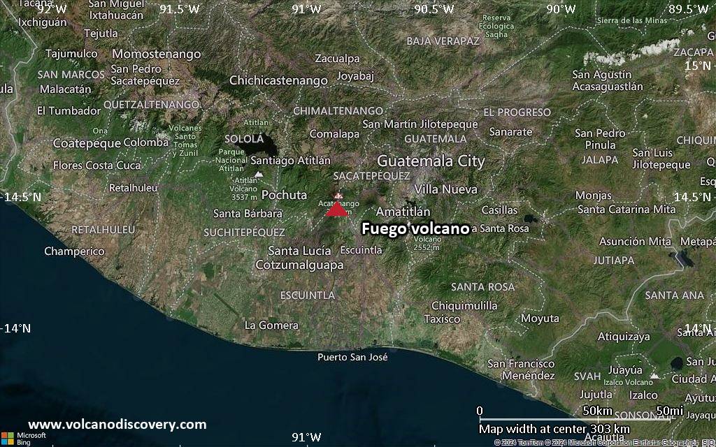
<!–div style="font-size:14px;text-align:center;border:3px solid blue;border-radius:5px;padding:3px;margin:5px;background:#eee"><a href="https://www.volcanoesandearthquakes.com/app/volcano-report.php?volcanoId=26" style="text-decoration:none" target="_blank" rel="noopener noreferrer nofollow" title="Share a volcano (activity) report, submit a photo or other interesting news!” onclick=”window.open(this.href,’Volcano Report’,’status=0,toolbar=0,location=0,directories=0,menubar=0,resizable=1,scrollbars=1,height=500,width=450′);return false”>Send Volcano Report</div–> Stratovolcano 3,763 m / 12,346 ft
Guatemala, 14.47°N / -90.88°W
Current status: erupting (4 out of 5) Fuego volcano eruptions:
1581, 1585, 1586, 1587, 1614, 1617, 1620, 1623, 1629, 1679(?), 1685, 1686, 1689(?), 1699, 1702, 1705, 1706, 1709(?), 1710,1717,1730, 1732, 1737, 1751(?), 1765(?), 1773(?), 1799, 1826, 1829, 1850(?), 1852(?), 1855, 1856, 1857, 1860, 1861(?), 1867(?), 1880, 1896, 1932, 1944, 1949, 1953, 1955, 1957, 1962, 1963, 1966, 1967, 1971, 1973, 1974, 1975, 1977, 1987, 1999, 2002 – ongoing
Typical eruption style
Dominantly explosive, construction of lava domes and extrusion of viscous lava flows. In near constant activity, at least during the past centuries.
Click this link to continue reading the article on the source website.