RSS feed source: USGS Earthquake Hazards Program
Time2025-08-18 08:30:49 UTC2025-08-18 08:30:49 UTC at epicenterLocation3.154°N 124.386°EDepth325.32 km (202.14 mi)
Click this link to continue reading the article on the source website.
RSS feed source: USGS Earthquake Hazards Program
Time2025-08-18 08:30:49 UTC2025-08-18 08:30:49 UTC at epicenterLocation3.154°N 124.386°EDepth325.32 km (202.14 mi)
Click this link to continue reading the article on the source website.
RSS feed source: USGS Earthquake Hazards Program
Date and TimeMag
DepthDistanceLocationDetailsMap Aug 4, 03:46 pm (GMT +8)
4.1
290 km27 km (17 mi) to the S Celebes Sea InfoJul 19, 09:34 pm (GMT +8)
4.0
250 km60 km (37 mi) to the SE 450 km northeast of Luwuk, Kabupaten Banggai, Sulawesi Tengah, Indonesia InfoJun 24, 03:11 am (GMT +8)
4.2
369 km82 km (51 mi) to the SW Celebes Sea InfoApr 26, 06:25 pm (GMT +8)
4.2
349 km20 km (12 mi) to the NW Celebes Sea InfoJun 30, 2024 02:24 pm (GMT +8)
4.0
320 km40 km (25 mi) to the N223 km NNW of Manado, Indonesia InfoNov 6, 2022 08:03 am (GMT +8)
6.1
255 km81 km (50 mi) to the SE Celebes Sea, 109 km north of Manado, Kota Manado, Sulawesi Utara, Indonesia 2 reportsInfoNov 25, 2021 11:56 am (GMT +8)
4.7
380 km42 km (26 mi) to the NW 217 km NNW of Manado, Indonesia InfoNov 17, 2021 05:07 am (GMT +8)
4.7
126 km75 km (47 mi) to the N Indonesia: Celebes Sea InfoDec 29, 2019 02:34 pm (GMT +8)
4.7
393 km69 km (43 mi) to the W Celebes Sea (Indonesia) InfoNov 15, 2019 01:17 am (Jayapura)
7.0
27 km270 km (168 mi) to the SE Maluku Sea, North Maluku, 131 km east of Bitung, Sulawesi Utara, Indonesia 95 reportsInfoDec 1, 2018 04:07 am (GMT +8)
4.7
338 km81 km (51 mi) to the SW Celebes Sea 1 reportInfoSep 8, 2018 04:44 am (Makassar)
5.3
198 km74 km (46 mi) to the SE Celebes Sea 1 reportInfoMay 8, 2017 04:33 pm (GMT +8)
4.8
293 km30 km (19 mi) to the E Celebes Sea InfoJan 10, 2017 02:13 pm (GMT +8)
7.2
633 km257 km (160 mi) to the NW Celebes Sea, 249 km
Click this link to continue reading the article on the source website.
RSS feed source: USGS Earthquake Hazards Program
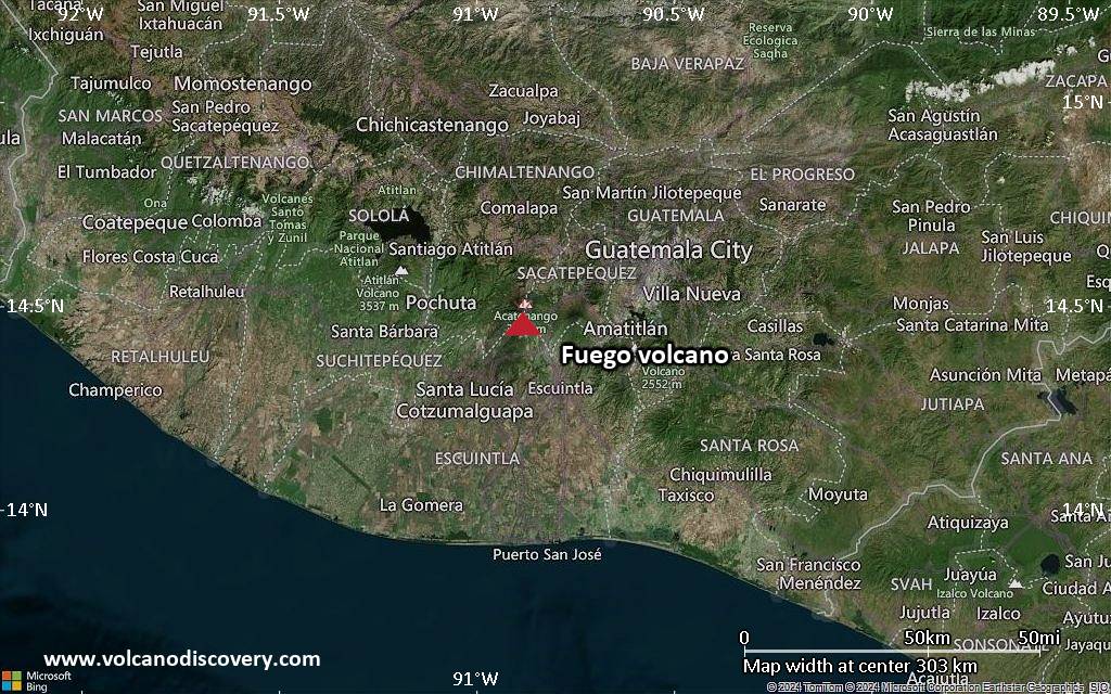
<!–div style="font-size:14px;text-align:center;border:3px solid blue;border-radius:5px;padding:3px;margin:5px;background:#eee"><a href="https://www.volcanoesandearthquakes.com/app/volcano-report.php?volcanoId=26" style="text-decoration:none" target="_blank" rel="noopener noreferrer nofollow" title="Share a volcano (activity) report, submit a photo or other interesting news!” onclick=”window.open(this.href,’Volcano Report’,’status=0,toolbar=0,location=0,directories=0,menubar=0,resizable=1,scrollbars=1,height=500,width=450′);return false”>Send Volcano Report</div–> Stratovolcano 3,763 m / 12,346 ft
Guatemala, 14.47°N / -90.88°W
Current status: erupting (4 out of 5) Fuego volcano eruptions:
1581, 1585, 1586, 1587, 1614, 1617, 1620, 1623, 1629, 1679(?), 1685, 1686, 1689(?), 1699, 1702, 1705, 1706, 1709(?), 1710,1717,1730, 1732, 1737, 1751(?), 1765(?), 1773(?), 1799, 1826, 1829, 1850(?), 1852(?), 1855, 1856, 1857, 1860, 1861(?), 1867(?), 1880, 1896, 1932, 1944, 1949, 1953, 1955, 1957, 1962, 1963, 1966, 1967, 1971, 1973, 1974, 1975, 1977, 1987, 1999, 2002 – ongoing
Typical eruption style
Dominantly explosive, construction of lava domes and extrusion of viscous lava flows. In near constant activity, at least during the past centuries.
Click this link to continue reading the article on the source website.
RSS feed source: USGS Earthquake Hazards Program
PAGER – GREEN ShakeMap – IV DYFI? – III
Time2025-08-18 07:48:43 UTC2025-08-18 07:48:43 UTC at epicenterLocation15.286°S 173.344°WDepth10.00 km (6.21 mi)
Click this link to continue reading the article on the source website.