RSS feed source: Volcano Discovery.com--Global earthquake monitor

Date and TimeMag
DepthDistanceLocationDetailsMap Sep 1, 02:03 am (GMT +4:30)

5.2

10 km13 km (8.4 mi) to the N 44 km southwest of Asadabad, Kunar, AfghanistanI FELT IT2 reportsInfoSep 1, 12:59 am (GMT +4:30)

4.5

10 km22 km (14 mi) to the NE 31 km southwest of Asadabad, Kunar, AfghanistanI FELT IT InfoSep 1, 12:08 am (GMT +4:30)

4.5

10 km33 km (20 mi) to the SE 41 km east of Jalalabad, Nangarhar, AfghanistanI FELT IT2 reportsInfoAug 31, 11:47 pm (GMT +4:30)

6.0

8 km8.6 km (5.3 mi) to the SE Nangarhar, 55 km southwest of Asadabad, Kunar, AfghanistanI FELT IT126 reportsInfoMay 9, 01:22 am (GMT +4:30)

4.3

10 km88 km (55 mi) to the NE Nuristan, 45 km north of Asadabad, Kunar, Afghanistan InfoJun 19, 2024 08:47 am (GMT +4:30)

4.8

70 km55 km (34 mi) to the NW 25 km north of Mehtar Lam, Laghman, Afghanistan 17 reportsInfoJan 19, 2023 04:00 pm (GMT +4:30)

5.1

104 km124 km (77 mi) to the NE Nuristan, 78 km north of Asadabad, Kunar, Afghanistan 36 reportsInfoSep 5, 2022 02:27 am (GMT +4:30)

5.1

10 km8.5 km (5.3 mi) to the N 35 km NE of Jal?l?b?d, Afghanistan 79 reportsInfoAug 5, 2021 06:56 am (Karachi)

4.7

10 km114 km (71 mi) to the NE 182km NW of Islamabad, Pakistan InfoOct 26, 2015 01:39 pm (GMT +4:30)

7.5

207 km211 km (131 mi) to the N 77 km southeast of Fayzabad, Badakhshan, Afghanistan InfoApr 24, 2013 09:25 am (Universal Time)

5.3

63 km44 km (28 mi) to the W Southeastern Afghanistan InfoApr 24, 2013 01:55 pm (GMT +4:30)

5.5

64 km44 km (27 mi) to the

Click this link to continue reading the article on the source website.

RSS feed source: Volcano Discovery.com--Global earthquake monitor

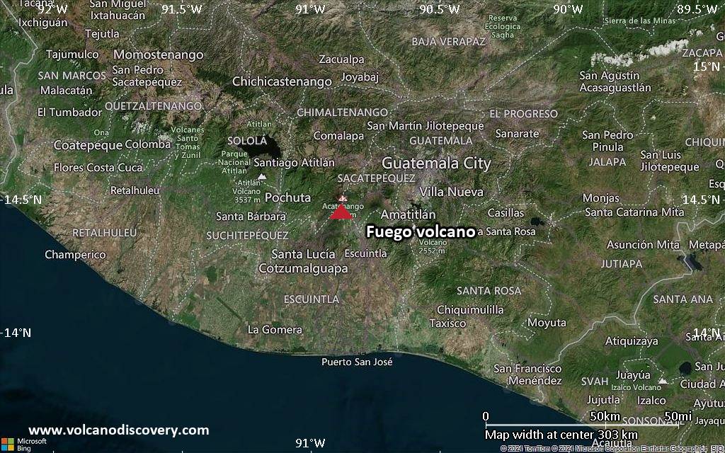
<!–div style="font-size:14px;text-align:center;border:3px solid blue;border-radius:5px;padding:3px;margin:5px;background:#eee"><a href="https://www.volcanoesandearthquakes.com/app/volcano-report.php?volcanoId=26" style="text-decoration:none" target="_blank" rel="noopener noreferrer nofollow" title="Share a volcano (activity) report, submit a photo or other interesting news!” onclick=”window.open(this.href,’Volcano Report’,’status=0,toolbar=0,location=0,directories=0,menubar=0,resizable=1,scrollbars=1,height=500,width=450′);return false”>Send Volcano Report</div–> Stratovolcano 3,763 m / 12,346 ft
Guatemala, 14.47°N / -90.88°W
Current status: erupting (4 out of 5) Fuego volcano eruptions:
1581, 1585, 1586, 1587, 1614, 1617, 1620, 1623, 1629, 1679(?), 1685, 1686, 1689(?), 1699, 1702, 1705, 1706, 1709(?), 1710,1717,1730, 1732, 1737, 1751(?), 1765(?), 1773(?), 1799, 1826, 1829, 1850(?), 1852(?), 1855, 1856, 1857, 1860, 1861(?), 1867(?), 1880, 1896, 1932, 1944, 1949, 1953, 1955, 1957, 1962, 1963, 1966, 1967, 1971, 1973, 1974, 1975, 1977, 1987, 1999, 2002 – ongoing
Typical eruption style
Dominantly explosive, construction of lava domes and extrusion of viscous lava flows. In near constant activity, at least during the past centuries.

Click this link to continue reading the article on the source website.
RSS feed source: Volcano Discovery.com--Global earthquake monitor

Date and TimeMag
DepthDistanceLocationDetailsMap Aug 13, 08:32 am (Jakarta)

4.8

32 km87 km (54 mi) to the NW Indian Ocean, 61 km southwest of Banjar, Indonesia 7 reportsInfoJul 19, 06:25 pm (GMT +7)

4.3

24 km33 km (21 mi) to the NE Indian Ocean, 92 km southwest of Tasikmalaya, Indonesia InfoJun 23, 07:56 am (GMT +7)

4.9

10 km61 km (38 mi) to the W Indian Ocean, 124 km south of Banjar, Kabupaten Bandung, Jawa Barat, Indonesia InfoJun 21, 12:53 pm (GMT +7)

4.6

29 km69 km (43 mi) to the E Java, Indonesia 2 reportsInfoJun 18, 03:24 pm (GMT +7)

4.8

10 km40 km (25 mi) to the W Indian Ocean, 149 km south of Bandung, Kota Bandung, Jawa Barat, Indonesia 2 reportsInfoJun 15, 11:31 pm (GMT +7)

4.8

24 km11 km (6.9 mi) to the N Indian Ocean, 138 km south of Bandung, Kota Bandung, Jawa Barat, Indonesia 1 reportInfoApr 22, 05:14 pm (GMT +7)

5.7

35 km96 km (60 mi) to the W Indian Ocean, 231 km south of Jakarta, Daerah Khusus Ibukota Jakarta, Indonesia 6 reportsInfoApr 27, 2024 11:29 pm (GMT +7)

6.5

10 km45 km (28 mi) to the SW Indian Ocean, Jawa Barat, 249 km south of Jakarta, Indonesia 369 reportsInfoOct 19, 2023 09:08 pm (GMT +7)

5.6

18 km38 km (24 mi) to the NW Indian Ocean, 100 km south of Banjar, Kabupaten Bandung, Jawa Barat, Indonesia 9 reportsInfoDec 3, 2022 04:49 pm (Jakarta)

6.4

118 km84 km (52 mi) to the N Indonesia: Di Darat 52 Km BaratDaya Kab-Garut 42 reportsInfoDec 15, 2017 11:47 pm (Jakarta)

6.4

109 km84 km (52 mi) to the NE Kabupaten Tasikmalaya, 40 km south

Click this link to continue reading the article on the source website.

RSS feed source: Volcano Discovery.com--Global earthquake monitor

Sun, 31 Aug 2025, 21:20 | BY: EARTHQUAKEMONITOR

Worldwide earthquakes above magnitude 3 during the past 24 hours on 31 Aug 2025

Summary: 1 quake 6.0+, 3 quakes 5.0+, 47 quakes 4.0+, 124 quakes 3.0+, 316 quakes 2.0+ (491 total)
This report is being updated every hour.
Magnitude 6+: 1 earthquake
Magnitude 5+: 3 earthquakes
Magnitude 4+: 47 earthquakes
Magnitude 3+: 124 earthquakes
Magnitude 2+: 316 earthquakes
No quakes of magnitude 7 or higherTotal seismic energy estimate: 1.3 x 10¹⁴ joules (36.8 gigawatt hours, equivalent to 31687 tons of TNT or 2 atomic bombs!) | equivalent to ONE quake of magnitude 6.2 learn more10 largest earthquakes in the world (past 24 hours)#1: Mag 6.0 Nangarhar, 55 km southwest of Asadabad, Kunar, AfghanistanSunday, Aug 31, 2025, at 11:47 pm (GMT +4:30) – #2: Mag 5.9 South Atlantic Ocean, 43 km east of Montagu Island, South Georgia and the South Sandwich IslandsSunday, Aug 31, 2025, at 02:24 pm (GMT -2) – #3: Mag 5.1 Southern Mid-Atlantic RidgeSunday, Aug 31, 2025, at 02:50 am (GMT -1) – #4: Mag 5.1 Banda Sea, 67 km north of Pulau Molu Island, Maluku, IndonesiaSunday, Aug 31, 2025, at 08:03 am (GMT +9) – #5: Mag 4.9 South Pacific Ocean, 169 km east of Ambitle Island, Papua New GuineaSunday, Aug 31, 2025, at 09:58 pm (GMT +11) – #6: Mag 4.9 46 km northeast of Lae, Morobe Province,

Click this link to continue reading the article on the source website.