RSS feed source: Volcano Discovery.com--Global earthquake monitor

Fri, 3 Oct 2025, 06:16 | BY: EARTHQUAKEMONITOR

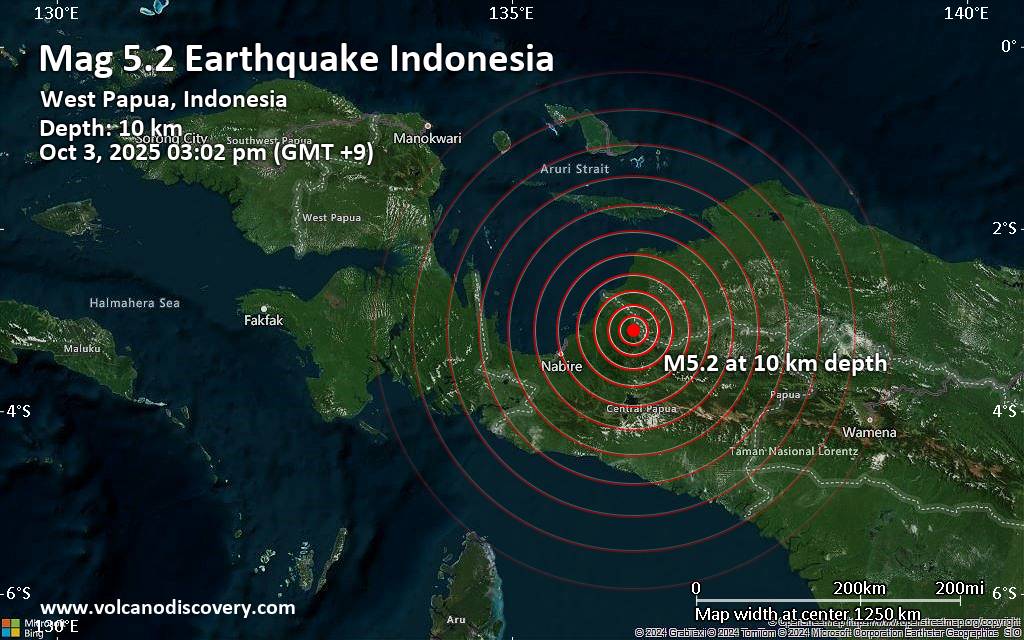
Just 12 minutes ago, a 5.2-magnitude earthquake struck near Nabire, Nabire Regency, Central Papua, Indonesia. The tremor was recorded early afternoon on Friday, October 3rd, 2025, at 3:02 pm local time, at a shallow depth of 10. km below the surface.
The event was filed by the German Research Centre for Geosciences (GFZ), the first seismological agency to report it.
Based on the preliminary seismic data, the quake should not have caused any significant damage, but was probably felt by many people as light vibration in the area of the epicenter.
Weak shaking might have been felt in Nabire (pop. 43,900) located 97 km from the epicenter.
VolcanoDiscovery will automatically update magnitude and depth if these change and follow up if other significant news about the quake become available. If you’re in the area, please send us your experience through our reporting mechanism, either online or via our mobile app. This will help us provide more first-hand updates to anyone around the globe who wants to know more about this quake.

If you felt it, report it through our site or app right now!

Download and Upgrade the Volcanoes & Earthquakes app to get one of the fastest seismic alerts online:
Android | IOS
Earthquake data:

I felt this quake

Date & time: Oct 3, 2025 03:02 pm (GMT +9) local time (3

Click this link to continue reading the article on the source website.

RSS feed source: Volcano Discovery.com--Global earthquake monitor

At 1112 PM PDT, Doppler radar was tracking a strong thunderstorm 28 miles southeast of Oakhurst, or 34 miles west of Aspendell, moving northeast at 15 mph. HAZARD…Pea size hail. SOURCE…Radar indicated. IMPACT…Minor hail damage to vegetation is possible. Locations impacted include… Tamarack Summit, Shaver Lake 3ne, and Shaver Lake.

Click this link to continue reading the article on the source website.

RSS feed source: Volcano Discovery.com--Global earthquake monitor

At 1110 PM PDT, Doppler radar was tracking a strong thunderstorm 10 miles north of Orange Cove, or 18 miles east of Clovis, moving northeast at 15 mph. HAZARD…Wind gusts up to 40 mph and pea size hail. SOURCE…Radar indicated. IMPACT…Gusty winds could knock down tree limbs and blow around unsecured objects. Minor hail damage to vegetation is possible. This storm will remain over mainly rural areas of central Fresno County.

Click this link to continue reading the article on the source website.

RSS feed source: Volcano Discovery.com--Global earthquake monitor

Date and TimeMag
DepthDistanceLocationDetailsMap Oct 3, 01:53 pm (Jayapura)

4.8

50 km7.5 km (4.6 mi) to the NE Kabupaten Waropen, South Papua, 111 km northeast of Nabire, IndonesiaI FELT IT InfoOct 3, 10:35 am (Jayapura)

4.1

96 km37 km (23 mi) to the E Kabupaten Waropen, South Papua, 131 km east of Nabire, IndonesiaI FELT IT InfoOct 3, 08:02 am (Jayapura)

4.6

38 km3.5 km (2.2 mi) to the N Kabupaten Waropen, South Papua, 107 km northeast of Nabire, IndonesiaI FELT IT InfoOct 3, 07:45 am (Jayapura)

5.3

19 km18 km (11 mi) to the S Kabupaten Intan Jaya, South Papua, 102 km northeast of Nabire, IndonesiaI FELT IT1 reportInfoSep 23, 08:43 am (Jayapura)

4.4

29 km100 km (62 mi) to the SW South Papua, 8.9 km southeast of Nabire, Indonesia 1 reportInfoJun 11, 2023 03:51 pm (Jayapura)

5.2

48 km50 km (31 mi) to the E Kabupaten Waropen, South Papua, 153 km northeast of Nabire, Indonesia InfoOct 12, 2022 05:50 pm (Jayapura)

5.2

62 km78 km (48 mi) to the E Kabupaten Waropen, South Papua, 173 km east of Nabire, Indonesia InfoJan 12, 2021 06:17 pm (Universal Time)

5.4

10 km55 km (34 mi) to the E Kabupaten Puncak, 143 km east of Nabire, Indonesia 1 reportInfoMar 25, 2017 11:57 pm (Jayapura)

5.5

43 km75 km (47 mi) to the E Kabupaten Waropen, South Papua, 163 km east of Nabire, Indonesia InfoApr 6, 2013 01:42 pm (Jayapura)

7.0

66 km255 km (159 mi) to the E Kabupaten Tolikara, South Papua, 272 km southwest of Jayapura, Indonesia 2 reportsInfoJun 27, 2011 12:03 am (Jayapura)

5.4

2 km66 km (41 mi) to the

Click this link to continue reading the article on the source website.