RSS feed source: US National Weather Service

* WHAT…Flooding caused by excessive rainfall continues. * WHERE…A portion of central Nebraska, including the following county, Valley. * WHEN…Until 100 AM CDT. * IMPACTS…Minor flooding in low-lying and poor drainage areas. * ADDITIONAL DETAILS… – At 920 PM CDT, Doppler radar indicated heavy rain had fallen from earlier strong thunderstorms. The rainfall rates have diminished. Minor flooding is ongoing or may begin shortly in the advisory area. Between 1 and 3 inches of rain have fallen. – Additional rainfall amounts up to 1 inch are possible over the area. This additional rain will result in minor flooding. – Some locations that may experience flooding include… Ord, Arcadia, Elyria and Fort

Click this link to continue reading the article on the source website.

RSS feed source: US National Weather Service

* WHAT…Flooding caused by excessive rainfall is expected. * WHERE…A portion of east central Florida, including the following county, Indian River. * WHEN…Until 1145 PM EDT. * IMPACTS…Minor flooding in low-lying and poor drainage areas. * ADDITIONAL DETAILS… – At 1015 PM EDT, Doppler radar indicated heavy rain due to thunderstorms. Minor flooding is ongoing or expected to begin shortly in the advisory area. Between 1.5 and 2.5 inches of rain have fallen. – Additional rainfall amounts of 1 to 2 inches are expected over the area. This additional rain will result in minor flooding. – Some locations that will experience flooding include… Sebastian, Fellsmere, Indian River Shores, Wabasso, Sebastian Highlands,

Click this link to continue reading the article on the source website.
RSS feed source: US National Weather Service

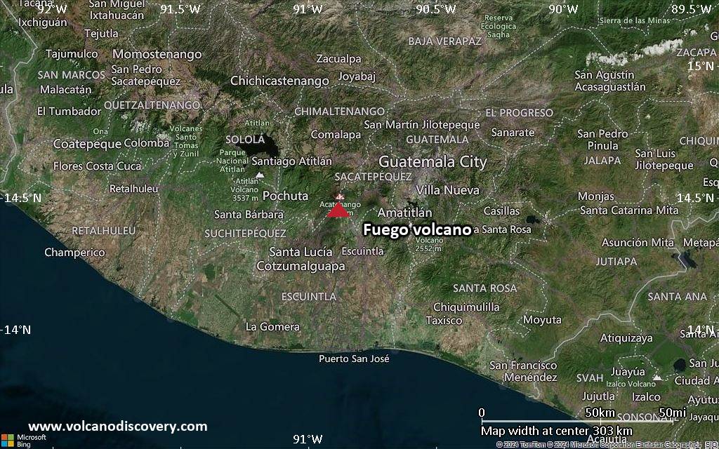
<!–div style="font-size:14px;text-align:center;border:3px solid blue;border-radius:5px;padding:3px;margin:5px;background:#eee"><a href="https://www.volcanoesandearthquakes.com/app/volcano-report.php?volcanoId=26" style="text-decoration:none" target="_blank" rel="noopener noreferrer nofollow" title="Share a volcano (activity) report, submit a photo or other interesting news!” onclick=”window.open(this.href,’Volcano Report’,’status=0,toolbar=0,location=0,directories=0,menubar=0,resizable=1,scrollbars=1,height=500,width=450′);return false”>Send Volcano Report</div–> Stratovolcano 3,763 m / 12,346 ft
Guatemala, 14.47°N / -90.88°W
Current status: erupting (4 out of 5) Fuego volcano eruptions:
1581, 1585, 1586, 1587, 1614, 1617, 1620, 1623, 1629, 1679(?), 1685, 1686, 1689(?), 1699, 1702, 1705, 1706, 1709(?), 1710,1717,1730, 1732, 1737, 1751(?), 1765(?), 1773(?), 1799, 1826, 1829, 1850(?), 1852(?), 1855, 1856, 1857, 1860, 1861(?), 1867(?), 1880, 1896, 1932, 1944, 1949, 1953, 1955, 1957, 1962, 1963, 1966, 1967, 1971, 1973, 1974, 1975, 1977, 1987, 1999, 2002 – ongoing
Typical eruption style
Dominantly explosive, construction of lava domes and extrusion of viscous lava flows. In near constant activity, at least during the past centuries.

Click this link to continue reading the article on the source website.

RSS feed source: US National Weather Service

At 915 PM CDT, Doppler radar was tracking a strong thunderstorm near Eddyville, or 21 miles south of Broken Bow, moving south at 40 mph. HAZARD…Wind gusts of 50 to 55 mph and pea size hail. SOURCE…Radar indicated. IMPACT…Gusty winds could knock down tree limbs and blow around unsecured objects. Minor hail damage to vegetation is possible. This strong thunderstorm will be near… Eddyville around 920 PM CDT. Sumner around 925 PM CDT. Other locations in the path of this storm include Elm Creek. This includes Interstate 80 between mile markers 245 and 261.

Click this link to continue reading the article on the source website.