RSS feed source: USGS Earthquake Hazards Program
Time2025-08-14 07:19:36 UTC2025-08-14 07:19:36 UTC at epicenterLocation51.288°N 157.603°EDepth69.44 km (43.15 mi)
Click this link to continue reading the article on the source website.
RSS feed source: USGS Earthquake Hazards Program
Time2025-08-14 07:19:36 UTC2025-08-14 07:19:36 UTC at epicenterLocation51.288°N 157.603°EDepth69.44 km (43.15 mi)
Click this link to continue reading the article on the source website.
RSS feed source: USGS Earthquake Hazards Program
Time2025-08-14 06:48:13 UTC2025-08-14 06:48:13 UTC at epicenterLocation1.995°S 139.020°EDepth25.96 km (16.13 mi)
Click this link to continue reading the article on the source website.
RSS feed source: USGS Earthquake Hazards Program
PAGER – GREEN ShakeMap – III DYFI? – II
Time2025-08-14 04:38:14 UTC2025-08-14 04:38:14 UTC at epicenterLocation18.372°S 172.528°WDepth10.00 km (6.21 mi)
Click this link to continue reading the article on the source website.
RSS feed source: USGS Earthquake Hazards Program
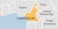
On 08/08/2025, a flood started in Cameroon, lasting until 12/08/2025 (last update). The flood caused 0 deaths and 1320 displaced .
Click this link to continue reading the article on the source website.