RSS feed source: Volcano Discovery.com--Global earthquake monitor

Mon, 28 Apr 2025, 01:50 | BY: EARTHQUAKEMONITOR

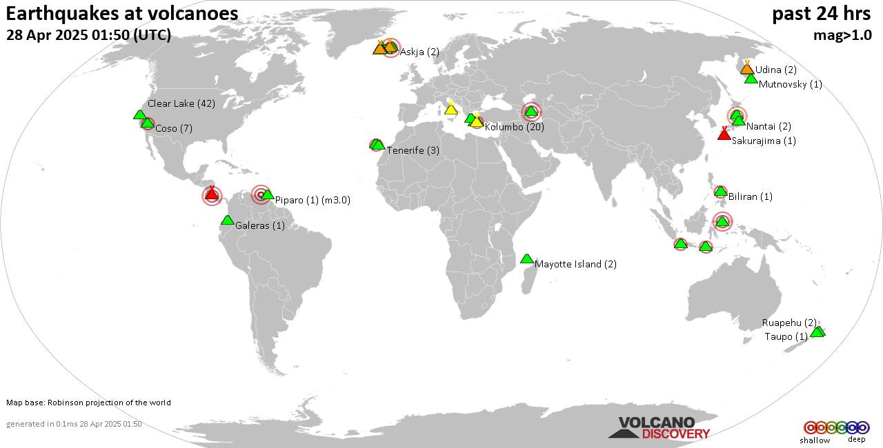
World map showing volcanoes with shallow (less than 50 km) earthquakes within 20 km radius during the past 24 hours on 28 Apr 2025 Number in brackets indicate nr of quakes.

Quakes detected near: Ambang (1 quake mag 3.0), Askja (2 quakes between mag 0.5-1.3), Bardarbunga (8 quakes between mag 0.1-3.0), Biliran (1 quake mag 2.1), Brennisteinsfjöll (3 quakes between mag 0.3-1.7), Campi Flegrei (Phlegrean Fields) (21 quakes between mag 0.1-1.6)
Chokai (2 quakes between mag 3.0-3.1), Clear Lake (42 quakes between mag 0.2-1.5), Coso (7 quakes between mag 0.9-2.1), Eldey (1 quake mag 1.4), Fagradalsfjall (26 quakes between mag 0.0-1.1), Galeras (1 quake mag 1.1), Klyuchevskoy (10 quakes between mag 0.4-1.8), Kolumbo (20 quakes between mag 0.8-2.3), Krísuvík (5 quakes between mag 0.4-1.3), La Palma (2 quakes between mag 2.1-2.1), Ljósufjöll (5 quakes between mag 0.8-1.6), Lokbatan (1 quake mag 3.0), Loki-Fögrufjöll volcano (4 quakes between mag 0.7-1.6), Mayotte Island (2 quakes between mag 1.0-1.5), Milos (2 quakes between mag 1.9-2.3), Mutnovsky (1 quake mag 1.1), Nantai (2 quakes between mag 0.1-1.2), Papandayan (1 quake mag 2.3), Piparo (1 quake mag 3.0), Poas (1 quake mag 3.0), Ruapehu (2 quakes between mag 0.8-1.0), Sakurajima (1 quake mag 1.1), Santorini (1 quake mag 1.9), Sousaki (2 quakes between mag 1.9-2.2), Svartsengi (15 quakes between mag 0.1-1.9),

Click this link to continue reading the article on the source website.
RSS feed source: Volcano Discovery.com--Global earthquake monitor

Date and TimeMag
DepthDistanceLocationDetailsMap Apr 21, 03:47 am (Yangon)

4.3

10 km61 km (38 mi) to the SE 13 km north of Taungoo, Bago Region, Myanmar 2 reportsInfoApr 19, 06:20 pm (Yangon)

4.1

10 km112 km (69 mi) to the SE 18 km northeast of Pyu, Bago Region, Myanmar InfoApr 19, 12:04 am (Yangon)

4.4

10 km49 km (30 mi) to the E Kayin, 55 km southeast of Nay Pyi Taw, Nay Pyi Taw, Myanmar 3 reportsInfoApr 15, 11:54 pm (Yangon)

4.1

15 km98 km (61 mi) to the SE 14 km north of Pyu, Bago Region, Myanmar 4 reportsInfoApr 11, 08:47 pm (Yangon)

4.1

10 km81 km (51 mi) to the N 36 km north of Nay Pyi Taw, Nay Pyi Taw, Myanmar 7 reportsInfoApr 5, 08:24 pm (Yangon)

4.3

10 km43 km (27 mi) to the NE 24 km southeast of Nay Pyi Taw, Nay Pyi Taw, Myanmar 4 reportsInfoMar 30, 06:38 am (Yangon)

4.3

10 km34 km (21 mi) to the NE 30 km southeast of Nay Pyi Taw, Nay Pyi Taw, Myanmar 2 reportsInfoMar 30, 12:58 am (Yangon)

4.4

13 km87 km (54 mi) to the SE 19 km southeast of Taungoo, Bago Region, Myanmar 4 reportsInfoMar 29, 03:50 pm (Yangon)

5.1

10 km30 km (19 mi) to the N 19 km southwest of Nay Pyi Taw, Nay Pyi Taw, Myanmar 14 reportsInfoMar 29, 05:51 am (Yangon)

5.0

10 km73 km (45 mi) to the N 25 km north of Nay Pyi Taw, Nay Pyi Taw, Myanmar 3 reportsInfoOct 27, 2018 03:46 pm (Yangon)

4.9

10 km63 km (39 mi) to the SW Myanmar 1 reportInfoOct 10, 2018 04:58 pm (Yangon)

5.2

11 km54 km (34 mi) to the

Click this link to continue reading the article on the source website.

RSS feed source: Volcano Discovery.com--Global earthquake monitor

Sun, 27 Apr 2025, 23:50 | BY: EARTHQUAKEMONITOR

World map showing volcanoes with shallow (less than 50 km) earthquakes within 20 km radius during the past 24 hours on 27 Apr 2025 Number in brackets indicate nr of quakes.

Quakes detected near: Ambang (1 quake mag 3.0), Askja (2 quakes between mag 0.5-1.3), Bardarbunga (8 quakes between mag 0.1-3.0), Biliran (1 quake mag 2.1), Brennisteinsfjöll (3 quakes between mag 0.3-1.7), Campi Flegrei (Phlegrean Fields) (20 quakes between mag 0.1-1.6)
Chokai (2 quakes between mag 3.0-3.1), Clear Lake (42 quakes between mag 0.2-1.4), Coso (6 quakes between mag 0.9-2.1), Eldey (1 quake mag 1.4), Fagradalsfjall (28 quakes between mag 0.0-1.1), Galeras (1 quake mag 1.1), Hrómundartindur (3 quakes between mag 0.6-1.7), Klyuchevskoy (4 quakes between mag 0.4-1.8), Kolumbo (26 quakes between mag 0.8-2.3), Krísuvík (3 quakes between mag 0.8-1.3), La Palma (2 quakes between mag 2.1-2.1), Ljósufjöll (6 quakes between mag 0.8-1.6), Lokbatan (1 quake mag 3.0), Loki-Fögrufjöll volcano (5 quakes between mag 0.7-1.6), Mayotte Island (2 quakes between mag 1.0-1.5), Milos (3 quakes between mag 1.9-2.3), Mutnovsky (1 quake mag 1.1), Nantai (2 quakes between mag 0.1-1.2), Papandayan (1 quake mag 2.3), Piparo (1 quake mag 3.0), Poas (1 quake mag 3.0), Ruapehu (1 quake mag 1.0), Sakurajima (1 quake mag 1.1), Santorini (1 quake mag 1.9), Sousaki (2 quakes between mag 1.9-2.2), Svartsengi

Click this link to continue reading the article on the source website.

RSS feed source: Volcano Discovery.com--Global earthquake monitor

Date and TimeMag
DepthDistanceLocationDetailsMap Apr 27, 01:41 am (Istanbul)

3.1

12 km9.7 km (6.1 mi) to the SE 15 km north of Simav, Kütahya, TurkeyI FELT IT

Info

Apr 26, 10:14 pm (Istanbul)

3.4

10.8 km8.1 km (5 mi) to the SE 18 km north of Simav, Kütahya, TurkeyI FELT IT

Info

Apr 25, 10:20 am (Istanbul)

4.6

10 km7.2 km (4.5 mi) to the E 23 km north of Simav, Kütahya, TurkeyI FELT IT23 reportsInfoApr 25, 07:29 am (Istanbul)

3.9

12 km8.1 km (5.1 mi) to the SE 17 km north of Simav, Kütahya, TurkeyI FELT IT2 reportsInfoApr 25, 07:23 am (Istanbul)

4.5

10 km6.7 km (4.2 mi) to the NE 25 km north of Simav, Kütahya, TurkeyI FELT IT6 reportsInfoApr 21, 08:24 pm (Istanbul)

4.0

7.1 km5.4 km (3.4 mi) to the SE 19 km north of Simav, Kütahya, TurkeyI FELT IT1 reportInfoApr 16, 02:19 am (Istanbul)

4.1

10 km98 km (61 mi) to the E 13 km south of Kutahya, Kütahya, Turkey InfoOct 11, 2023 12:38 pm (Istanbul)

5?

10 km50 km (31 mi) to the N 56 km south of Bursa, Bursa, Turkey (unconfirmed) 12 reportsInfoFeb 24, 2020 05:43 am (Istanbul)

4.8

10 km89 km (55 mi) to the W 12 km northeast of Akhisar, Manisa, Turkey 338 reportsInfoFeb 4, 2020 08:55 pm (Istanbul)

4.8

10 km83 km (52 mi) to the W 17 km northeast of Akhisar, Manisa, Turkey 667 reportsInfoJan 28, 2020 02:26 pm (Istanbul)

4.9

10 km91 km (56 mi) to the W 105 km northeast of İzmir, Turkey 571 reportsInfoApr 21, 2017 04:09 pm (Istanbul)

5.0

10 km62 km (38 mi) to the

Click this link to continue reading the article on the source website.