RSS feed source: Volcano Discovery.com--Global earthquake monitor

Mon, 12 May 2025, 00:20 | BY: EARTHQUAKEMONITOR

Worldwide earthquakes above magnitude 3 during the past 24 hours on 12 May 2025

Summary: 5 quakes 5.0+, 37 quakes 4.0+, 105 quakes 3.0+, 307 quakes 2.0+ (454 total)
This report is being updated every hour.
Magnitude 5+: 5 earthquakes
Magnitude 4+: 37 earthquakes
Magnitude 3+: 105 earthquakes
Magnitude 2+: 307 earthquakes
No quakes of magnitude 6 or higherTotal seismic energy estimate: 1.4 x 10¹⁴ joules (38 gigawatt hours, equivalent to 32731 tons of TNT or 2 atomic bombs!) | equivalent to ONE quake of magnitude 6.2 learn more10 largest earthquakes in the world (past 24 hours)#1: Mag 5.9 5.1 km northwest of Port Vila, Shefa Province, VanuatuSunday, May 11, 2025, at 10:22 pm (Efate time) – #2: Mag 5.9 7.8 km south of Blangpidie, IndonesiaSunday, May 11, 2025, at 03:57 pm (Jakarta time) – #3: Mag 5.6 124 km west of Xigazê, Tibet, ChinaMonday, May 12, 2025, at 05:11 am (Shanghai time) – #4: Mag 5.5 South Pacific Ocean, 126 km northeast of Nuku’alofa, Tongatapu, TongaMonday, May 12, 2025, at 11:04 am (GMT +13) – #5: Mag 5.3 54 km southwest of Beringovskiy, Chukotskiy Avtonomnyy Okrug, RussiaMonday, May 12, 2025, at 09:49 am (Anadyr time) – #6: Mag 4.9 64 km WNW of Yonakuni, JapanMonday, May 12, 2025, at 05:25 am (GMT +8) – #7: Mag 4.8 Sea of Okhotsk, Sakhalin

Click this link to continue reading the article on the source website.

RSS feed source: Volcano Discovery.com--Global earthquake monitor

Sun, 11 May 2025, 23:50 | BY: EARTHQUAKEMONITOR

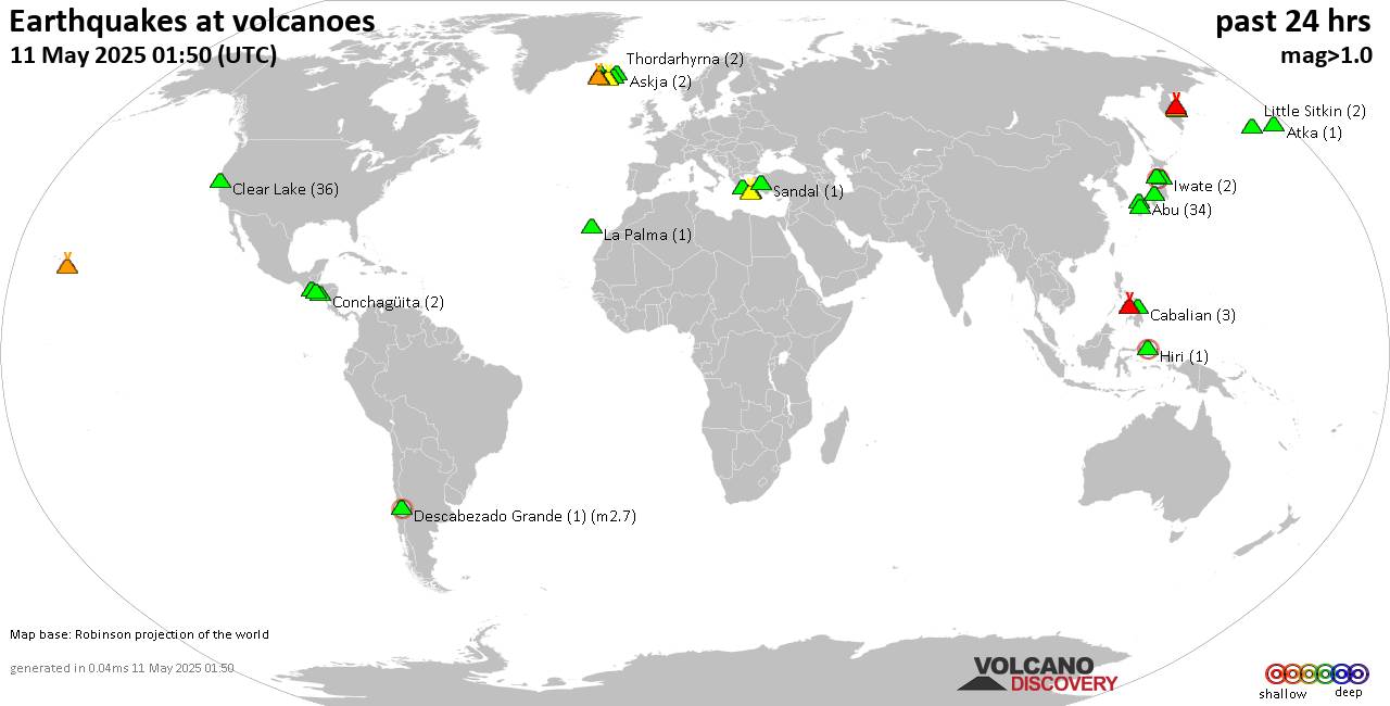
World map showing volcanoes with shallow (less than 50 km) earthquakes within 20 km radius during the past 24 hours on 11 May 2025 Number in brackets indicate nr of quakes.

Quakes detected near: Abu (65 quakes between mag 0.1-1.6), Arayat (1 quake mag 3.0), Asama (1 quake mag 3.0), Bandai (3 quakes between mag 0.4-1.0), Bishoftu Volcanic Field (1 quake mag 3.0), Canlaon (3 quakes between mag 1.5-2.3)
Clear Lake (23 quakes between mag 0.2-1.6), Conchagüita (2 quakes between mag 1.9-2.3), Coso (2 quakes between mag 0.8-1.0), Don Joao de Castro Bank (1 quake mag 2.0), Eldey (7 quakes between mag 0.5-1.5), Etna (2 quakes between mag 0.9-3.0), Gede-Pangrango (1 quake mag 1.6), Hengill (4 quakes between mag 0.1-1.0), Hiuchi (2 quakes between mag 0.4-1.1), Hrómundartindur (6 quakes between mag 0.1-2.0), Kilauea (6 quakes between mag 1.7-2.1), Kizimen (3 quakes between mag 0.5-1.1), Kolumbo (16 quakes between mag 0.9-2.3), Kozushima (1 quake mag 1.9), Kurikoma (1 quake mag 1.0), La Palma (3 quakes between mag 1.5-3.0), Ljósufjöll (4 quakes between mag 0.4-2.0), Lokbatan (1 quake mag 3.0), Mammoth Mountain (1 quake mag 1.6), Maroa (1 quake mag 1.9), Methana (2 quakes between mag 1.7-2.3), Okataina (Tarawera) (2 quakes between mag 1.2-2.7), Prestahnukur (2 quakes between mag 1.2-1.7), Salton Buttes (2 quakes between mag 1.1-1.2), Santorini

Click this link to continue reading the article on the source website.
RSS feed source: Volcano Discovery.com--Global earthquake monitor

Date and TimeMag
DepthDistanceLocationDetailsMap May 9, 03:07 pm (Yangon)

4.4

10 km94 km (59 mi) to the N 18 km east of Meiktila, Mandalay Region, MyanmarI FELT IT5 reportsInfoApr 28, 07:57 am (Yangon)

4.4

10 km83 km (52 mi) to the SW Bago Region, 47 km south of Nay Pyi Taw, Nay Pyi Taw, Myanmar 2 reportsInfoApr 19, 12:31 am (Yangon)

4.1

10 km47 km (29 mi) to the NW 1.7 km south of Yamethin, Mandalay Region, Myanmar 4 reportsInfoApr 19, 12:04 am (Yangon)

4.4

10 km78 km (48 mi) to the S 55 km southeast of Nay Pyi Taw, Nay Pyi Taw, Myanmar 3 reportsInfoApr 16, 04:57 pm (GMT +6:30)

4.1

10 km22 km (14 mi) to the NW 46 km north of Nay Pyi Taw, Nay Pyi Taw, Myanmar 1 reportInfoApr 11, 11:28 am (Yangon)

4.9

10 km102 km (63 mi) to the N Nay Pyi Taw, 16 km east of Meiktila, Mandalay Region, Myanmar 2 reportsInfoApr 1, 09:57 pm (Yangon)

4.8

3.2 km24 km (15 mi) to the W 38 km north of Nay Pyi Taw, Nay Pyi Taw, Myanmar 8 reportsInfoMar 29, 03:50 pm (Yangon)

5.1

10 km55 km (34 mi) to the SW 19 km southwest of Nay Pyi Taw, Nay Pyi Taw, Myanmar 14 reportsInfoMar 29, 05:51 am (Yangon)

5.0

10 km12 km (7.7 mi) to the SW 25 km north of Nay Pyi Taw, Nay Pyi Taw, Myanmar 3 reportsInfoMar 28, 01:15 pm (Yangon)

4.9

10 km81 km (50 mi) to the S 52 km south of Nay Pyi Taw, Nay Pyi Taw, Myanmar 35 reportsInfoMar 28, 01:09 pm (Yangon)

4.8

10 km51 km (32 mi) to the

Click this link to continue reading the article on the source website.

RSS feed source: Volcano Discovery.com--Global earthquake monitor

Date and TimeMag
DepthDistanceLocationDetailsMap May 11, 04:09 pm (Urumqi)

4.4

10 km62 km (38 mi) to the SW 142 km northwest of Tumxuk, Xinjiang, ChinaI FELT IT InfoApr 25, 01:32 am (Urumqi)

4.2

1 km53 km (33 mi) to the SE 103 km west of Aksu, Xinjiang, China 1 reportInfoApr 19, 05:37 am (Urumqi)

4.4

9 km45 km (28 mi) to the S Southern Xinjiang, China 1 reportInfoFeb 1, 02:05 am (Universal Time)

4.0

0 km43 km (27 mi) to the SW Xinjiang, China InfoJan 10, 11:48 pm (Urumqi)

4.5

10 km23 km (14 mi) to the E 94 km WNW of Aykol, China 5 reportsInfoNov 23, 2024 11:45 am (Bishkek)

4.7

2 km94 km (58 mi) to the W 154 km east of Naryn, Naryn oblast, Kyrgyzstan InfoNov 2, 2024 11:50 am (Urumqi)

4.6

10 km50 km (31 mi) to the NE 83 km northwest of Aksu, Xinjiang, China 1 reportInfoFeb 25, 2024 10:15 am (Urumqi)

5.4

10 km36 km (23 mi) to the SW 155 km west of Aksu, Xinjiang, China 153 reportsInfoJan 30, 2024 04:27 am (Urumqi)

5.7

10 km23 km (14 mi) to the SW 137 km west of Aksu, Xinjiang, China 69 reportsInfoJan 23, 2024 07:18 am (Urumqi)

5.3

3.4 km13 km (8.2 mi) to the SW 127 km west of Aksu, Xinjiang, China 6 reportsInfoJan 23, 2024 01:36 am (Urumqi)

5.5

10 km21 km (13 mi) to the SW 137 km west of Aksu, Xinjiang, China 17 reportsInfoJan 23, 2024 12:42 am (Urumqi)

5.4

10 km7.3 km (4.5 mi) to the W 129 km west of Aksu, Xinjiang, China 29 reportsInfoJan 23, 2024 12:14 am (Urumqi)

5.8

10 km19 km (12 mi) to the SW 139 km west of Aksu, Xinjiang,

Click this link to continue reading the article on the source website.