RSS feed source: Volcano Discovery.com--Global earthquake monitor

Thu, 10 Apr 2025, 23:50 | BY: EARTHQUAKEMONITOR

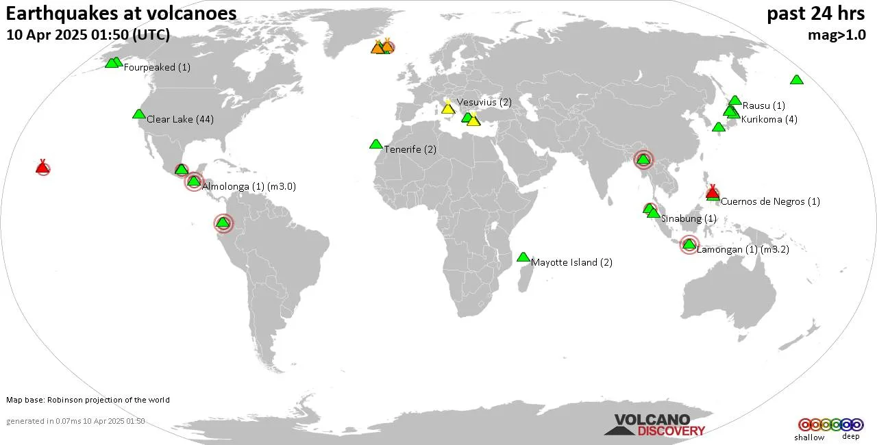
World map showing volcanoes with shallow (less than 50 km) earthquakes within 20 km radius during the past 24 hours on 10 Apr 2025 Number in brackets indicate nr of quakes.

Quakes detected near: Abu (14 quakes between mag 0.1-1.4), Askja (5 quakes between mag 0.4-1.3), Biliran (1 quake mag 2.3), Campi Flegrei (Phlegrean Fields) (30 quakes between mag 0.1-2.2), Canlaon (1 quake mag 2.5), Clear Lake (34 quakes between mag 0.0-1.8)
Concepción (1 quake mag 3.8), Coso (8 quakes between mag 0.7-3.4), El Hierro (1 quake mag 1.5), Etna (4 quakes between mag 1.0-1.3), Fagradalsfjall (22 quakes between mag 0.0-1.0), Gagak (2 quakes between mag 2.4-2.8), Haku-san (2 quakes between mag 1.0-2.2), Hiuchi (4 quakes between mag 0.1-1.0), Hrómundartindur (3 quakes between mag 0.8-2.0), Kolumbo (32 quakes between mag 0.0-3.3), Krísuvík (39 quakes between mag 0.1-1.1), Kupreanof (2 quakes between mag 1.0-1.4), La Palma (1 quake mag 1.4), Ljósufjöll (4 quakes between mag 1.2-2.0), Loki-Fögrufjöll volcano (2 quakes between mag 0.1-1.3), Maunaloa (1 quake mag 1.9), Mayotte Island (5 quakes between mag 0.8-1.7), Methana (5 quakes between mag 1.1-1.7), Nisyros (1 quake mag 2.3), Popocatépetl (1 quake mag 1.6), Prestahnukur (4 quakes between mag 1.5-1.9), Ruapehu (2 quakes between mag 0.2-1.2), Salak (3 quakes between mag 1.7-3.9), Salton Buttes (27 quakes between mag 0.9-3.1), San

Click this link to continue reading the article on the source website.
RSS feed source: Volcano Discovery.com--Global earthquake monitor

Date and TimeMag
DepthDistanceLocationDetailsMap Apr 4, 12:36 pm (GMT +8)

4.1

49 km61 km (38 mi) to the W Maluku Sea, 132 km southeast of Gorontalo, Gorontalo, IndonesiaI FELT IT InfoMar 29, 09:36 am (GMT +8)

4.6

68 km67 km (41 mi) to the W Maluku Sea, Sulawesi Utara, 126 km southeast of Gorontalo, Gorontalo, Indonesia InfoMar 22, 04:52 pm (Makassar)

4.2

187 km93 km (58 mi) to the NW Maluku Sea, Sulawesi Utara, 98 km east of Gorontalo, Gorontalo, Indonesia InfoMar 18, 12:03 am (GMT +8)

4.2

10 km77 km (48 mi) to the N Maluku Sea, 95 km south of Tondano, Indonesia 1 reportInfoMar 12, 12:40 am (GMT +8)

4.1

10 km92 km (57 mi) to the N Maluku Sea, 81 km south of Tondano, Indonesia InfoFeb 26, 06:55 am (GMT +8)

6.1

28 km66 km (41 mi) to the NE Maluku Sea, 130 km south of Manado, Kota Manado, Sulawesi Utara, Indonesia 19 reportsInfoMar 14, 2024 03:56 am (Jayapura)

6.2

10 km71 km (44 mi) to the E Maluku Sea, 193 km south of Manado, Kota Manado, Sulawesi Utara, Indonesia 4 reportsInfoAug 4, 2023 07:48 pm (Makassar)

6.0

10 km48 km (30 mi) to the E Maluku Sea, 189 km south of Manado, Kota Manado, Sulawesi Utara, Indonesia 8 reportsInfoNov 6, 2021 10:37 pm (Makassar)

6.0

44 km25 km (16 mi) to the W Maluku Sea, 165 km southeast of Gorontalo, Gorontalo, Indonesia 5 reportsInfoJun 23, 2020 03:43 pm (Makassar)

6.0

108 km97 km (60 mi) to the W Maluku Sea, 70 km southwest of Libuton Kelapa Island, Sulawesi Utara, Indonesia 13 reportsInfoJan 20, 2020 12:58 am (Makassar)

6.1

132 km78 km (49 mi)

Click this link to continue reading the article on the source website.

RSS feed source: Volcano Discovery.com--Global earthquake monitor

Date and TimeMag
DepthDistanceLocationDetailsMap Apr 9, 11:21 pm (GMT +8)

5.0

36 km99 km (61 mi) to the N Maluku Sea, 75 km southeast of Pulau Kaburuang Island, Sulawesi Utara, IndonesiaI FELT IT InfoApr 9, 03:25 pm (GMT +8)

4.9

35 km98 km (61 mi) to the N Maluku Sea, 58 km southeast of Pulau Kaburuang Island, Sulawesi Utara, IndonesiaI FELT IT InfoApr 5, 07:33 pm (GMT +8)

4.7

50 km42 km (26 mi) to the NW Maluku Sea, 114 km south of Pulau Kaburuang Island, Sulawesi Utara, IndonesiaI FELT IT InfoApr 3, 06:10 am (GMT +9)

4.9

10 km66 km (41 mi) to the SW Maluku Sea, 99 km northeast of Pulau Mayu Island, North Maluku, Indonesia InfoApr 3, 06:03 am (GMT +9)

5.9

42 km65 km (41 mi) to the SW Northern Molucca Sea 8 reportsInfoApr 9, 2024 06:48 pm (GMT +9)

6.5

10 km16 km (9.8 mi) to the N Maluku Sea, North Maluku, 122 km south of Pulau Kaburuang Island, Indonesia 11 reportsInfoNov 22, 2023 11:48 am (GMT +9)

6.0

102 km92 km (57 mi) to the S Maluku Sea, 112 km north of Ternate, Ternate, North Maluku, Indonesia 16 reportsInfoApr 21, 2023 07:21 pm (Jayapura)

6.4

10 km22 km (14 mi) to the N Indonesia: Di Laut 141 Km Tenggara Melonguane 1 reportInfoJan 18, 2023 03:06 pm (Jayapura)

7.1

64 km21 km (13 mi) to the N Maluku Sea, 116 km south of Pulau Kaburuang Island, Sulawesi Utara, Indonesia 13 reportsInfoJul 10, 2021 08:43 am (Makassar)

6.2

23 km68 km (42 mi) to the NW Indonesia: Northern Molucca Sea InfoNov 15, 2019 01:17 am (Jayapura)

7.0

27 km141 km

Click this link to continue reading the article on the source website.

RSS feed source: Volcano Discovery.com--Global earthquake monitor

Date and TimeMag
DepthDistanceLocationDetailsMap Apr 6, 07:56 pm (GMT +9)

3.5

96 km43 km (26 mi) to the NW North Pacific Ocean, 58 km east of Kushiro, Hokkaido, JapanI FELT IT

Info

Apr 5, 02:33 pm (GMT +10)

3.6

26 km97 km (60 mi) to the E North Pacific Ocean, 70 km southeast of Yuri-to Island, Yuzhno-Kurilsky, Sakhalin Oblast, RussiaI FELT IT

Info

Apr 1, 02:42 pm (GMT +9)

4.2

70 km44 km (27 mi) to the NE North Pacific Ocean, 37 km south of Nemuro, Hokkaido, Japan InfoApr 1, 03:41 pm (GMT +10)

4.1

57 km52 km (32 mi) to the ENorth Pacific Ocean, 64 km south of Yuri-to Island, Russia InfoApr 1, 03:41 pm (GMT +10)

4.2

70 km41 km (26 mi) to the NE North Pacific Ocean, 43 km south of Nemuro, Hokkaido, Japan InfoMar 25, 07:39 pm (GMT +9)

4.4

90 km60 km (37 mi) to the N 25 km west of Nemuro, Hokkaido, Japan InfoFeb 11, 11:25 am (GMT +10)

4.6

35 km6.7 km (4.2 mi) to the E North Pacific Ocean, 92 km east of Kushiro, Hokkaido, Japan InfoFeb 25, 2023 10:27 pm (GMT +9)

6.0

55 km30 km (19 mi) to the NW North Pacific Ocean, 55 km east of Kushiro, Hokkaido, Japan 43 reportsInfoJan 18, 2005 11:09 pm (GMT +9)

6.3

42 km48 km (30 mi) to the NW 40 km E of Kushiro, Japan InfoDec 6, 2004 11:15 pm (GMT +9)

6.8

35 km24 km (15 mi) to the NW North Pacific Ocean, 70 km east of Kushiro, Hokkaido, Japan InfoNov 29, 2004 03:36 am (GMT +9)

5.9

40 km38 km (24 mi) to the NW North Pacific Ocean,

Click this link to continue reading the article on the source website.