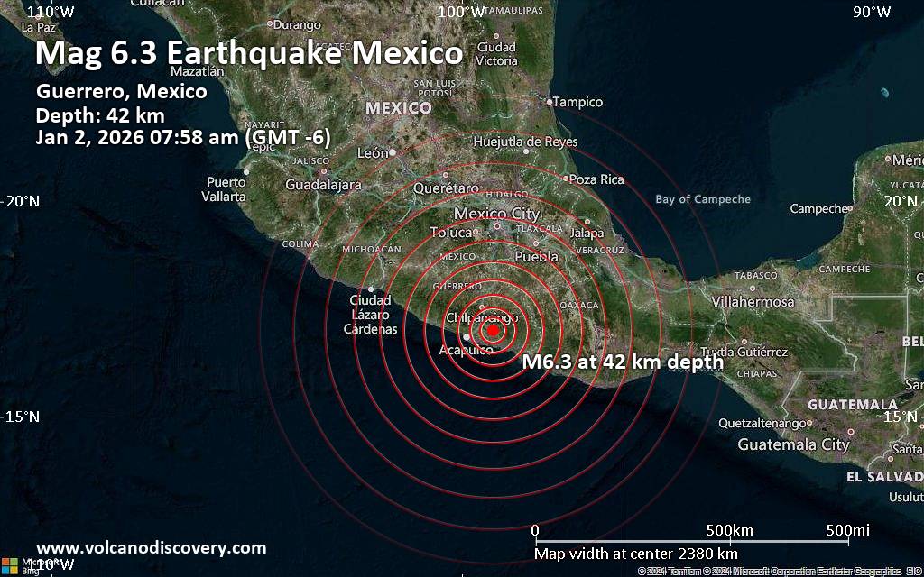
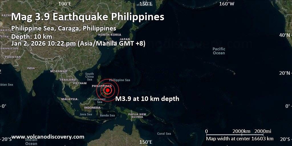
RSS feed source: Volcano Discovery.com--Global earthquake monitor

Date and TimeMag
DepthDistanceLocationDetailsMap May 27, 04:25 am (Mexico City)

4.2

147 km41 km (25 mi) to the NW 50 km west of Cintalapa de Figueroa, Estado de Chiapas, MexicoI FELT IT InfoMay 18, 07:32 pm (Mexico City)

4.0

108 km72 km (45 mi) to the SW 69 km east of Juchitan de Zaragoza, Estado de Oaxaca, Mexico InfoMay 15, 03:14 am (Mexico City)

4.3

167 km94 km (58 mi) to the NW 76 km south of Minatitlán, Estado de Veracruz-Llave, Mexico InfoMay 13, 11:05 pm (Mexico City)

4.0

136 km58 km (36 mi) to the W 68 km west of Cintalapa de Figueroa, Estado de Chiapas, Mexico InfoMay 2, 06:13 am (GMT -6)

4.0

114 km53 km (33 mi) to the SW 49 km northwest of Arriaga, Estado de Chiapas, Mexico InfoApr 23, 03:34 pm (Mexico City)

4.2

109 km72 km (45 mi) to the W 72 km northeast of Juchitan de Zaragoza, Estado de Oaxaca, Mexico InfoApr 18, 08:15 pm (Mexico City)

4.1

184 km72 km (44 mi) to the NW 77 km south of Las Choapas, Estado de Veracruz-Llave, Mexico InfoApr 18, 01:40 am (Mexico City)

4.6

142 km98 km (61 mi) to the NW 82 km south of Minatitlán, Estado de Veracruz-Llave, Mexico InfoAug 5, 2024 01:03 pm (Mexico City)

5.5

127 km27 km (17 mi) to the W Estado de Oaxaca, 37 km west of Cintalapa de Figueroa, Estado de Chiapas, Mexico 30 reportsInfoAug 9, 2023 03:33 am (Mexico City)

5.8

104 km68 km (42 mi) to the S 2.9 km southwest of Tonala, Estado de Chiapas, Mexico 140 reportsInfoMar 1, 2023 10:40 pm (Mexico City)

5.8

98 km96 km (60 mi)

Click this link to continue reading the article on the source website.

RSS feed source: Volcano Discovery.com--Global earthquake monitor

Date and TimeMag
DepthDistanceLocationDetailsMap May 25, 04:43 am (GMT +9)

4.4

197 km79 km (49 mi) to the SW Banda Sea, 134 km north of Metang Island, Maluku, IndonesiaI FELT IT InfoMay 21, 11:49 pm (GMT +9)

3.8

223 km79 km (49 mi) to the SW Banda Sea, 132 km northeast of Metang Island, Maluku, IndonesiaI FELT IT

Info

May 18, 08:33 am (GMT +9)

3.8

150 km27 km (17 mi) to the SE Banda Sea

Info

May 17, 12:57 am (GMT +9)

3.8

34 km69 km (43 mi) to the E Banda Sea, 205 km west of Tual, Kota Tual, Maluku, Indonesia

Info

May 15, 06:01 am (GMT +9)

3.9

126 km39 km (24 mi) to the E Banda Sea, 233 km west of Tual, Kota Tual, Maluku, Indonesia

Info

May 13, 01:24 am (GMT +9)

4.1

10 km95 km (59 mi) to the N Banda Sea, 245 km west of Tual, Kota Tual, Maluku, Indonesia InfoMay 12, 02:48 pm (Jayapura)

4.5

178 km44 km (28 mi) to the W Banda Sea InfoMay 4, 06:13 am (GMT +9)

4.7

142 km89 km (55 mi) to the SW Banda Sea, 122 km northeast of Metang Island, Maluku, Indonesia InfoNov 11, 2023 05:45 am (GMT +9)

6.1

10 km37 km (23 mi) to the W Banda Sea, 209 km north of Metang Island, Maluku, Indonesia InfoNov 8, 2023 10:02 pm (Jayapura)

6.7

10 km57 km (35 mi) to the W Banda Sea, 201 km north of Metang Island, Maluku, Indonesia 1 reportInfoNov 8, 2023 01:53 pm (GMT +9)

7.1

6 km95 km (59 mi) to the W Banda Sea, 166 km north of Metang Island, Maluku, Indonesia InfoNov 8, 2023 01:52

Click this link to continue reading the article on the source website.

RSS feed source: Volcano Discovery.com--Global earthquake monitor

Tue, 27 May 2025, 11:34 | BY: EARTHQUAKEMONITOR

A magnitude 4.6 earthquake near Raha, Muna Regency, Southeast Sulawesi, Indonesia, was reported only 6 minutes ago by Indonesia’s Meteorology, Climatology, and Geophysical Agency, considered the main national agency that monitors seismic activity in Indonesia. The earthquake occurred at a shallow depth of 10. km beneath the epicenter early evening on Tuesday, May 27th, 2025, at 7:27 pm local time. The exact magnitude, epicenter, and depth of the quake might be revised within the next few hours or minutes as seismologists review data and refine their calculations, or as other agencies issue their report.
Based on the preliminary seismic data, the quake should not have caused any significant damage, but was probably felt by many people as light vibration in the area of the epicenter.
Weak shaking might have been felt in Raha (pop. 70,000) located 36 km from the epicenter, Katobu (pop. 31,900) 36 km away, and Baubau (pop. 161,300) 64 km away.
VolcanoDiscovery will automatically update magnitude and depth if these change and follow up if other significant news about the quake become available. If you’re in the area, please send us your experience through our reporting mechanism, either online or via our mobile app. This will help us provide more first-hand updates to anyone around the globe who wants to know more about

Click this link to continue reading the article on the source website.

RSS feed source: Volcano Discovery.com--Global earthquake monitor

Date and TimeMag
DepthDistanceLocationDetailsMap May 27, 07:02 pm (Manila)

4.9

11 km47 km (29 mi) to the S 72 km N of Basco, Philippines  I FELT IT InfoMay 1, 10:51 pm (GMT +8)

4.9

10 km85 km (53 mi) to the E Philippine Sea, 136 km northeast of Itbayat Island, Philippines InfoApr 16, 07:13 pm (GMT +8)

4.1

10 km99 km (62 mi) to the NW 73 km ENE of Hengchun, Taiwan InfoMar 23, 06:15 am (GMT +8)

5.0

10 km52 km (32 mi) to the SE Philippine Sea, 68 km northeast of Itbayat Island, Philippines 1 reportInfoMar 4, 02:06 am (GMT +8)

4.2

10 km90 km (56 mi) to the SW Taiwan Region InfoApr 3, 2024 07:58 am (Taipei)

7.4

40 km260 km (162 mi) to the N Philippine Sea, 16 km south of Hualien City, Taiwan 232 reportsInfoJul 9, 2023 03:47 am (Taipei)

5.6

4 km56 km (35 mi) to the NW 85 km E of Hengchun, Taiwan InfoApr 8, 2022 07:36 am (GMT +8)

5.7

10 km89 km (55 mi) to the W 45 km SE of Hengchun, Taiwan InfoJul 27, 2019 09:24 am (Manila)

5.7

10 km74 km (46 mi) to the S South China Sea, 8.6 km southeast of Siayan Island, Philippines 2 reportsInfoJul 27, 2019 07:37 am (Manila)

5.9

10 km80 km (50 mi) to the S South China Sea, 12 km south of Siayan Island, Philippines 1 reportInfoApr 11, 2013 04:20 am (Manila)

5.8

12 km90 km (56 mi) to the S Philippine Sea, 26 km southeast of Siayan Island, Philippines InfoJul 13, 2008 10:58 pm (GMT +8)

6.2

14 km94 km (58 mi) to the SW South China Sea, 77 km west of Itbayat Island,

Click this link to continue reading the article on the source website.