RSS feed source: Volcano Discovery.com

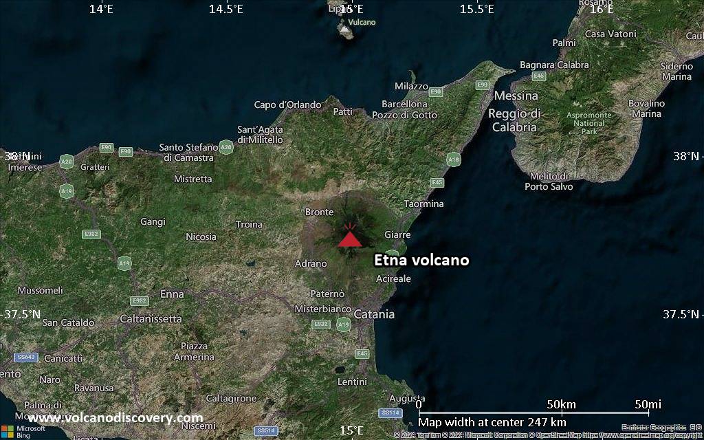
<!–div style="font-size:14px;text-align:center;border:3px solid blue;border-radius:5px;padding:3px;margin:5px;background:#eee"><a href="https://www.volcanoesandearthquakes.com/app/volcano-report.php?volcanoId=16" style="text-decoration:none" target="_blank" rel="noopener noreferrer nofollow" title="Share a volcano (activity) report, submit a photo or other interesting news!” onclick=”window.open(this.href,’Volcano Report’,’status=0,toolbar=0,location=0,directories=0,menubar=0,resizable=1,scrollbars=1,height=500,width=450′);return false”>Send Volcano Report</div–> Complex stratovolcano Currently 3,369 m / 11,053 ft (changing due to eruptive activity and collapse of its crater rims)
Sicily, Italy, 37.75°N / 14.99°E
Current status: erupting (4 out of 5) Etna volcano eruptions:
Near continuously active; some major historic eruptions include 122 BC (large Plinian outbursts that created the small caldera of the “Cratere del Piano”), 1669 AD (devastating flank eruption that destroyed 15 villages and part of Catania), 1787 (Subplinian eruption and one of the most spectacular summit eruptions on record – lava fountains reportedly up to 3000 m high).
Eruptions since 1950 (f: flank / s: summit activity): 1950 (s), 1950-51(f), 1955 (s), 1956 (s), 1956 (f), 1957 (s),1960 (s), 1961 (s), 1964 (f), 1964 (s), 1966

Click this link to continue reading the article on the source website.
RSS feed source: Volcano Discovery.com

Date and TimeMag
DepthDistanceLocationDetailsMap Apr 5, 12:09 am (GMT -6)

4.4

5.8 km55 km (34 mi) to the E North Pacific Ocean, 69 km southwest of Champerico, Retalhuleu, GuatemalaI FELT IT InfoApr 3, 05:33 pm (GMT -6)

4.0

8 km53 km (33 mi) to the NW North Pacific Ocean, 139 km southwest of Tapachula, Chiapas, MexicoI FELT IT InfoMar 26, 02:55 am (GMT -6)

4.1

17 km71 km (44 mi) to the E North Pacific Ocean, 65 km southwest of Champerico, Retalhuleu, Guatemala 1 reportInfoMar 21, 08:45 pm (GMT -6)

4.0

26 km80 km (50 mi) to the E North Pacific Ocean, 83 km southwest of Retalhuleu, Retalhuleu, Guatemala InfoMar 21, 05:16 am (GMT -6)

4.2

15 km66 km (41 mi) to the W North Pacific Ocean, 178 km southwest of Tapachula, Chiapas, Mexico InfoOct 25, 2024 08:46 am (GMT -6)

5.8

17 km35 km (22 mi) to the NE 69 km SW of Brisas Barra De Suchiate, Mexico 14 reportsInfoMay 12, 2024 05:39 am (GMT -6)

6.2

10 km49 km (31 mi) to the NE North Pacific Ocean, 87 km southwest of Tapachula, Chiapas, Mexico 312 reportsInfoDec 23, 2019 09:47 am (GMT -6)

5.7

10 km12 km (7.6 mi) to the NE Off Coast of Chiapas, Mexico 2 reportsInfoNov 19, 2019 10:27 pm (GMT -6)

6.2

10 km37 km (23 mi) to the NW Off Coast of Chiapas, Mexico 44 reportsInfoSep 7, 2017 10:49 pm (GMT -6)

8.0

60 km164 km (102 mi) to the NW North Pacific Ocean, 87 km southwest of Topon, Chiapas, Mexico 317 reportsInfoApr 25, 2016 01:07 am (GMT -6)

5.9

33 km76 km (47 mi) to the N North Pacific

Click this link to continue reading the article on the source website.

RSS feed source: Volcano Discovery.com

Tue, 8 Apr 2025, 00:24 | BY: EARTHQUAKEMONITOR

Worldwide earthquakes above magnitude 3 during the past 24 hours on 8 Apr 2025

Summary: 6 quakes 5.0+, 33 quakes 4.0+, 139 quakes 3.0+, 357 quakes 2.0+ (535 total)
Magnitude 5+: 6 earthquakes
Magnitude 4+: 33 earthquakes
Magnitude 3+: 139 earthquakes
Magnitude 2+: 357 earthquakes
No quakes of magnitude 6 or higherTotal seismic energy estimate: 6.4 x 10¹³ joules (17.8 gigawatt hours, equivalent to 15300 tons of TNT or 1 atomic bombs!) | equivalent to ONE quake of magnitude 6.0 learn more10 largest earthquakes in the world (7 Apr 2025)#1: Mag 5.8 Indian Ocean, 13 km southeast of Pulau Babi Island, IndonesiaTuesday, Apr 8, 2025, at 02:49 am (Pontianak time) – #2: Mag 5.4 North Pacific Ocean, 74 km northeast of Kharimkotan Island, Sakhalin Oblast, RussiaMonday, Apr 7, 2025, at 01:59 pm (GMT +11) – #3: Mag 5.3 Philippine Sea, 50 km south of Tinian Island, Northern Mariana IslandsMonday, Apr 7, 2025, at 05:24 pm (GMT +10) – #4: Mag 5.1 Coral Sea, 149 km southwest of New Jersey Island, Solomon IslandsTuesday, Apr 8, 2025, at 12:29 am (GMT +11) – #5: Mag 5.1 Solomon Sea, 154 km south of Lolobau Island, Papua New GuineaMonday, Apr 7, 2025, at 11:08 pm (GMT +10) – #6: Mag 5.0 Solomon Sea, 165 km south of Lolobau Island, Papua New GuineaTuesday, Apr 8, 2025,

Click this link to continue reading the article on the source website.

RSS feed source: Volcano Discovery.com

<!–div style="font-size:14px;text-align:center;border:3px solid blue;border-radius:5px;padding:3px;margin:5px;background:#eee"><a href="https://www.volcanoesandearthquakes.com/app/volcano-report.php?volcanoId=62" style="text-decoration:none" target="_blank" rel="noopener noreferrer nofollow" title="Share a volcano (activity) report, submit a photo or other interesting news!” onclick=”window.open(this.href,’Volcano Report’,’status=0,toolbar=0,location=0,directories=0,menubar=0,resizable=1,scrollbars=1,height=500,width=450′);return false”>Send Volcano Report</div–> Stratovolcano 2891 m (9,485 ft)
Western Sumatra, Indonesia, -0.39°S / 100.46°E
Current status: erupting (4 out of 5) Marapi volcano eruptions:
2011-ongoing, 2004 (Aug), 2001, 2000, 1999, 1987-94, 1984, 1984, 1983, 1982, 1980, 1975-79, 1973, 1970-71, 1968(?), 1967, 1966, 1958, 1958, 1954-57, 1950-52, 1949, 1949, 1943, 1932, 1930, 1929, 1927, 1925, 1919, 1918, 1918, 1917, 1916, 1915, 1913, 1911, 1910, 1907-08, 1905, 1904, 1889, 1888, 1886, 1885, 1883, 1878(?), 1883, 1876-77, 1876, 1871, 1871, 1863, 1861, 1855-56, 1854, 1845, 1833-34, 1822, 1807, 1770
Typical eruption style
Small to moderate sized explosions

Click this link to continue reading the article on the source website.