RSS feed source: USGS Earthquake Hazards Program
Time2025-08-13 11:00:18 UTC2025-08-13 11:00:18 UTC at epicenterLocation50.126°N 159.525°EDepth10.00 km (6.21 mi)
Click this link to continue reading the article on the source website.
RSS feed source: USGS Earthquake Hazards Program
Time2025-08-13 11:00:18 UTC2025-08-13 11:00:18 UTC at epicenterLocation50.126°N 159.525°EDepth10.00 km (6.21 mi)
Click this link to continue reading the article on the source website.
RSS feed source: USGS Earthquake Hazards Program
Time2025-08-13 11:40:34 UTC2025-08-13 11:40:34 UTC at epicenterLocation51.508°N 160.034°EDepth35.00 km (21.75 mi)
Click this link to continue reading the article on the source website.
RSS feed source: USGS Earthquake Hazards Program
Wed, 13 Aug 2025, 11:50 | BY: EARTHQUAKEMONITOR
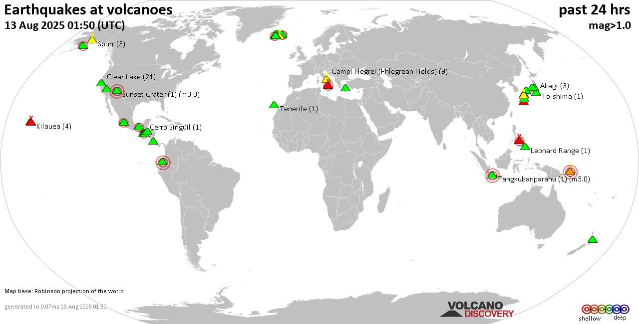
World map showing volcanoes with shallow (less than 50 km) earthquakes within 20 km radius during the past 24 hours on 13 Aug 2025 Number in brackets indicate nr of quakes.
Quakes detected near: Agua (2 quakes between mag 2.2-2.5), Akagi (2 quakes between mag 0.2-1.5), Aso (1 quake mag 1.7), Brennisteinsfjöll (3 quakes between mag 0.3-1.5), Campi Flegrei (Phlegrean Fields) (7 quakes between mag 0.1-1.1), Canlaon (3 quakes between mag 2.1-2.8)
Cerro Singüil (1 quake mag 2.4), Clear Lake (16 quakes between mag 0.5-3.0), Coso (1 quake mag 1.1), El Chichón (4 quakes between mag 2.0-3.1), Eldey (2 quakes between mag 0.9-2.0), Etna (4 quakes between mag 1.1-2.0), Fagradalsfjall (3 quakes between mag 0.2-1.2), Hiuchi (2 quakes between mag 0.4-1.1), Hualalai (1 quake mag 1.5), Katla (5 quakes between mag 0.4-2.3), Kilauea (4 quakes between mag 1.6-1.9), Kolumbo (2 quakes between mag 1.3-1.8), Krísuvík (18 quakes between mag 0.1-1.8), Kuju (4 quakes between mag 0.7-2.6), Ljósufjöll (8 quakes between mag 0.5-1.4), Mutnovsky (1 quake mag 1.9), Myoko (1 quake mag 1.7), Pelée (1 quake mag 4.7), Picos Volcanic System (1 quake mag 3.0), San Salvador (1 quake mag 3.0), Santorini (1 quake mag 1.4), Spurr (3 quakes between mag 0.2-1.5), Suwanose-jima (6 quakes between mag 1.5-2.6), Taranaki (1 quake mag 1.5), Taupo (1 quake mag
Click this link to continue reading the article on the source website.
RSS feed source: USGS Earthquake Hazards Program
Date and TimeMag
DepthDistanceLocationDetailsMap Aug 13, 04:31 pm (GMT +11)
4.9
10 km67 km (41 mi) to the N North Pacific Ocean, 155 km southeast of Petropavlovsk-Kamchatskiy, Kamchatka, Russia I FELT IT InfoAug 13, 08:41 am (Kamchatka)
4.2
58 km111 km (69 mi) to the W North Pacific Ocean, 164 km south of Petropavlovsk-Kamchatskiy, Kamchatka, Russia I FELT IT InfoAug 13, 05:07 am (GMT +12)
4.2
40 km117 km (73 mi) to the NW North Pacific Ocean, 81 km southeast of Petropavlovsk-Kamchatskiy, Kamchatka, Russia I FELT IT InfoAug 13, 03:00 am (GMT +11)
4.6
30 km53 km (33 mi) to the NW North Pacific Ocean, 158 km south of Petropavlovsk-Kamchatskiy, Kamchatka, Russia I FELT IT InfoAug 13, 02:06 am (GMT +12)
4.5
15 km99 km (61 mi) to the NW North Pacific Ocean, 118 km south of Petropavlovsk-Kamchatskiy, Kamchatka, Russia I FELT IT InfoAug 6, 09:43 pm (GMT +11)
5.5
10 km19 km (12 mi) to the W North Pacific Ocean, 186 km southeast of Petropavlovsk-Kamchatskiy, Kamchatka, Russia I FELT IT – 4 reportsInfoAug 6, 09:35 pm (GMT +11)
5.8
19 km38 km (24 mi) to the W North Pacific Ocean, 174 km south of Petropavlovsk-Kamchatskiy, Kamchatka, Russia I FELT IT – 23 reportsInfoAug 3, 02:14 am (GMT +12)
6.0
20 km36 km (22 mi) to the W North Pacific Ocean, 174 km south of Petropavlovsk-Kamchatskiy, Kamchatka, Russia I FELT IT – 10 reportsInfoAug 2, 01:44 am (Kamchatka)
5.6
73 km129 km (80 mi) to the NW 100 km S of Vilyuchinsk, Russia 5 reportsInfoAug 1, 10:57 pm (GMT +11)
5.9
19 km37 km (23 mi) to the N North Pacific Ocean, 166
Click this link to continue reading the article on the source website.