RSS feed source: Volcano Discovery.com--Global earthquake monitor

Mon, 21 Apr 2025, 12:01 | BY: EARTHQUAKEMONITOR

A very shallow magnitude 2.9 earthquake was reported in the evening near Arkaroola Village, South Australia, Australia.
According to Geoscience Australia (GeoAu), the quake hit on Monday, April 21st, 2025, at 8:40 pm local time at a very shallow depth of 3.1 miles. Shallow earthquakes are felt more strongly than deeper ones as they are closer to the surface. The exact magnitude, epicenter, and depth of the quake might be revised within the next few hours or minutes as seismologists review data and refine their calculations, or as other agencies issue their report.
A second report was later issued by the European-Mediterranean Seismological Centre (EMSC), which listed it as a magnitude 3.0 earthquake.
According to preliminary calculations, we do not expect that the quake was felt by many people and did not cause any damage. In Arkaroola Village (pop. 170, 15 miles away), Warraweena (pop. 20, 39 miles away), Copley (pop. 81, 42 miles away), Leigh Creek (pop. 270, 44 miles away), and Lyndhurst (pop. 35, 44 miles away), the quake was probably not felt.

If you felt it, report it through our site or app right now!

Download and Upgrade the Volcanoes & Earthquakes app to get one of the fastest seismic alerts online:
Android | IOS
Earthquake data:

I felt this quake

Date & time: Apr 21, 2025 09:10 pm (GMT

Click this link to continue reading the article on the source website.

RSS feed source: Volcano Discovery.com--Global earthquake monitor

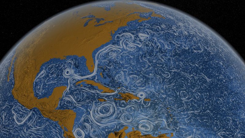
U.S. National Science Foundation-supported researchers published a new paper that explains how atmospheric wind affects eddies, an ocean weather phenomena of spinning ocean currents. “Our theory and findings provide a roadmap for incorporating interactions between winds and ocean eddies into operational and long-term forecasting,” said Hussein Aluie, a co-author on the paper and professor at the University of Rochester.

“Accurate ocean forecasts are essential for navigation and shipping, fisheries management, disaster response, coastal management and climate prediction,” Aluie said. These economic sectors rely on accurate forecasts to plan for potentially dangerous conditions.

Aluie and a team of researchers used satellite imagery and climate models to discover that not only do atmospheric winds dampen eddies, like previously thought, but they can also energize them. Prevailing winds that move longitudinally across the globe, like westerlies and trade winds, slow eddies when they move in the opposite direction but energize them if they spin the same way.

Between the eddies are ocean weather phenomenon called strain, which account for about half of the ocean’s kinetic energy. The team found that strain is also dampened or energized by wind-like eddies.

“The new energy pathways between the atmosphere and the ocean that we discovered can help design better ocean observation systems and improve climate models,” said Shikhar Rai, the study’s first author and a doctoral student at the University of Rochester,

Click this link to continue reading the article on the source website.
RSS feed source: Volcano Discovery.com--Global earthquake monitor

Date and TimeMag
DepthDistanceLocationDetailsMap Apr 13, 02:55 am (GMT +12)

4.6

302 km89 km (55 mi) to the S South Pacific Ocean, Gisborne, 226 km south of Raoul Island, New Zealand InfoApr 11, 03:11 am (GMT +12)

4.2

303 km73 km (45 mi) to the NW Gisborne, New Zealand InfoApr 2, 12:28 pm (GMT +12)

4.0

300 km56 km (35 mi) to the E New Zealand InfoMar 29, 12:34 pm (GMT +13)

4.2

500 km94 km (58 mi) to the SE New Zealand InfoMar 27, 09:41 am (GMT +12)

4.9

35 km85 km (53 mi) to the NE South Pacific Ocean, 93 km south of Raoul Island, New Zealand InfoFeb 3, 03:15 am (GMT +13)

4.6

140 km38 km (23 mi) to the S South Pacific Ocean, Manawatu-Wanganui, 181 km south of Raoul Island, New Zealand InfoFeb 3, 03:15 am (GMT +13)

4.6

140 km38 km (23 mi) to the S South Pacific Ocean, 181 km south of Raoul Island, New Zealand InfoJan 28, 10:23 pm (GMT +12)

5.2

63 km39 km (24 mi) to the E South Pacific Ocean, 127 km south of Raoul Island, New Zealand 12 reportsInfoMar 4, 2023 07:41 pm (Auckland)

6.2

214 km50 km (31 mi) to the N New Zealand 3 reportsInfoFeb 13, 2023 09:18 pm (GMT +12)

6.2

343 km95 km (59 mi) to the N New Zealand 4 reportsInfoMar 5, 2021 07:28 am (GMT +12)

8.1

29 km142 km (88 mi) to the NE South Pacific Ocean, 81 km southeast of Raoul Island, New Zealand 15 reportsInfoJun 19, 2019 07:01 pm (GMT +12)

6.4

60 km33 km (20 mi) to the E South Pacific Ocean, 135 km south of Raoul Island, New Zealand 2 reportsInfoJun

Click this link to continue reading the article on the source website.

RSS feed source: Volcano Discovery.com--Global earthquake monitor

Date and TimeMag
DepthDistanceLocationDetailsMap Mar 24, 02:15 am (Tehran)

4.0

10 km91 km (57 mi) to the N 12 km northwest of Yasuj, Kohgiluyeh and Boyer-Ahmad Province, Iran InfoMar 10, 12:16 pm (Tehran)

4.7

10 km58 km (36 mi) to the S 17 km southwest of Kazerun, Fars, Iran InfoJan 19, 11:00 am (Tehran)

4.3

10 km71 km (44 mi) to the SW 36 km north of Borazjan, Bushehr, Iran InfoJan 17, 03:40 am (Tehran)

4.2

10 km92 km (57 mi) to the W 38 km east of Bandar-e Genaveh, Bushehr, Iran InfoJan 17, 01:15 am (Tehran)

4.3

10 km89 km (55 mi) to the SW 43 km northwest of Borazjan, Bushehr, Iran InfoJan 16, 10:50 pm (Tehran)

4.7

10 km76 km (47 mi) to the SW 44 km north of Borazjan, Bushehr, Iran 1 reportInfoNov 21, 2024 08:29 am (Tehran)

5.0

10 km90 km (56 mi) to the SW 7.7 km east of Borazjan, Bushehr, Iran 1 reportInfoOct 20, 2023 02:13 am (Tehran)

4.8

10 km45 km (28 mi) to the SE 40 km E of Kāzerūn, Iran 7 reportsInfoMar 28, 2023 08:35 pm (Tehran)

4.5

10 km36 km (22 mi) to the N 31 km northeast of Nurabad, Fars, Iran InfoJul 18, 2021 06:04 pm (Tehran)

5.3

10 km80 km (50 mi) to the SW 43 km north of Borazjan, Bushehr, Iran 196 reportsInfoMay 6, 2018 11:27 pm (Tehran)

5.3

10 km87 km (54 mi) to the N 10.4 km west of Yasuj, Kohgiluyeh and Boyer-Ahmad Province, Iran 9 reportsInfoMay 2, 2018 07:38 am (Tehran)

5.3

8 km88 km (55 mi) to the N 10.2 km northwest of Yasuj, Kohgiluyeh and Boyer-Ahmad Province, Iran 10 reportsInfoNov 28, 2013 05:21 pm (Tehran)

5.8

8 km85 km

Click this link to continue reading the article on the source website.