RSS feed source: Volcano Discovery.com--Global earthquake monitor

Sun, 31 Aug 2025, 23:50 | BY: EARTHQUAKEMONITOR

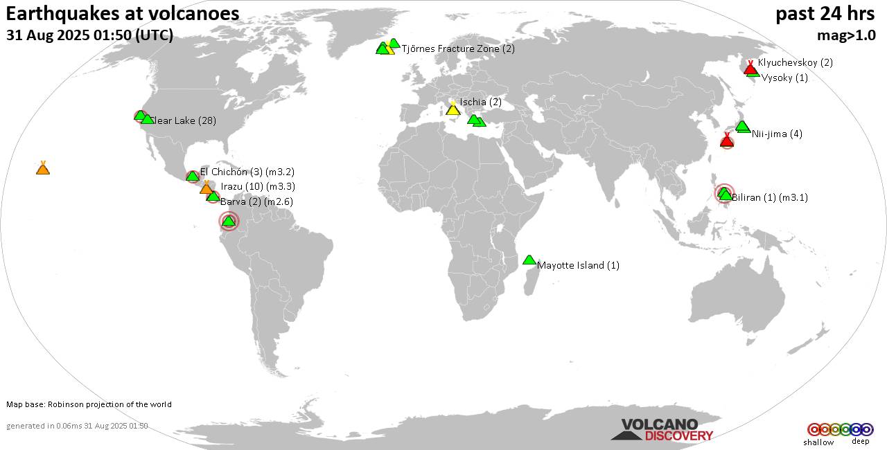
World map showing volcanoes with shallow (less than 50 km) earthquakes within 20 km radius during the past 24 hours on 31 Aug 2025 Number in brackets indicate nr of quakes.

Quakes detected near: Akuseki-jima (3 quakes between mag 2.4-2.8), Apaneca Range (1 quake mag 2.0), Askja (1 quake mag 1.5), Bardarbunga (1 quake mag 1.4), Bezymianny (2 quakes between mag 0.3-1.0), Brennisteinsfjöll (3 quakes between mag 0.6-1.2)
Campi Flegrei (Phlegrean Fields) (50 quakes between mag 0.1-3.3), Clear Lake (26 quakes between mag 0.2-2.0), Coso (5 quakes between mag 0.2-1.8), El Chichón (2 quakes between mag 2.3-2.9), Eldey (53 quakes between mag 0.2-3.3), Galeras (1 quake mag 1.1), Hofsjökull (5 quakes between mag 0.6-2.8), Hrómundartindur (2 quakes between mag 0.5-1.6), Katla (16 quakes between mag 0.4-2.1), Kilauea (1 quake mag 1.8), Klyuchevskoy (5 quakes between mag 1.2-1.7), Kolumbo (2 quakes between mag 1.7-2.0), Krafla (2 quakes between mag 0.2-1.0), Krísuvík (23 quakes between mag 0.0-1.7), Ljósufjöll (3 quakes between mag 0.8-1.5), Maunaloa (1 quake mag 2.6), Michoacán-Guanajuato (4 quakes between mag 1.7-2.5), Miyake-shima (1 quake mag 1.7), Mt Fuji (1 quake mag 1.1), Nemrut Dagi (2 quakes between mag 1.1-1.4), Nii-jima (2 quakes between mag 1.0-1.0), Pico de Orizaba (1 quake mag 2.8), San José (1 quake mag 2.5), Sangay (Philippines) (1 quake mag 1.5), Santorini

Click this link to continue reading the article on the source website.

RSS feed source: Volcano Discovery.com--Global earthquake monitor

Date and TimeMag
DepthDistanceLocationDetailsMap Sep 1, 02:03 am (GMT +4:30)

5.2

10 km13 km (8.4 mi) to the N 44 km southwest of Asadabad, Kunar, AfghanistanI FELT IT2 reportsInfoSep 1, 12:59 am (GMT +4:30)

4.5

10 km22 km (14 mi) to the NE 31 km southwest of Asadabad, Kunar, AfghanistanI FELT IT InfoSep 1, 12:08 am (GMT +4:30)

4.5

10 km33 km (20 mi) to the SE 41 km east of Jalalabad, Nangarhar, AfghanistanI FELT IT2 reportsInfoAug 31, 11:47 pm (GMT +4:30)

6.0

8 km8.6 km (5.3 mi) to the SE Nangarhar, 55 km southwest of Asadabad, Kunar, AfghanistanI FELT IT126 reportsInfoMay 9, 01:22 am (GMT +4:30)

4.3

10 km88 km (55 mi) to the NE Nuristan, 45 km north of Asadabad, Kunar, Afghanistan InfoJun 19, 2024 08:47 am (GMT +4:30)

4.8

70 km55 km (34 mi) to the NW 25 km north of Mehtar Lam, Laghman, Afghanistan 17 reportsInfoJan 19, 2023 04:00 pm (GMT +4:30)

5.1

104 km124 km (77 mi) to the NE Nuristan, 78 km north of Asadabad, Kunar, Afghanistan 36 reportsInfoSep 5, 2022 02:27 am (GMT +4:30)

5.1

10 km8.5 km (5.3 mi) to the N 35 km NE of Jal?l?b?d, Afghanistan 79 reportsInfoAug 5, 2021 06:56 am (Karachi)

4.7

10 km114 km (71 mi) to the NE 182km NW of Islamabad, Pakistan InfoOct 26, 2015 01:39 pm (GMT +4:30)

7.5

207 km211 km (131 mi) to the N 77 km southeast of Fayzabad, Badakhshan, Afghanistan InfoApr 24, 2013 09:25 am (Universal Time)

5.3

63 km44 km (28 mi) to the W Southeastern Afghanistan InfoApr 24, 2013 01:55 pm (GMT +4:30)

5.5

64 km44 km (27 mi) to the

Click this link to continue reading the article on the source website.

RSS feed source: Volcano Discovery.com--Global earthquake monitor

<!–div style="font-size:14px;text-align:center;border:3px solid blue;border-radius:5px;padding:3px;margin:5px;background:#eee"><a href="https://www.volcanoesandearthquakes.com/app/volcano-report.php?volcanoId=26" style="text-decoration:none" target="_blank" rel="noopener noreferrer nofollow" title="Share a volcano (activity) report, submit a photo or other interesting news!” onclick=”window.open(this.href,’Volcano Report’,’status=0,toolbar=0,location=0,directories=0,menubar=0,resizable=1,scrollbars=1,height=500,width=450′);return false”>Send Volcano Report</div–> Stratovolcano 3,763 m / 12,346 ft
Guatemala, 14.47°N / -90.88°W
Current status: erupting (4 out of 5) Fuego volcano eruptions:
1581, 1585, 1586, 1587, 1614, 1617, 1620, 1623, 1629, 1679(?), 1685, 1686, 1689(?), 1699, 1702, 1705, 1706, 1709(?), 1710,1717,1730, 1732, 1737, 1751(?), 1765(?), 1773(?), 1799, 1826, 1829, 1850(?), 1852(?), 1855, 1856, 1857, 1860, 1861(?), 1867(?), 1880, 1896, 1932, 1944, 1949, 1953, 1955, 1957, 1962, 1963, 1966, 1967, 1971, 1973, 1974, 1975, 1977, 1987, 1999, 2002 – ongoing
Typical eruption style
Dominantly explosive, construction of lava domes and extrusion of viscous lava flows. In near constant activity, at least during the past centuries.

Click this link to continue reading the article on the source website.