RSS feed source: Volcano Discovery.com--Global earthquake monitor

Saturday, Nov 22, 2025 12:25 | 5 mins ago | By: EarthquakeMonitor

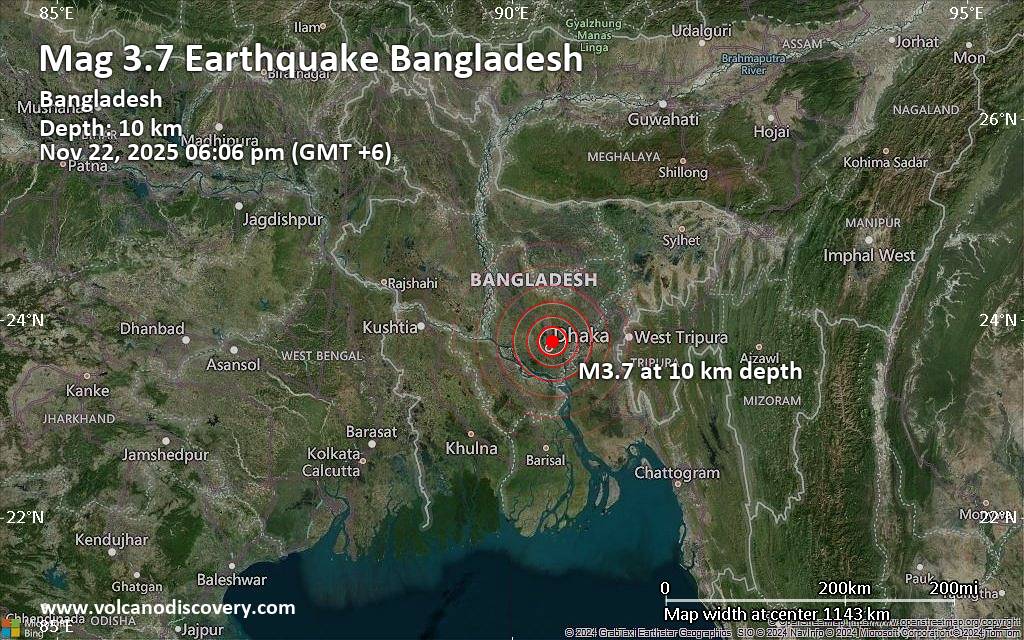
A magnitude 3.7 earthquake near Dhaka, Dhaka Division, Bangladesh, was reported only 18 minutes ago by the European-Mediterranean Seismological Centre (EMSC), considered one of the key international agencies that monitor seismic activity worldwide. The earthquake occurred at a shallow depth of 10. km beneath the epicenter early evening on Saturday, November 22nd, 2025, at 6:06 pm local time. The exact magnitude, epicenter, and depth of the quake might be revised within the next few hours or minutes as seismologists review data and refine their calculations, or as other agencies issue their report.
Our monitoring service identified a second report from the citizen-seismograph network of RaspberryShake which listed the quake at magnitude 3.7 as well.
Based on the preliminary seismic data, the quake should not have caused any significant damage, but was probably felt by many people as light vibration in the area of the epicenter.
Weak shaking might have been felt in Bhatara (pop. 324,300) located 2 km from the epicenter, Paltan (pop. 184,500) 6 km away, Kafrul (pop. 339,700) 7 km away, Matuail (pop. 34,300) 8 km away, Azimpur (pop. 96,600) 8 km away, Dhaka (pop. 10,356,500) 8 km away, Tungi (pop. 337,600) 13 km away, and Narayanganj (pop. 223,600) 20 km away.
Other towns or cities near the epicenter where

Click this link to continue reading the article on the source website.

RSS feed source: Volcano Discovery.com--Global earthquake monitor

Support Us – Help Us Enhance Our Services! We’re passionate about delivering the latest volcano and earthquake data from around the globe — just for you. However, maintaining our website and free apps requires significant time, effort, and resources.
Your support helps us expand our hardware and software capabilities and empowers our dedicated editorial team. Our mission is to provide uninterrupted, real-time updates whenever an earthquake strikes or a volcano erupts — and your donations make this possible. Every contribution, big or small, is deeply appreciated. If you find our information valuable and want to help us add new features, create compelling content, and improve our technology, please consider making a donation: Donate with PayPal: Planned Features: Improved multilingual support Tsunami alerts Faster responsiveness Thanks to your past donations, we have recently added: Design upgrades Detailed earthquake statistics Additional seismic data sources Download the Volcanoes & Earthquakes app to stay among the first to receive the fastest seismic and volcano alerts online:
Android | iOS

Thank you for being part of our mission!

Click this link to continue reading the article on the source website.

RSS feed source: Volcano Discovery.com--Global earthquake monitor

Date and TimeMag
DepthDistanceLocationDetailsMap Nov 16, 02:35 pm (Manila)

4.5

86 km66 km (41 mi) to the N Philippine Sea, 54 km south of Mati, PhilippinesI FELT IT1 reportInfoNov 7, 10:27 am (GMT +8)

4.2

135 km16 km (10.2 mi) to the NW Mindanao, Philippines InfoNov 4, 10:30 pm (Manila)

4.4

27 km85 km (53 mi) to the W Province of Sarangani, 42 km southeast of General Santos, Philippines InfoNov 1, 06:02 am (GMT +8)

4.3

10 km96 km (60 mi) to the E Philippine Sea, 130 km southeast of Mati, Philippines 1 reportInfoOct 28, 01:03 am (Makassar)

4.5

84 km74 km (46 mi) to the SE Mindanao, Philippines InfoOct 26, 10:05 pm (GMT +8)

4.7

109 km87 km (54 mi) to the E Philippine Sea, 163 km southeast of Mati, Philippines InfoOct 10, 09:43 am (Manila)

7.4

58 km162 km (100 mi) to the N 20 km E of Santiago, Philippines 451 reportsInfoJun 28, 07:07 am (GMT +8)

6.1

102 km71 km (44 mi) to the S Philippine Sea, 71 km east of Sarangani Island, Philippines 56 reportsInfoMar 8, 2024 05:11 pm (GMT +8)

6.0

115 km77 km (48 mi) to the E Mindanao, Philippines 26 reportsInfoDec 2, 2023 10:37 pm (Manila)

7.6

40 km293 km (182 mi) to the N Philippine Sea, 36 km north of Bislig, Philippines 565 reportsInfoOct 4, 2023 07:21 pm (GMT +8)

6.4

113 km69 km (43 mi) to the S Philippine Sea, 64 km east of Sarangani Island, Philippines 131 reportsInfoAug 11, 2021 05:46 pm (GMT +0)

7.0

63 km84 km (52 mi) to the NE Mindanao, Philippines 617 reportsInfoSep 6, 2020 11:23 pm (Manila)

6.3

128 km77 km (48 mi) to the NW Philippine Sea, 4 km

Click this link to continue reading the article on the source website.

RSS feed source: Volcano Discovery.com--Global earthquake monitor

<!–div style="font-size:14px;text-align:center;border:3px solid blue;border-radius:5px;padding:3px;margin:5px;background:#eee"><a href="https://www.volcanoesandearthquakes.com/app/volcano-report.php?volcanoId=44" style="text-decoration:none" target="_blank" rel="noopener noreferrer nofollow" title="Share a volcano (activity) report, submit a photo or other interesting news!” onclick=”window.open(this.href,’Volcano Report’,’status=0,toolbar=0,location=0,directories=0,menubar=0,resizable=1,scrollbars=1,height=500,width=450′);return false”>Send Volcano Report</div–> Stratovolcano 3676 m (12,060 ft)
East Java, Indonesia, -8.11°S / 112.92°E
Current status: erupting (4 out of 5) Semeru volcano eruptions:
1818, 1829, 1830, 1832, 1836, 1838, 1842, 1844, 1845, 1848, 1849(?), 1851, 1856, 1857, 1865, 1866(?), 1887, 1887, 1888, 1889-91, 1892, 1893, 1893-94, 1895, 1896, 1897, 1899, 1899, 1900, 1901, 1903, 1904, 1905, 1907, 1908, 1909-10, 1910-11, 1911, 1912, 1913, 1941-42, 1945, 1946, 1946-47, 1950-64, 1967-ongoing
Typical eruption style
Explosive. Near constant strombolian activity, occasionally stronger explosions, lava flows and pyroclastic flows.

Click this link to continue reading the article on the source website.