RSS feed source: USGS Earthquake Hazards Program
Time2025-11-20 00:15:35 UTC2025-11-20 00:15:35 UTC at epicenterLocation0.637°N 120.461°EDepth17.25 km (10.72 mi)
Click this link to continue reading the article on the source website.
RSS feed source: USGS Earthquake Hazards Program
Time2025-11-20 00:15:35 UTC2025-11-20 00:15:35 UTC at epicenterLocation0.637°N 120.461°EDepth17.25 km (10.72 mi)
Click this link to continue reading the article on the source website.
RSS feed source: USGS Earthquake Hazards Program
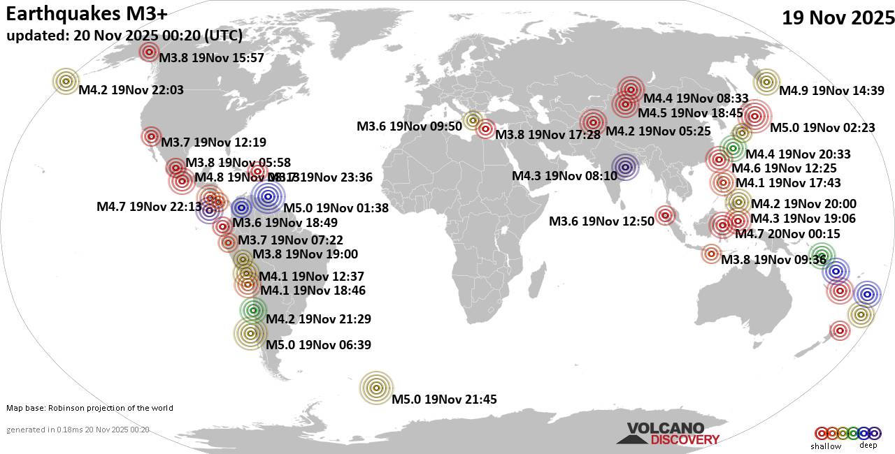
Thursday, Nov 20, 2025 00:20 | 7 mins ago | By: EarthquakeMonitor
Worldwide earthquakes above magnitude 3 during the past 24 hours on 20 Nov 2025
Summary: 4 quakes 5.0+, 42 quakes 4.0+, 173 quakes 3.0+, 365 quakes 2.0+ (584 total)
This report is being updated every hour.
Magnitude 5+: 4 earthquakes
Magnitude 4+: 42 earthquakes
Magnitude 3+: 173 earthquakes
Magnitude 2+: 365 earthquakes
No quakes of magnitude 6 or higherTotal seismic energy estimate: 2.3 x 10¹³ joules (6.51 gigawatt hours, equivalent to 5603 tons of TNT or 0.4 atomic bombs!) | equivalent to ONE quake of magnitude 5.7 learn more10 largest earthquakes in the world (past 24 hours)#1: Mag 5.0 North Pacific Ocean, 206 km east of Morioka, Iwate, JapanWednesday, Nov 19, 2025, at 12:23 pm (GMT +10) – #2: Mag 5.0 South Pacific Ocean, 132 km west of Lebu, Arauco, Region del Biobio, ChileWednesday, Nov 19, 2025, at 01:39 am (GMT -5) – #3: Mag 5.0 Caribbean Sea, 60 km northwest of Gueiria, Sucre, VenezuelaTuesday, Nov 18, 2025, at 09:38 pm (Caracas time) – #4: Mag 5.0 South Atlantic Ocean, 84 km northeast of Montagu Island, South Georgia and the South Sandwich IslandsWednesday, Nov 19, 2025, at 07:45 pm (GMT -2) – #5: Mag 4.9 North Pacific Ocean, 157 km southeast of Petropavlovsk-Kamchatskiy, Kamchatka, RussiaThursday, Nov 20, 2025, at 01:39 am (GMT +11) – #6: Mag
Click this link to continue reading the article on the source website.
RSS feed source: USGS Earthquake Hazards Program
Date and TimeMag
DepthDistanceLocationDetailsMap Sep 2, 01:01 pm (Makassar)
4.1
65 km26 km (16 mi) to the SE 168 km northeast of Palu, Kota Palu, Sulawesi Tengah, Indonesia InfoJul 27, 11:21 am (Makassar)
4.3
58 km82 km (51 mi) to the E 203 km northeast of Palu, Kota Palu, Sulawesi Tengah, Indonesia InfoApr 25, 02:09 pm (Makassar)
4.5
10 km16 km (9.9 mi) to the NE Kabupaten Parigi Moutong, 187 km northeast of Palu, Indonesia InfoMar 22, 11:46 am (Makassar)
4.1
5 km74 km (46 mi) to the NW Makassar Strait, 32 km west of Pulau Simatang Island, Sulawesi Tengah, Indonesia InfoMar 14, 07:13 pm (Makassar)
5.4
21 km73 km (45 mi) to the N Makassar Strait, 19 km northwest of Pulau Simatang Island, Indonesia InfoJan 28, 10:53 pm (Makassar)
5.8
76 km86 km (53 mi) to the E Kabupaten Parigi Moutong, 219 km northeast of Palu, Indonesia 16 reportsInfoOct 20, 2024 01:24 pm (Makassar)
4.8
88 km71 km (44 mi) to the E 187 km northeast of Palu, Kota Palu, Sulawesi Tengah, Indonesia InfoOct 20, 2024 02:07 am (Makassar)
5.5
35 km67 km (41 mi) to the W Makassar Strait, 81 km southwest of Pulau Simatang Island, Indonesia InfoSep 9, 2023 10:43 pm (Makassar)
6.3
10 km92 km (57 mi) to the SW Makassar Strait, 105 km north of Palu, Kota Palu, Sulawesi Tengah, Indonesia 5 reportsInfoMar 25, 2021 05:23 am (Makassar)
5.2
576 km77 km (48 mi) to the NE Kabupaten Toli-Toli, 248 km northeast of Palu, Indonesia InfoOct 9, 2018 05:15 am (Makassar)
5.1
10 km81 km (50 mi) to the SW Kabupaten Parigi Moutong, 100 km north of Palu, Indonesia 2 reportsInfoSep 28, 2018
Click this link to continue reading the article on the source website.
RSS feed source: USGS Earthquake Hazards Program
Time2025-11-19 22:39:15 UTC2025-11-19 22:39:15 UTC at epicenterLocation15.789°S 167.839°EDepth192.08 km (119.35 mi)
Click this link to continue reading the article on the source website.