RSS feed source: USGS Earthquake Hazards Program
Time2025-04-26 00:27:47 UTC2025-04-26 00:27:47 UTC at epicenterLocation22.222°S 170.476°EDepth10.00 km (6.21 mi)
Click this link to continue reading the article on the source website.
RSS feed source: USGS Earthquake Hazards Program
Time2025-04-26 00:27:47 UTC2025-04-26 00:27:47 UTC at epicenterLocation22.222°S 170.476°EDepth10.00 km (6.21 mi)
Click this link to continue reading the article on the source website.
RSS feed source: USGS Earthquake Hazards Program
Date and TimeMag
DepthDistanceLocationDetailsMap Apr 6, 05:29 pm (GMT +11)
4.9
112 km67 km (42 mi) to the NW South Pacific Ocean, 420 km east of Noumea, Province Sud, New Caledonia InfoFeb 20, 07:06 pm (Universal Time)
4.6
10 km54 km (34 mi) to the W South Pacific Ocean, 399 km east of Noumea, Province Sud, New Caledonia InfoFeb 16, 08:36 am (Universal Time)
5.0
10 km42 km (26 mi) to the S Southeast of the Loyalty Islands InfoFeb 4, 12:02 am (GMT +11)
5.5
10 km97 km (61 mi) to the SE South Pacific Ocean, 379 km east of Mare Island, Loyalty Islands, New Caledonia InfoJan 14, 06:00 am (GMT +11)
4.5
10 km44 km (27 mi) to the SSoutheast of the Loyalty Islands InfoApr 19, 2024 08:18 pm (GMT +11)
5.7
87 km22 km (14 mi) to the N Southeast of the Loyalty Islands 5 reportsInfoDec 7, 2023 11:56 pm (GMT +11)
7.1
48 km230 km (143 mi) to the NW Vanuatu 29 reportsInfoOct 18, 2023 12:40 am (GMT +11)
5.6
10 km11 km (7 mi) to the SW South Pacific Ocean, 292 km east of Mare Island, Loyalty Islands, New Caledonia 1 reportInfoSep 24, 2023 02:51 am (GMT +11)
5.3
10 km45 km (28 mi) to the W South Pacific Ocean, 265 km east of Mare Island, Loyalty Islands, New Caledonia 1 reportInfoJun 8, 2023 08:19 pm (GMT +11)
5.7
11 km63 km (39 mi) to the SW 263 km ESE of Tadine, New Caledonia InfoMay 20, 2023 12:50 pm (GMT +11)
7.1
27 km107 km (66 mi) to the S Southeast of the Loyalty Islands 25 reportsInfoMay 19, 2023 01:57 pm (GMT +11)
7.7
18 km122 km (76 mi)
Click this link to continue reading the article on the source website.
RSS feed source: USGS Earthquake Hazards Program
Date and TimeMag
DepthDistanceLocationDetailsMap Apr 10, 08:33 am (GMT +9)
4.5
66 km83 km (52 mi) to the N 7.4 km southwest of Kamaishi, Iwate, Japan InfoApr 9, 09:10 am (GMT +9)
4.1
50 km83 km (51 mi) to the N North Pacific Ocean, 35 km east of Kamaishi, Iwate, Japan InfoMar 30, 09:31 pm (GMT +9)
4.2
40 km17 km (10.8 mi) to the E North Pacific Ocean, 88 km east of Ishinomaki, Miyagi-ken, Japan InfoMar 30, 09:30 pm (GMT +9)
4.2
40 km17 km (10.6 mi) to the E North Pacific Ocean, 77 km southeast of Ofunato, Iwate, Japan InfoMar 25, 08:19 am (GMT +9)
4.4
64 km79 km (49 mi) to the SW 69 km E of Sōma, Japan InfoFeb 23, 04:08 am (Universal Time)
4.6
63 km63 km (39 mi) to the S North Pacific Ocean, 92 km east of Sendai, Miyagi-ken, Japan 1 reportInfoFeb 20, 08:25 am (GMT +9)
4.3
68 km49 km (30 mi) to the NE North Pacific Ocean, 66 km southeast of Kamaishi, Iwate, Japan InfoFeb 20, 08:25 am (GMT +9)
4.3
63 km40 km (25 mi) to the NE North Pacific Ocean, 61 km southeast of Kamaishi, Iwate, Japan InfoMar 16, 2022 11:36 pm (GMT +9)
7.3
41 km99 km (61 mi) to the SW 57 km ENE of Namie, Japan 101 reportsInfoMay 1, 2021 10:27 am (GMT +9)
6.7
61 km55 km (34 mi) to the SW Near East Coast of Honshu, Japan 98 reportsInfoMar 20, 2021 06:09 pm (GMT +9)
6.9
44 km60 km (37 mi) to the W 16 km northeast of Ishinomaki, Miyagi-ken, Japan 218 reportsInfoFeb 13, 2021 11:07 pm (GMT +9)
7.0
56 km96 km (60 mi) to the
Click this link to continue reading the article on the source website.
RSS feed source: USGS Earthquake Hazards Program
Fri, 25 Apr 2025, 23:50 | BY: EARTHQUAKEMONITOR
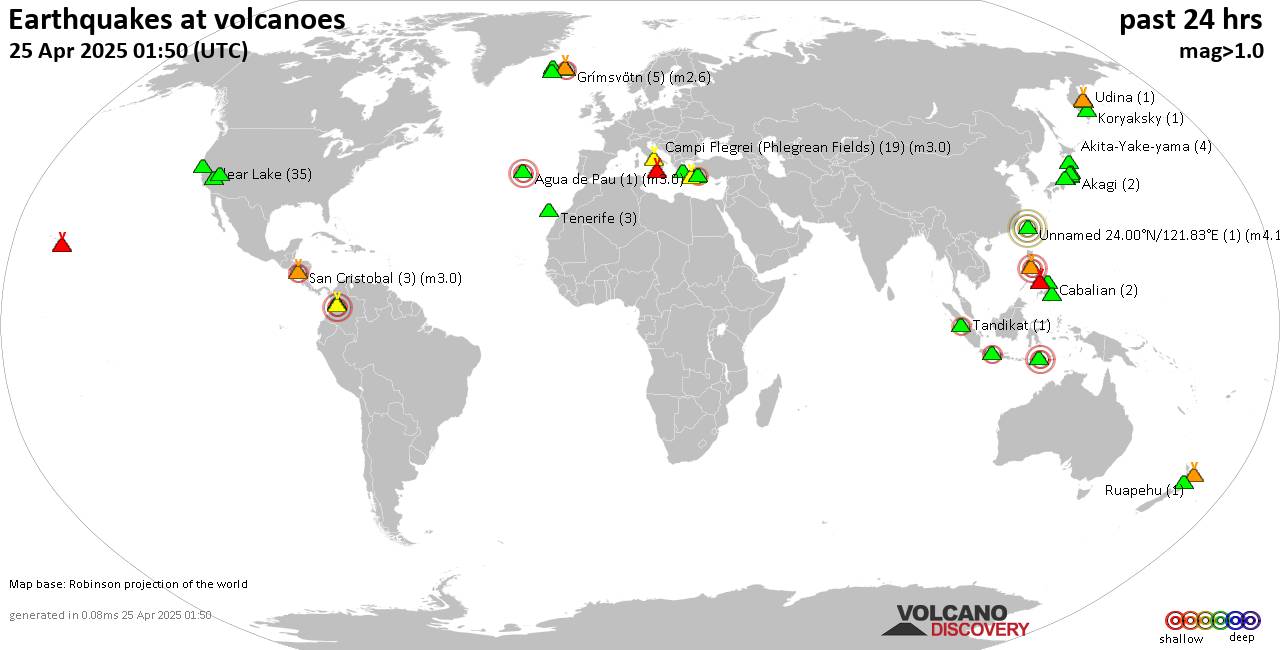
World map showing volcanoes with shallow (less than 50 km) earthquakes within 20 km radius during the past 24 hours on 25 Apr 2025 Number in brackets indicate nr of quakes.
Quakes detected near: Apaneca Range (2 quakes between mag 2.0-2.9), Bardarbunga (7 quakes between mag 0.4-1.5), Baru (1 quake mag 3.1), Bolshoi Semiachik (1 quake mag 2.3), Cabalian (2 quakes between mag 2.6-3.2), Campi Flegrei (Phlegrean Fields) (16 quakes between mag 0.1-2.7)
Clear Lake (40 quakes between mag 0.2-2.0), Daisen (1 quake mag 1.4), Eldey (2 quakes between mag 1.5-1.8), Fuerteventura (1 quake mag 3.0), Garibaldi (1 quake mag 3.0), Gede-Pangrango (1 quake mag 2.5), Hulubelu (1 quake mag 1.4), Jan Mayen (7 quakes between mag 1.2-2.6), Kilauea (1 quake mag 1.8), Klyuchevskoy (3 quakes between mag 1.2-1.9), Kolumbo (20 quakes between mag 0.8-2.5), Krísuvík (7 quakes between mag 0.2-1.6), Kurikoma (2 quakes between mag 0.1-2.3), La Palma (1 quake mag 1.2), Myoko (1 quake mag 1.5), Nuevo Mundo (1 quake mag 3.4), Roundtop (1 quake mag 1.5), Sandal (1 quake mag 2.1), Sangeang Api (1 quake mag 2.7), Santorini (2 quakes between mag 1.5-2.1), Sousaki (1 quake mag 2.2), Svartsengi (2 quakes between mag 0.5-1.4), Taal (1 quake mag 3.0), Tenerife (3 quakes between mag 0.3-1.1), Tsurumi (6 quakes between mag 0.2-1.8), Udina (2
Click this link to continue reading the article on the source website.