RSS feed source: Volcano Discovery.com--Global earthquake monitor

Date and TimeMag
DepthDistanceLocationDetailsMap Aug 27, 04:37 pm (Efate)

4.9

35 km33 km (20 mi) to the SW 25 km south of Norsup, Malampa Province, VanuatuI FELT IT1 reportInfoMay 29, 08:22 am (Efate)

5.1

10 km70 km (43 mi) to the W Coral Sea, 39 km southwest of Luganville, Sanma Province, Vanuatu 2 reportsInfoMay 27, 08:21 pm (Efate)

4.9

113 km77 km (48 mi) to the N Coral Sea, 32 km northeast of Luganville, Sanma Province, Vanuatu 4 reportsInfoMay 23, 09:07 pm (Efate)

4.7

10 km97 km (60 mi) to the NE 265 km north of Port Vila, Shefa Province, Vanuatu 1 reportInfoMar 28, 12:53 pm (GMT +11)

5.0

173 km34 km (21 mi) to the NE 54 km ENE of Lakatoro, Vanuatu InfoDec 17, 2024 12:47 pm (Efate)

7.3

54 km191 km (119 mi) to the S Coral Sea, 25 km west of Port Vila, Shefa Province, Vanuatu 50 reportsInfoJan 8, 2023 11:32 pm (Efate)

7.0

29 km144 km (90 mi) to the NW 23 km WNW of Port-Olry, Vanuatu 10 reportsInfoApr 17, 2022 06:46 pm (GMT +11)

6.1

196 km46 km (28 mi) to the NE Coral Sea, 37 km west of Pentecost Island, Penama Province, Vanuatu InfoApr 10, 2022 07:52 am (GMT +11)

6.3

17 km85 km (53 mi) to the W Coral Sea, 69 km west of Malakula Island, Malampa Province, Vanuatu 2 reportsInfoAug 5, 2020 11:05 pm (Efate)

6.4

187 km45 km (28 mi) to the E Vanuatu Islands 4 reportsInfoAug 1, 2019 02:02 am (Efate)

6.5

195 km41 km (25 mi) to the SE Coral Sea, 19 km west of Ambrym Island, Malampa Province, Vanuatu 4 reportsInfoMar 21, 2019

Click this link to continue reading the article on the source website.
RSS feed source: Volcano Discovery.com--Global earthquake monitor

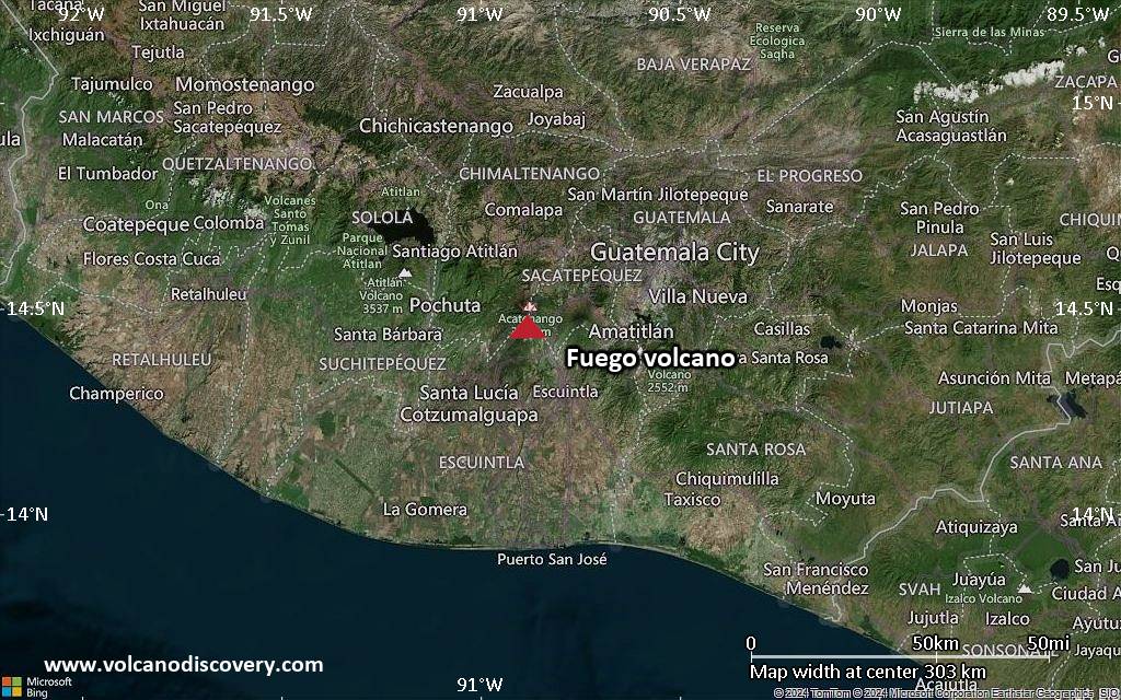
<!–div style="font-size:14px;text-align:center;border:3px solid blue;border-radius:5px;padding:3px;margin:5px;background:#eee"><a href="https://www.volcanoesandearthquakes.com/app/volcano-report.php?volcanoId=26" style="text-decoration:none" target="_blank" rel="noopener noreferrer nofollow" title="Share a volcano (activity) report, submit a photo or other interesting news!” onclick=”window.open(this.href,’Volcano Report’,’status=0,toolbar=0,location=0,directories=0,menubar=0,resizable=1,scrollbars=1,height=500,width=450′);return false”>Send Volcano Report</div–> Stratovolcano 3,763 m / 12,346 ft
Guatemala, 14.47°N / -90.88°W
Current status: erupting (4 out of 5) Fuego volcano eruptions:
1581, 1585, 1586, 1587, 1614, 1617, 1620, 1623, 1629, 1679(?), 1685, 1686, 1689(?), 1699, 1702, 1705, 1706, 1709(?), 1710,1717,1730, 1732, 1737, 1751(?), 1765(?), 1773(?), 1799, 1826, 1829, 1850(?), 1852(?), 1855, 1856, 1857, 1860, 1861(?), 1867(?), 1880, 1896, 1932, 1944, 1949, 1953, 1955, 1957, 1962, 1963, 1966, 1967, 1971, 1973, 1974, 1975, 1977, 1987, 1999, 2002 – ongoing
Typical eruption style
Dominantly explosive, construction of lava domes and extrusion of viscous lava flows. In near constant activity, at least during the past centuries.

Click this link to continue reading the article on the source website.

RSS feed source: Volcano Discovery.com--Global earthquake monitor

Date and TimeMag
DepthDistanceLocationDetailsMap Aug 26, 05:41 pm (Merida)

4.0

70 km52 km (32 mi) to the S North Pacific Ocean, 49 km south of Mapastepec, Estado de Chiapas, MexicoI FELT IT InfoAug 26, 04:46 pm (GMT -6)

4.3

58 km96 km (60 mi) to the NW North Pacific Ocean, 41 km southwest of Tonala, Estado de Chiapas, MexicoI FELT IT InfoAug 24, 03:34 am (GMT -6)

3.6

105 km54 km (34 mi) to the SE 27 km west of Huixtla, Estado de Chiapas, MexicoI FELT IT

Info

Aug 24, 03:19 am (Merida)

4.2

89 km47 km (29 mi) to the SE 39 km west of Huixtla, Estado de Chiapas, MexicoI FELT IT InfoAug 22, 11:09 pm (Merida)

4.3

90 km18 km (11 mi) to the NW 22 km southwest of Pijijiapan, Estado de Chiapas, MexicoI FELT IT InfoAug 22, 05:28 am (Mexico City)

4.1

84 km91 km (56 mi) to the NW North Pacific Ocean, 38 km southwest of Tonala, Estado de Chiapas, MexicoI FELT IT InfoAug 9, 2023 03:33 am (Mexico City)

5.8

104 km99 km (61 mi) to the NW 2.9 km southwest of Tonala, Estado de Chiapas, Mexico 140 reportsInfoJun 23, 2020 03:29 pm (Universal Time)

7.1

10 km296 km (184 mi) to the W 62 km west of Salina Cruz, Estado de Oaxaca, Mexico 469 reportsInfoSep 7, 2017 10:49 pm (GMT -6)

8.0

60 km85 km (53 mi) to the SW North Pacific Ocean, 87 km southwest of Topon, Estado de Chiapas, Mexico 317 reportsInfoDec 17, 2015 01:49 pm (Merida)

6.4

90 km60 km (37 mi) to the N Near Coast of Chiapas,

Click this link to continue reading the article on the source website.

RSS feed source: Volcano Discovery.com--Global earthquake monitor

Date and TimeMag
DepthDistanceLocationDetailsMap Aug 21, 10:38 am (GMT +7)

3.3

20 km27 km (17 mi) to the SW Indian Ocean, 68 km south of Pelabuhanratu, IndonesiaI FELT IT1 report

Info

Aug 20, 03:35 am (GMT +7)

3.6

10 km64 km (40 mi) to the S Indian Ocean, 105 km southwest of Banjar, Indonesia

Info

Aug 19, 05:29 pm (GMT +7)

3.1

22 km65 km (40 mi) to the SE Indian Ocean, 92 km southwest of Banjar, Indonesia

Info

Aug 17, 01:33 pm (Jakarta)

3.0

34 km14 km (9 mi) to the S Indian Ocean, 60 km south of Pelabuhanratu, Indonesia

Info

Aug 15, 12:35 am (Jakarta)

4.2

27 km26 km (16 mi) to the SE Indian Ocean, 72 km southwest of Banjar, Indonesia InfoAug 13, 08:32 am (Jakarta)

4.8

32 km51 km (32 mi) to the SE Indian Ocean, 61 km southwest of Banjar, Indonesia 7 reportsInfoJul 31, 10:45 pm (GMT +7)

4.2

63 km89 km (55 mi) to the W Indian Ocean, Banten, 73 km southwest of Pelabuhanratu, Indonesia InfoJul 26, 09:53 pm (Jakarta)

4.5

148 km77 km (48 mi) to the N Java, Indonesia 1 reportInfoJul 20, 11:47 am (GMT +7)

4.4

18 km38 km (24 mi) to the SW Java, Indonesia 2 reportsInfoFeb 25, 2024 08:07 pm (GMT +7)

6.0

29 km100 km (62 mi) to the W Java, Indonesia 43 reportsInfoDec 8, 2022 07:50 am (Jakarta)

5.8

107 km85 km (53 mi) to the NE 17 km northwest of Ciranjang-hilir, Kabupaten Cianjur, Jawa Barat, Indonesia 49 reportsInfoDec 3, 2022 04:49 pm (Jakarta)

6.4

118 km84 km (52 mi) to the E Indonesia: Di Darat 52 Km BaratDaya Kab-Garut 42 reportsInfoNov 21, 2022 01:21 pm (Jakarta)

5.6

10 km68 km (42 mi) to the NE Di

Click this link to continue reading the article on the source website.