RSS feed source: Volcano Discovery.com--Global earthquake monitor

97 km (60 mi)

N of epicenter

Yarada

(pop: 3,410)

II: Very weak

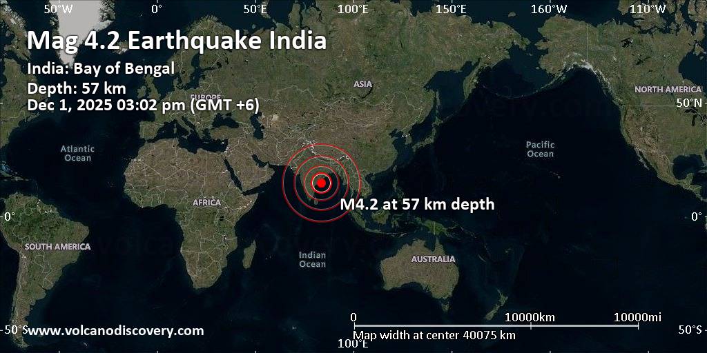
Vishakhapatnam, State of Andhra Pradesh 102 km (63 mi)

NW of epicenter

Visakhapatnam

(pop: 1,063,200)

II: Very weak

Vishakhapatnam, State of Andhra Pradesh 104 km (64 mi)

NW of epicenter

Gajuwaka

(pop: 258,900)

II: Very weak

Vishakhapatnam, State of Andhra Pradesh 104 km (64 mi)

N of epicenter

Rasapudipalem

(pop: 1,728,100)

II: Very weak

Vishakhapatnam, State of Andhra Pradesh 111 km (69 mi)

NW of epicenter

Elamanchili

(pop: 27,300)

II: Very weak

Anakapalli, State of Andhra Pradesh 112 km (69 mi)

N of epicenter

Vepagunta

(pop: 26,900)

II: Very weak

Vishakhapatnam, State of Andhra Pradesh 113 km (70 mi)

NW of epicenter

Anakapalle

(pop: 86,500)

II: Very weak

Anakapalli, State of Andhra Pradesh 118 km (73 mi)

N of epicenter

Bhimunipatnam

(pop: 55,100)

II: Very weak

Vishakhapatnam, State of Andhra Pradesh 123 km (77 mi)

NW of epicenter

Payakaraopeta

(pop: 27,000)

II: Very weak

Anakapalli, State of Andhra Pradesh 125 km (78 mi)

NW of epicenter

Tuni

(pop: 53,400)

II: Very weak

Kakinada, State of Andhra Pradesh 130 km (81 mi)

NW of epicenter

Chodavaram

(pop: 29,000)

II: Very weak

Anakapalli, State of Andhra Pradesh 139 km (86 mi)

NW of epicenter

Narsipatnam

(pop: 33,800)

II: Very weak

Anakapalli, State

Click this link to continue reading the article on the source website.

RSS feed source: Volcano Discovery.com--Global earthquake monitor

<!–div style="font-size:14px;text-align:center;border:3px solid blue;border-radius:5px;padding:3px;margin:5px;background:#eee"><a href="https://www.volcanoesandearthquakes.com/app/volcano-report.php?volcanoId=2868" style="text-decoration:none" target="_blank" rel="noopener noreferrer nofollow" title="Share a volcano (activity) report, submit a photo or other interesting news!” onclick=”window.open(this.href,’Volcano Report’,’status=0,toolbar=0,location=0,directories=0,menubar=0,resizable=1,scrollbars=1,height=500,width=450′);return false”>Send Volcano Report</div–> caldera 635 m / 2,083 ft
Nicaragua, 11.98°N / -86.16°W
Current status: erupting (4 out of 5) Masaya volcano eruptions:
2012, 2008, 2006, 2005, 2004 (?), 2003, 2001, 1999-2000, 1998, 1997, 1996, 1993-94, 1989, 1987, 1965-85, 1948, 1946-47, 1925, 1919-24, 1918, 1913, 1906, 1904, 1902-03, 1858-59, 1858 (?), 1856-57, 1853, 1852, 1772, 1670, 1613 (?), 1586, 1570, 1551, 1524-44
Tephrochronology and radiocarbon-dated: 150 AD, 170 BC ± 100 years, 4050 BC
Typical eruption style
effusive, sometimes lava lakes, strombolian activity

Click this link to continue reading the article on the source website.

RSS feed source: Volcano Discovery.com--Global earthquake monitor

Date and TimeMag
DepthDistanceLocationDetailsMap Dec 1, 06:40 am (Port Moresby)

4.3

10 km32 km (20 mi) to the NE 27 km south of Aitape, West Sepik Province, Papua New GuineaI FELT IT InfoOct 10, 06:10 am (Port Moresby)

4.6

35 km21 km (13 mi) to the S 76 km southwest of Aitape, West Sepik Province, Papua New Guinea InfoSep 25, 12:53 am (Port Moresby)

5.0

118 km78 km (48 mi) to the SE West Sepik Province, 42 km west of Ambunti, Papua New Guinea InfoSep 14, 01:05 am (Port Moresby)

4.9

109 km62 km (39 mi) to the S 89 km west of Ambunti, East Sepik Province, Papua New Guinea InfoSep 10, 09:14 pm (Port Moresby)

4.2

47 km65 km (40 mi) to the NE Bismarck Sea, 108 km west of Kairiru Island, Papua New Guinea InfoJul 6, 06:21 pm (Port Moresby)

5.3

108 km58 km (36 mi) to the S 197 km west of Wewak, East Sepik Province, Papua New Guinea 1 reportInfoMar 21, 03:25 pm (Port Moresby)

4.9

117 km55 km (34 mi) to the S 200 km west of Wewak, East Sepik Province, Papua New Guinea InfoFeb 17, 07:02 am (Port Moresby)

4.7

220 km122 km (76 mi) to the E Bismarck Sea, 57 km west of Wewak, East Sepik Province, Papua New Guinea InfoMay 3, 2023 06:09 am (Port Moresby)

5.5

120 km92 km (57 mi) to the SE 17 km northwest of Ambunti, East Sepik Province, Papua New Guinea 5 reportsInfoApr 9, 2023 12:11 am (Port Moresby)

5.3

70 km65 km (40 mi) to the N South Pacific Ocean, 47 km west of Aitape, West Sepik Province,

Click this link to continue reading the article on the source website.

RSS feed source: Volcano Discovery.com--Global earthquake monitor

Date and TimeMag
DepthDistanceLocationDetailsMap Nov 29, 03:02 pm (GMT -6)

3.0

14 km50 km (31 mi) to the S North Pacific Ocean, 88 km southwest of San Isidro, Costa RicaI FELT IT

Info

Nov 29, 10:35 am (GMT -6)

3.0

9 km70 km (44 mi) to the S North Pacific Ocean, 152 km south of San Jose, Provincia de San Jose, Costa RicaI FELT IT

Info

Nov 28, 07:37 pm (GMT -6)

3.3

3 km62 km (39 mi) to the S North Pacific Ocean, 99 km southwest of San Isidro, Costa RicaI FELT IT3 reportsInfoNov 28, 09:15 am (Universal Time)

3.3

7 km75 km (47 mi) to the NW North Pacific Ocean, 49 km south of Puntarenas, Costa RicaI FELT IT

Info

Nov 27, 03:38 pm (GMT -6)

3.0

10 km52 km (33 mi) to the S North Pacific Ocean, 84 km southwest of San Isidro, Costa RicaI FELT IT

Info

Nov 24, 08:48 pm (GMT -6)

4.4

10 km51 km (32 mi) to the S North Pacific Ocean, Provincia de Puntarenas, 129 km south of San Jose, Costa RicaI FELT IT2 reportsInfoNov 22, 01:57 pm (GMT -6)

4.1

10 km60 km (37 mi) to the S North Pacific Ocean, 92 km southwest of San Isidro, Costa Rica 1 reportInfoNov 22, 01:39 pm (Costa Rica)

4.1

5 km30 km (19 mi) to the E North Pacific Ocean, 42 km southwest of San Isidro, Costa Rica 1 reportInfoNov 22, 01:39 pm (GMT -6)

4.4

1 km62 km (38 mi) to the S North Pacific Ocean, 115 km west of Golfito, Provincia de Puntarenas,

Click this link to continue reading the article on the source website.