RSS feed source: Volcano Discovery.com

<!–div style="font-size:14px;text-align:center;border:3px solid blue;border-radius:5px;padding:3px;margin:5px;background:#eee"><a href="https://www.volcanoesandearthquakes.com/app/volcano-report.php?volcanoId=114" style="text-decoration:none" target="_blank" rel="noopener noreferrer nofollow" title="Share a volcano (activity) report, submit a photo or other interesting news!” onclick=”window.open(this.href,’Volcano Report’,’status=0,toolbar=0,location=0,directories=0,menubar=0,resizable=1,scrollbars=1,height=500,width=450′);return false”>Send Volcano Report</div–> Stratovolcano 2708 m (8,884 ft)
Costa Rica, 10.2°N / -84.23°W
Current status: erupting (4 out of 5) Poas volcano eruptions:
1828, 1834, 1838(?), 1860, 1879(?), 1880, 1888-91, 1895, 1898-1907, 1910, 1910, 1914, 1914-15, 1925, 1929, 1941-46, 1948-51, 1952-57, 1958-61, 1963, 1964-65, 1967, 1969, 1970, 1972-73, 1974-75, 1976, 1977, 1977-78, 1978, 1979-80, 1980, 1981, 1987-90, 1991, 1992, 1992-93, 1994, 1996, 2010, 2011, 2012, 2013, 2014, 2016, 2017, 2025
Typical eruption style
Phreatic eruptions, sometimes geyser-like ejections of water from the acid crater lake.

Click this link to continue reading the article on the source website.

RSS feed source: Volcano Discovery.com

<!–div style="font-size:14px;text-align:center;border:3px solid blue;border-radius:5px;padding:3px;margin:5px;background:#eee"><a href="https://www.volcanoesandearthquakes.com/app/volcano-report.php?volcanoId=16" style="text-decoration:none" target="_blank" rel="noopener noreferrer nofollow" title="Share a volcano (activity) report, submit a photo or other interesting news!” onclick=”window.open(this.href,’Volcano Report’,’status=0,toolbar=0,location=0,directories=0,menubar=0,resizable=1,scrollbars=1,height=500,width=450′);return false”>Send Volcano Report</div–> Complex stratovolcano Currently 3,369 m / 11,053 ft (changing due to eruptive activity and collapse of its crater rims)
Sicily, Italy, 37.75°N / 14.99°E
Current status: erupting (4 out of 5) Etna volcano eruptions:
Near continuously active; some major historic eruptions include 122 BC (large Plinian outbursts that created the small caldera of the “Cratere del Piano”), 1669 AD (devastating flank eruption that destroyed 15 villages and part of Catania), 1787 (Subplinian eruption and one of the most spectacular summit eruptions on record – lava fountains reportedly up to 3000 m high).
Eruptions since 1950 (f: flank / s: summit activity): 1950 (s), 1950-51(f), 1955 (s), 1956 (s), 1956 (f), 1957 (s),1960 (s), 1961 (s), 1964 (f), 1964 (s), 1966

Click this link to continue reading the article on the source website.
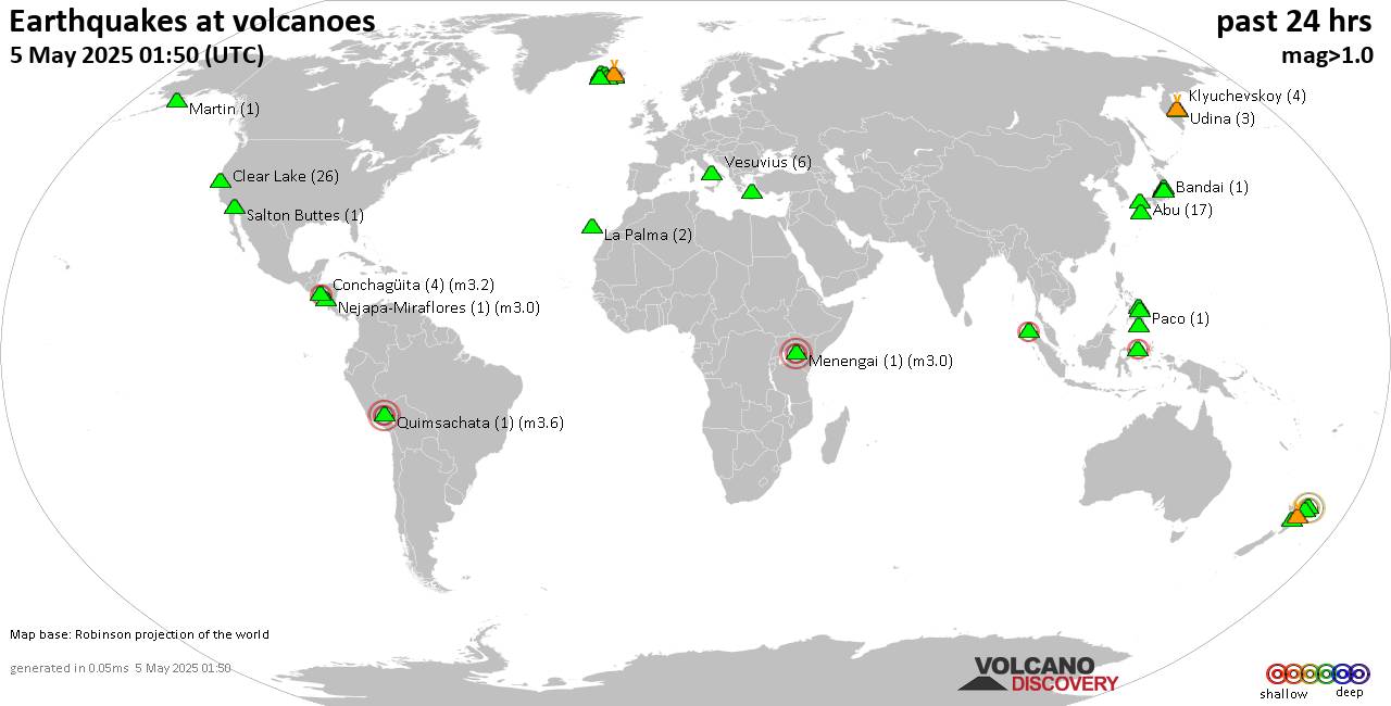
RSS feed source: Volcano Discovery.com

Mon, 5 May 2025, 15:50 | BY: EARTHQUAKEMONITOR

World map showing volcanoes with shallow (less than 50 km) earthquakes within 20 km radius during the past 24 hours on 5 May 2025 Number in brackets indicate nr of quakes.

Quakes detected near: Abu (14 quakes between mag 0.1-1.0), Akagi (1 quake mag 1.4), Ambang (1 quake mag 2.3), Askja (1 quake mag 1.3), Bandai (1 quake mag 1.3), Bardarbunga (10 quakes between mag 0.4-3.0)
Biliran (1 quake mag 2.1), Cabalian (1 quake mag 1.6), Canlaon (1 quake mag 1.5), Clear Lake (22 quakes between mag 0.2-2.2), Conchagüita (4 quakes between mag 2.0-3.2), Cosigüina (1 quake mag 2.5), Coso (2 quakes between mag 1.2-1.3), Fagradalsfjall (6 quakes between mag 0.3-1.1), Golden Trout Creek (1 quake mag 3.0), Guagua Pichincha (1 quake mag 3.0), Hekla (1 quake mag 1.0), Hiuchi (5 quakes between mag 0.2-1.1), Hrómundartindur (3 quakes between mag 0.4-1.0), Irazu (1 quake mag 2.0), Iya (1 quake mag 2.4), Kirishima (2 quakes between mag 0.7-1.3), Klyuchevskoy (3 quakes between mag 1.2-1.5), Kolumbo (12 quakes between mag 0.8-2.2), Krísuvík (3 quakes between mag 0.2-1.2), Ljósufjöll (15 quakes between mag 0.1-3.1), Los Atlixcos (1 quake mag 3.2), Marapi (1 quake mag 2.0), Martin (1 quake mag 1.4), Miravalles (1 quake mag 2.2), Paco (1 quake mag 2.1), Parker (1 quake mag 1.6), Peuet Sague (1 quake

Click this link to continue reading the article on the source website.

RSS feed source: Volcano Discovery.com

Date and TimeMag
DepthDistanceLocationDetailsMap Mar 8, 01:57 am (GMT +11)

4.3

35 km39 km (24 mi) to the SW Coral Sea, 76 km southwest of Anatom Island, Tafea, Vanuatu InfoFeb 20, 07:16 pm (GMT +11)

4.6

10 km57 km (35 mi) to the E South Pacific Ocean, 60 km southeast of Anatom Island, Tafea, Vanuatu InfoFeb 13, 11:18 pm (GMT +11)

4.9

10 km78 km (49 mi) to the W 124 km SSW of Isangel, Vanuatu InfoJan 17, 12:27 am (GMT +11)

5.0

36 km61 km (38 mi) to the SW Coral Sea, 98 km southwest of Anatom Island, Tafea, Vanuatu 1 reportInfoJan 1, 03:52 pm (GMT +11)

4.3

10 km77 km (48 mi) to the SW Coral Sea, 114 km southwest of Anatom Island, Tafea, Vanuatu InfoDec 7, 2023 11:56 pm (GMT +11)

7.1

48 km35 km (22 mi) to the SW Vanuatu 29 reportsInfoSep 14, 2022 10:04 pm (GMT +11)

7.0

137 km105 km (65 mi) to the SE 209 km SSE of Isangel, Vanuatu 28 reportsInfoMar 31, 2022 04:44 pm (GMT +11)

7.0

10 km248 km (154 mi) to the S Southeast of the Loyalty Islands 2 reportsInfoDec 5, 2018 03:18 pm (GMT +11)

7.4

10 km160 km (99 mi) to the S Southeast of Loyalty Islands 44 reportsInfoAug 29, 2018 02:51 pm (GMT +11)

7.1

21 km182 km (113 mi) to the S South Pacific Ocean, 238 km east of Tadine, Loyalty Islands, New Caledonia 3 reportsInfoNov 20, 2017 09:43 am (GMT +11)

7.0

10 km130 km (81 mi) to the SW Loyalty Islands 26 reportsInfoSep 4, 2011 09:55 am (GMT +11)

7.0

185 km25 km (15 mi) to the SE 133 km SSE of Isangel, Vanuatu InfoAug 21,

Click this link to continue reading the article on the source website.