RSS feed source: Volcano Discovery.com--Global earthquake monitor

9 km (6 mi)

W of epicenter

El Suchil

(pop: 699)

II: Very weak

Jesus Carranza, Estado de Veracruz-Llave 15 km (9 mi)

S of epicenter

Suchilapan del Rio

(pop: 2,490)

II: Very weak

Jesus Carranza, Estado de Veracruz-Llave 20 km (12 mi)

NW of epicenter

Medias Aguas

(pop: 1,120)

II: Very weak

Sayula de Aleman, Estado de Veracruz-Llave 21 km (13 mi)

W of epicenter

El Paraiso

(pop: 1,070)

II: Very weak

Jesus Carranza, Estado de Veracruz-Llave 24 km (15 mi)

E of epicenter

Vicente Guerrero

(pop: 1,200)

II: Very weak

Hidalgotitlan, Estado de Veracruz-Llave 25 km (15 mi)

NE of epicenter

Venustiano Carranza (Pena Blanca)

(pop: 1,100)

II: Very weak

Texistepec, Estado de Veracruz-Llave 27 km (17 mi)

SW of epicenter

Los Angeles

(pop: 1,140)

II: Very weak

Matias Romero Avendano, Estado de Oaxaca 32 km (20 mi)

NW of epicenter

Achotal de Moreno

(pop: 1,510)

II: Very weak

San Juan Evangelista, Estado de Veracruz-Llave 33 km (21 mi)

S of epicenter

Donaji

(pop: 2,360)

II: Very weak

Matias Romero Avendano, Estado de Oaxaca 33 km (21 mi)

NE of epicenter

San Lorenzo Tenochtitlan

(pop: 1,040)

II: Very weak

Texistepec, Estado de Veracruz-Llave 34 km (21 mi)

W of epicenter

El Porvenir

(pop: 1,580)

II: Very weak

San Juan Cotzocon, Estado de

Click this link to continue reading the article on the source website.

RSS feed source: Volcano Discovery.com--Global earthquake monitor

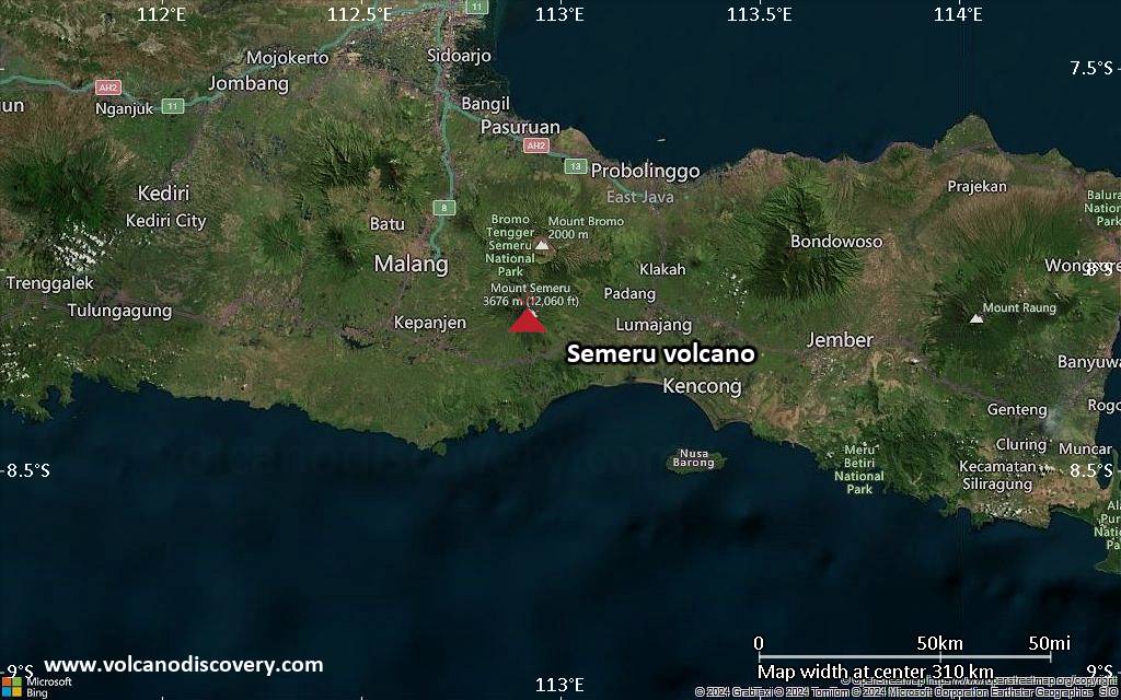
<!–div style="font-size:14px;text-align:center;border:3px solid blue;border-radius:5px;padding:3px;margin:5px;background:#eee"><a href="https://www.volcanoesandearthquakes.com/app/volcano-report.php?volcanoId=44" style="text-decoration:none" target="_blank" rel="noopener noreferrer nofollow" title="Share a volcano (activity) report, submit a photo or other interesting news!” onclick=”window.open(this.href,’Volcano Report’,’status=0,toolbar=0,location=0,directories=0,menubar=0,resizable=1,scrollbars=1,height=500,width=450′);return false”>Send Volcano Report</div–> Stratovolcano 3676 m (12,060 ft)
East Java, Indonesia, -8.11°S / 112.92°E
Current status: erupting (4 out of 5) Semeru volcano eruptions:
1818, 1829, 1830, 1832, 1836, 1838, 1842, 1844, 1845, 1848, 1849(?), 1851, 1856, 1857, 1865, 1866(?), 1887, 1887, 1888, 1889-91, 1892, 1893, 1893-94, 1895, 1896, 1897, 1899, 1899, 1900, 1901, 1903, 1904, 1905, 1907, 1908, 1909-10, 1910-11, 1911, 1912, 1913, 1941-42, 1945, 1946, 1946-47, 1950-64, 1967-ongoing
Typical eruption style
Explosive. Near constant strombolian activity, occasionally stronger explosions, lava flows and pyroclastic flows.

Click this link to continue reading the article on the source website.
RSS feed source: Volcano Discovery.com--Global earthquake monitor

Date and TimeMag
DepthDistanceLocationDetailsMap May 10, 12:36 pm (GMT -6)

4.6

67 km27 km (17 mi) to the SE55 km SW of Puerto El Triunfo, El Salvador  I FELT IT3 reportsInfoMay 8, 11:26 am (GMT -6)

4.1

42 km51 km (31 mi) to the SE North Pacific Ocean, 74 km south of Usulutan, El SalvadorI FELT IT1 reportInfoMay 4, 12:17 pm (GMT -6)

4.0

10 km84 km (52 mi) to the S North Pacific Ocean, 160 km south of San Salvador, El Salvador InfoMay 1, 01:03 am (GMT -6)

4.2

44 km53 km (33 mi) to the W North Pacific Ocean, 71 km southwest of San Salvador, El Salvador 3 reportsInfoApr 28, 10:22 am (GMT -6)

4.3

23 km45 km (28 mi) to the W North Pacific Ocean, 79 km south of Santa Tecla, El Salvador 3 reportsInfoJan 9, 10:31 am (El Salvador)

5.8

95 km99 km (62 mi) to the NW 13 km south of Sonsonate, Departamento de Sonsonate, El Salvador 91 reportsInfoJan 5, 11:18 am (GMT -6)

6.2

46 km16 km (9.7 mi) to the W North Pacific Ocean, 77 km south of San Salvador, El Salvador 188 reportsInfoAug 28, 2024 03:57 pm (GMT -6)

6.1

26 km59 km (37 mi) to the W North Pacific Ocean, 83 km southwest of San Salvador, El Salvador 99 reportsInfoJul 30, 2019 11:54 pm (El Salvador)

5.8

77 km45 km (28 mi) to the N North Pacific Ocean, 19 km southeast of La Libertad, El Salvador 124 reportsInfoMay 30, 2019 03:03 am (GMT -6)

6.6

58 km36 km (22 mi) to the NW North Pacific Ocean, 32 km south

Click this link to continue reading the article on the source website.

RSS feed source: Volcano Discovery.com--Global earthquake monitor

Wed, 14 May 2025, 22:34 | BY: EARTHQUAKEMONITOR

The United States Geological Survey reported a magnitude 3.6 quake in the United States near Anchorage, Alaska, only 3 minutes ago. The earthquake hit early afternoon on Wednesday, May 14th, 2025, at 2:30 pm local time at an intermediate depth of 49 miles. The exact magnitude, epicenter, and depth of the quake might be revised within the next few hours or minutes as seismologists review data and refine their calculations, or as other agencies issue their report.
Our monitoring service identified a second report from The Incorporated Research Institutions for Seismology (IRIS) which listed the quake at magnitude 3.6 as well. A third agency, the European-Mediterranean Seismological Centre (EMSC), reported the same quake at magnitude 3.6.
According to preliminary calculations, we do not expect that the quake was felt by many people and did not cause any damage. In Beluga (pop. 20, 25 miles away), Big Lake (pop. 3,400, 44 miles away), Anchorage (pop. 291,200, 49 miles away), and Knik-Fairview (pop. 14,900, 56 miles away), the quake was probably not felt.

If you felt it, report it through our site or app right now!

Download and Upgrade the Volcanoes & Earthquakes app to get one of the fastest seismic alerts online:
Android | IOS
Earthquake data:

I felt this quake

Date & time: May 14, 2025 02:30 pm (GMT -8) local time

Click this link to continue reading the article on the source website.