RSS feed source: Federal Emergency Management Agency

FRANKFORT, Ky. – Today is the last day for Kentucky homeowners and renters who suffered uninsured damage to their property from the May 16-17 tornadoes to apply for federal disaster assistance. 

The application deadline is 11:59 p.m. tonight, August 22.

Eligible counties are Caldwell, Laurel, Pulaski, Russell, Trigg and Union.

Survivors are encouraged to file insurance claims for damage to their homes, personal property and vehicles before they apply for FEMA assistance. FEMA Individual Assistance cannot duplicate insurance benefits or other sources of assistance. 

How To Apply for FEMA Assistance

There are several ways to apply for FEMA assistance:Online at DisasterAssistance.gov.Visit any Disaster Recovery Center. To find a center close to you, visit fema.gov/DRC, or text DRC along with your Zip Code to 43362 (Example: “DRC 29169”).Use the FEMA mobile app.Call the FEMA Helpline at 800-621-3362. Help is available in many languages. If you use a relay service, such as Video Relay Service (VRS), captioned telephone or other service, give FEMA your number for that service. When you apply, you will need to provide:A current phone number where you can be contacted.A current email address.Your address at the time of the disaster and the address where you are now staying.Your Social Security Number. A general list of damage and losses.Banking information if you choose direct deposit.  If insured, the policy number or the agent and/or the company name.

Survivors should keep their contact

Click this link to continue reading the article on the source website.

RSS feed source: Federal Emergency Management Agency

Date and TimeMag
DepthDistanceLocationDetailsMap Jul 4, 12:39 pm (Makassar)

4.0

10 km92 km (57 mi) to the NW Kabupaten Luwu Timur, 132 km east of Palopo, Indonesia 1 reportInfoJun 19, 11:48 am (Makassar)

4.1

8 km35 km (22 mi) to the E Banda Sea, Sulawesi Tengah, 66 km north of Pulau Labengke Island, Indonesia 1 reportInfoApr 20, 08:36 am (Makassar)

4.6

13 km28 km (17 mi) to the NE Banda Sea, Sulawesi Tengah, 86 km north of Pulau Meong Island, Indonesia InfoMay 31, 2024 01:08 am (Makassar)

5.1

10 km29 km (18 mi) to the NE Sulawesi, Indonesia 4 reportsInfoMay 14, 2024 09:41 pm (Makassar)

4.6

10 km37 km (23 mi) to the N155 km NNW of Kendari, Indonesia InfoJun 28, 2023 01:03 pm (Makassar)

4.6

7 km40 km (25 mi) to the E Indonesia: Di Laut 19 Km Timur Laut Lafeu Kab.Morowali InfoMar 5, 2023 01:05 am (Makassar)

4.5

38 km40 km (25 mi) to the N Kabupaten Morowali Utara, Sulawesi Tengah, 164 km northwest of Kendari, Indonesia 3 reportsInfoJul 30, 2022 12:31 am (Makassar)

5.5

10 km93 km (58 mi) to the NE Banda Sea, 171 km north of Kendari, Kota Kendari, Southeast Sulawesi, Indonesia 3 reportsInfoJan 3, 2021 07:14 pm (Universal Time)

5.0

10 km22 km (14 mi) to the NE Morowali Regency, 137 km north of Kendari, Indonesia 1 reportInfoDec 17, 2017 10:31 am (Makassar)

5.0

10 km38 km (23 mi) to the NE Banda Sea, Sulawesi Tengah, 137 km north of Kendari, Indonesia InfoMay 24, 2017 05:10 pm (Makassar)

5.5

11 km30 km (18 mi) to the NE Banda Sea, 41 km northwest of Pulau Waruwaru Island, Sulawesi Tengah, Indonesia InfoApr 13, 2016

Click this link to continue reading the article on the source website.

RSS feed source: Federal Emergency Management Agency

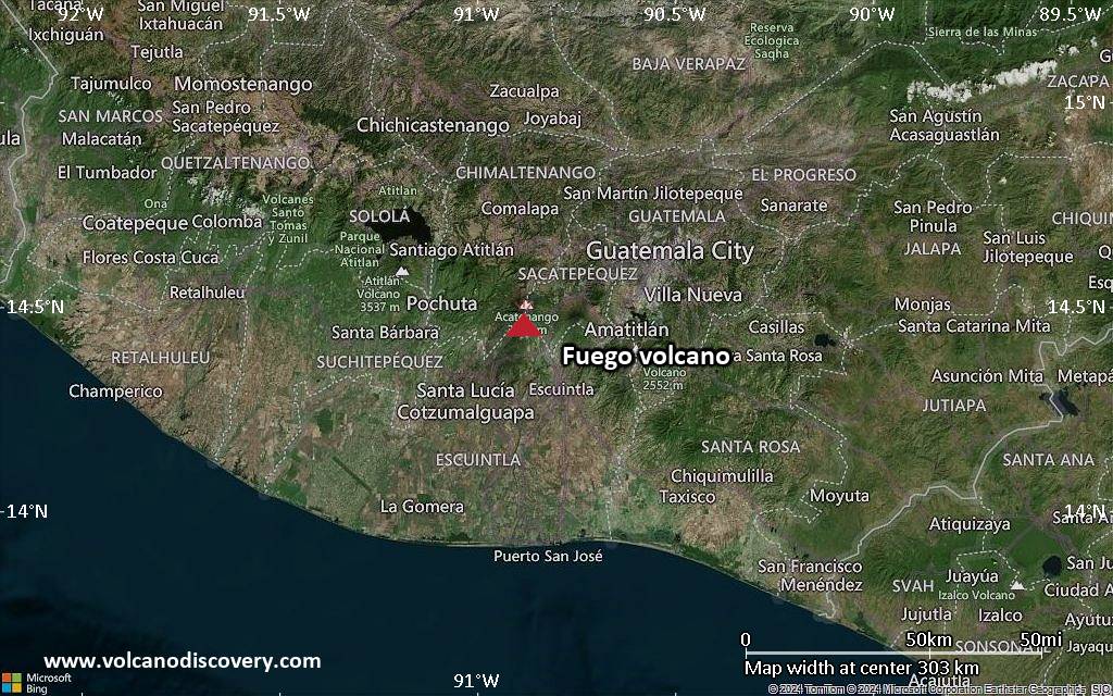
<!–div style="font-size:14px;text-align:center;border:3px solid blue;border-radius:5px;padding:3px;margin:5px;background:#eee"><a href="https://www.volcanoesandearthquakes.com/app/volcano-report.php?volcanoId=26" style="text-decoration:none" target="_blank" rel="noopener noreferrer nofollow" title="Share a volcano (activity) report, submit a photo or other interesting news!” onclick=”window.open(this.href,’Volcano Report’,’status=0,toolbar=0,location=0,directories=0,menubar=0,resizable=1,scrollbars=1,height=500,width=450′);return false”>Send Volcano Report</div–> Stratovolcano 3,763 m / 12,346 ft
Guatemala, 14.47°N / -90.88°W
Current status: erupting (4 out of 5) Fuego volcano eruptions:
1581, 1585, 1586, 1587, 1614, 1617, 1620, 1623, 1629, 1679(?), 1685, 1686, 1689(?), 1699, 1702, 1705, 1706, 1709(?), 1710,1717,1730, 1732, 1737, 1751(?), 1765(?), 1773(?), 1799, 1826, 1829, 1850(?), 1852(?), 1855, 1856, 1857, 1860, 1861(?), 1867(?), 1880, 1896, 1932, 1944, 1949, 1953, 1955, 1957, 1962, 1963, 1966, 1967, 1971, 1973, 1974, 1975, 1977, 1987, 1999, 2002 – ongoing
Typical eruption style
Dominantly explosive, construction of lava domes and extrusion of viscous lava flows. In near constant activity, at least during the past centuries.

Click this link to continue reading the article on the source website.
RSS feed source: Federal Emergency Management Agency

Fri, 22 Aug 2025, 12:13 | BY: EARTHQUAKEMONITOR

A magnitude 3.6 earthquake near Oia, Kykládes, South Aegean, Greece, was reported only 16 minutes ago by the National Observatory of Athens (NOA), considered the main national agency that monitors seismic activity in Greece. The earthquake occurred at a very shallow depth of 5. km beneath the epicenter early afternoon on Friday, August 22nd, 2025, at 2:55 pm local time. The exact magnitude, epicenter, and depth of the quake might be revised within the next few hours or minutes as seismologists review data and refine their calculations, or as other agencies issue their report.
Our monitoring service identified a second report from the Kandilli Oservatory and Earthquake Research Institute in Istanbul (KOERI-RETMC) which listed the quake at magnitude 3.6 as well. Other agencies reporting the same quake include the European-Mediterranean Seismological Centre (EMSC) at magnitude 4.1, The Aristotle University of Thessaloniki Geophysical Lab. (AUTH) at magnitude 3.5, and The Seismological Laboratory of the University of Athens (UOA) at magnitude 3.6.
Based on the preliminary seismic data, the quake should not have caused any significant damage, but was probably felt by many people as light vibration in the area of the epicenter.
Weak shaking might have been felt in Kalotaritissa (pop. 20) located 14 km from the epicenter.
Other towns or cities near the epicenter where the quake

Click this link to continue reading the article on the source website.