RSS feed source: USGS Earthquake Hazards Program
Time2025-11-12 19:08:54 UTC2025-11-12 19:08:54 UTC at epicenterLocation39.414°N 143.412°EDepth10.00 km (6.21 mi)
Click this link to continue reading the article on the source website.
RSS feed source: USGS Earthquake Hazards Program
Time2025-11-12 19:08:54 UTC2025-11-12 19:08:54 UTC at epicenterLocation39.414°N 143.412°EDepth10.00 km (6.21 mi)
Click this link to continue reading the article on the source website.
RSS feed source: USGS Earthquake Hazards Program
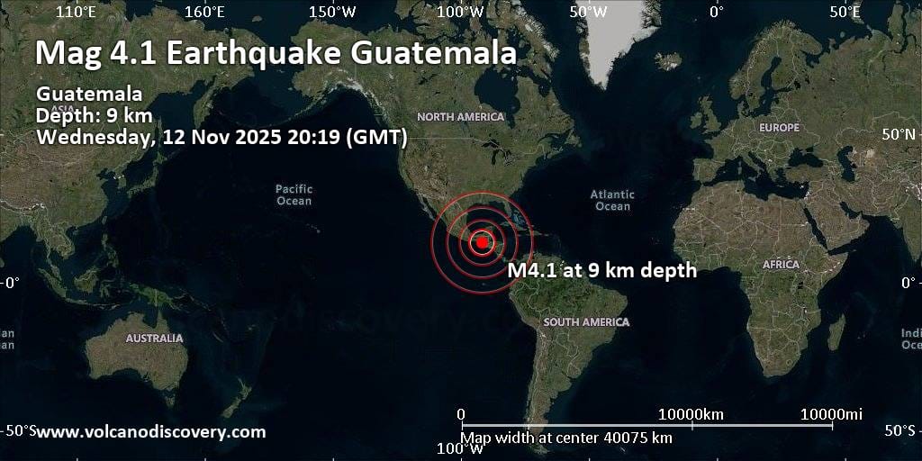
Wednesday, Nov 12, 2025 20:40 | 1 hour ago | By: EarthquakeMonitor
The European-Mediterranean Seismological Centre (EMSC) reported a magnitude 2.7 quake in Cyprus near Paphos, Pafos, only 16 minutes ago. The earthquake hit late at night on Wednesday, November 12th, 2025, at 10:23 pm local time at a shallow depth of 15.60 km. The exact magnitude, epicenter, and depth of the quake might be revised within the next few hours or minutes as seismologists review data and refine their calculations, or as other agencies issue their report.
Our monitoring service identified a second report from the citizen-seismograph network of RaspberryShake which listed the quake at magnitude 2.7 as well.
Towns or cities near the epicenter where the quake might have been felt as very weak shaking include Acheleia (pop. 120) located 9 km from the epicenter. In Geroskipou (pop. 8,400, 10 km away), Paphos (pop. 36,000, 12 km away), Konia (pop. 2,200, 13 km away), Chlorakas (pop. 6,400, 15 km away), Emba (pop. 5,500, 16 km away), Mesogi (pop. 1,700, 17 km away), Kissonerga (pop. 2,000, 18 km away), and Tala (pop. 1,700, 19 km away), the quake was probably not felt.
If you felt it, report it through our site or app right now!
Download and Upgrade the Volcanoes & Earthquakes app to get one of the fastest seismic alerts online:
Android | IOS
Earthquake
Click this link to continue reading the article on the source website.
RSS feed source: USGS Earthquake Hazards Program
<!–div style="font-size:14px;text-align:center;border:3px solid blue;border-radius:5px;padding:3px;margin:5px;background:#eee"><a href="https://www.volcanoesandearthquakes.com/app/volcano-report.php?volcanoId=26" style="text-decoration:none" target="_blank" rel="noopener noreferrer nofollow" title="Share a volcano (activity) report, submit a photo or other interesting news!” onclick=”window.open(this.href,’Volcano Report’,’status=0,toolbar=0,location=0,directories=0,menubar=0,resizable=1,scrollbars=1,height=500,width=450′);return false”>Send Volcano Report</div–> Stratovolcano 3,763 m / 12,346 ft
Guatemala, 14.47°N / -90.88°W
Current status: erupting (4 out of 5) Fuego volcano eruptions:
1581, 1585, 1586, 1587, 1614, 1617, 1620, 1623, 1629, 1679(?), 1685, 1686, 1689(?), 1699, 1702, 1705, 1706, 1709(?), 1710,1717,1730, 1732, 1737, 1751(?), 1765(?), 1773(?), 1799, 1826, 1829, 1850(?), 1852(?), 1855, 1856, 1857, 1860, 1861(?), 1867(?), 1880, 1896, 1932, 1944, 1949, 1953, 1955, 1957, 1962, 1963, 1966, 1967, 1971, 1973, 1974, 1975, 1977, 1987, 1999, 2002 – ongoing
Typical eruption style
Dominantly explosive, construction of lava domes and extrusion of viscous lava flows. In near constant activity, at least during the past centuries.
Click this link to continue reading the article on the source website.
RSS feed source: USGS Earthquake Hazards Program
6 km (4 mi)
NW of epicenter
(pop: 1,310)
IV: Light
Municipio de San Sebastian Huehuetenango, Departamento de Huehuetenango 12 km (8 mi)
E of epicenter
(pop: 79,400)
IV: Light
Departamento de Huehuetenango 18 km (11 mi)
N of epicenter
(pop: 3,290)
IV: Light
Municipio de Todos Santos Cuchumatan, Departamento de Huehuetenango 19 km (12 mi)
NW of epicenter
(pop: 3,020)
IV: Light
Departamento de Huehuetenango 20 km (12 mi)
SW of epicenter
(pop: 3,660)
III: Weak
Departamento de San Marcos 22 km (13 mi)
W of epicenter
(pop: 3,710)
III: Weak
San Ildefonso Ixtahuacan, Departamento de Huehuetenango 29 km (18 mi)
E of epicenter
(pop: 5,570)
III: Weak
Municipio de Aguacatan, Departamento de Huehuetenango 31 km (19 mi)
SW of epicenter
(pop: 6,010)
III: Weak
Departamento de San Marcos 31 km (20 mi)
S of epicenter
(pop: 23,000)
III: Weak
Departamento de Quetzaltenango 34 km (21 mi)
SW of epicenter
(pop: 59,500)
III: Weak
Departamento de San Marcos 36 km (22 mi)
NW of epicenter
(pop: 6,440)
III: Weak
Departamento de Huehuetenango 38 km (24 mi)
NE of epicenter
(pop: 49,000)
III: Weak
Departamento de Huehuetenango 38 km
Click this link to continue reading the article on the source website.