RSS feed source: Volcano Discovery.com

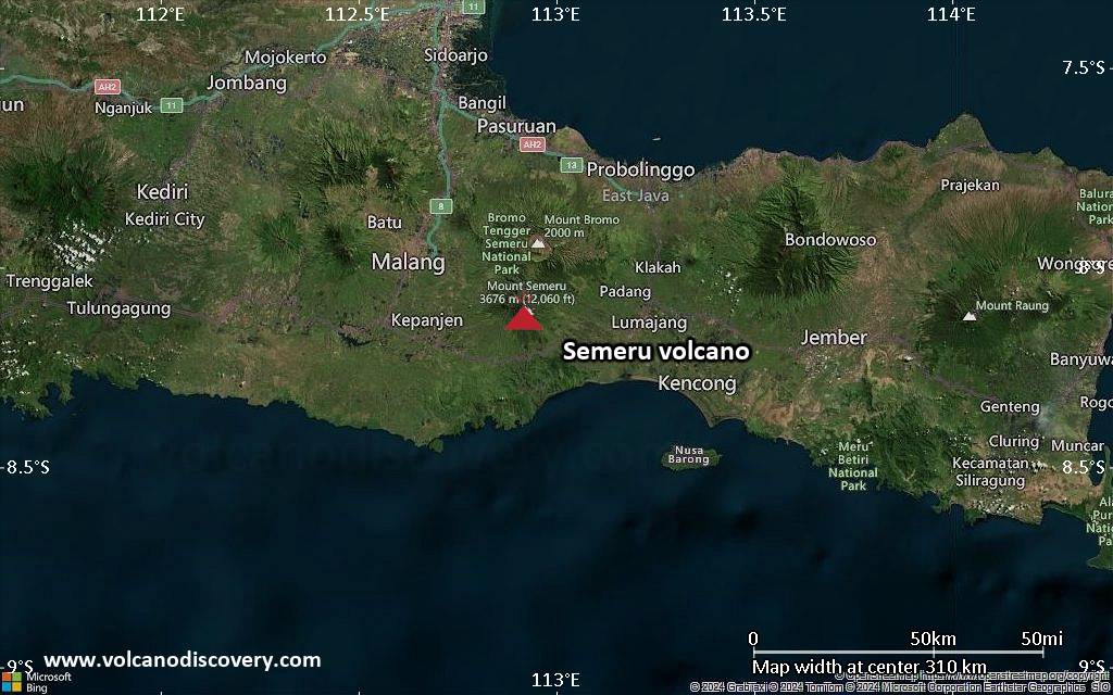
<!–div style="font-size:14px;text-align:center;border:3px solid blue;border-radius:5px;padding:3px;margin:5px;background:#eee"><a href="https://www.volcanoesandearthquakes.com/app/volcano-report.php?volcanoId=44" style="text-decoration:none" target="_blank" rel="noopener noreferrer nofollow" title="Share a volcano (activity) report, submit a photo or other interesting news!” onclick=”window.open(this.href,’Volcano Report’,’status=0,toolbar=0,location=0,directories=0,menubar=0,resizable=1,scrollbars=1,height=500,width=450′);return false”>Send Volcano Report</div–> Stratovolcano 3676 m (12,060 ft)
East Java, Indonesia, -8.11°S / 112.92°E
Current status: erupting (4 out of 5) Semeru volcano eruptions:
1818, 1829, 1830, 1832, 1836, 1838, 1842, 1844, 1845, 1848, 1849(?), 1851, 1856, 1857, 1865, 1866(?), 1887, 1887, 1888, 1889-91, 1892, 1893, 1893-94, 1895, 1896, 1897, 1899, 1899, 1900, 1901, 1903, 1904, 1905, 1907, 1908, 1909-10, 1910-11, 1911, 1912, 1913, 1941-42, 1945, 1946, 1946-47, 1950-64, 1967-ongoing
Typical eruption style
Explosive. Near constant strombolian activity, occasionally stronger explosions, lava flows and pyroclastic flows.

Click this link to continue reading the article on the source website.
RSS feed source: Volcano Discovery.com

Tue, 8 Apr 2025, 15:43 | BY: EARTHQUAKEMONITOR

Indonesia’s Meteorology, Climatology, and Geophysical Agency reported a magnitude 2.8 quake in Indonesia near Mataram, Kota Mataram, West Nusa Tenggara, only 24 minutes ago. The earthquake hit late at night on Tuesday, April 8th, 2025, at 11:18 pm local time at a shallow depth of 17. km. The exact magnitude, epicenter, and depth of the quake might be revised within the next few hours or minutes as seismologists review data and refine their calculations, or as other agencies issue their report.
A second report was later issued by the European-Mediterranean Seismological Centre (EMSC), which listed it as a magnitude 2.8 earthquake as well.
Towns or cities near the epicenter where the quake might have been felt as very weak shaking include Senggigi (pop. 5,000) located 5 km from the epicenter, and Mataram (pop. 429,700) 8 km away. In Gili Air (pop. 1,800, 19 km away), Lembar (pop. 10,000, 22 km away), Praya (pop. 35,200, 29 km away), Karangasem (pop. 31,900, 51 km away), Amlapura (pop. 31,900, 51 km away), Amlapura (pop. 31,900, 52 km away), and Selong (pop. 92,500, 53 km away), the quake was probably not felt.

If you felt it, report it through our site or app right now!

Download and Upgrade the Volcanoes & Earthquakes app to get one of the fastest seismic alerts online:
Android

Click this link to continue reading the article on the source website.

RSS feed source: Volcano Discovery.com

Tue, 8 Apr 2025, 15:34 | BY: EARTHQUAKEMONITOR

An earthquake of magnitude 5.6 occurred after midnight on Wednesday, April 9th, 2025, at 12:26 am local time near Yonakuni, Yaeyama-gun, Okinawa, Japan, as reported by the German Research Centre for Geosciences (GFZ).
According to preliminary data, the quake was located at an intermediate depth of 115. km. The strength of the earthquake may have been tempered by its relative great depth below the surface, which makes it feel weaker in absolute terms. The exact magnitude, epicenter, and depth of the quake might be revised within the next few hours or minutes as seismologists review data and refine their calculations, or as other agencies issue their report.
A second report was later issued by the citizen-seismograph network of RaspberryShake, which listed it as a magnitude 5.6 earthquake as well. A third agency, the European-Mediterranean Seismological Centre (EMSC), reported the same quake at magnitude 5.6.
Based on the preliminary seismic data, the quake should not have caused any significant damage, but was probably felt by many people as light vibration in the area of the epicenter.
Weak shaking might have been felt in Yonakuni (pop. 1,700) located 33 km from the epicenter, and Ishigaki (pop. 44,800) 107 km away.
VolcanoDiscovery will automatically update magnitude and depth if these change and follow up if other significant news about the quake

Click this link to continue reading the article on the source website.

RSS feed source: Volcano Discovery.com

Date and TimeMag
DepthDistanceLocationDetailsMap Mar 15, 12:04 am (GMT +9)

4.2

162 km61 km (38 mi) to the W 7.1 km southeast of Shibata, Niigata, Japan InfoMar 10, 09:52 am (GMT +9)

4.1

166 km87 km (54 mi) to the NW Japan Sea (East Sea), 70 km north of Niigata, Niigata, Japan InfoMar 1, 10:17 pm (GMT +9)

4.5

10 km97 km (61 mi) to the NE 22 km east of Shinjo, Yamagata, Japan 1 reportInfoOct 12, 2024 07:35 am (GMT +9)

4.5

104 km71 km (44 mi) to the SE 21 km W of Minami-Sōma, Japan 1 reportInfoAug 2, 2024 01:28 am (GMT +9)

4.1

106 km81 km (50 mi) to the E13 km ESE of Watari, Japan InfoJan 1, 2024 04:10 pm (GMT +9)

7.5

10 km253 km (157 mi) to the W Ishikawa, 85 km north of Takaoka, Toyama, Japan 191 reportsInfoJul 30, 2023 01:33 am (GMT +9)

4.3

196 km88 km (55 mi) to the NW Japan Sea (East Sea), 41 km southwest of Tsuruoka, Yamagata, Japan InfoMay 8, 2023 11:04 am (GMT +9)

4.2

127 km91 km (57 mi) to the S 20 km west of Shirakawa, Fukushima, Japan InfoMar 16, 2022 11:36 pm (GMT +9)

7.3

41 km136 km (84 mi) to the E 57 km ENE of Namie, Japan 101 reportsInfoFeb 13, 2021 11:07 pm (GMT +9)

7.0

56 km138 km (86 mi) to the E Near East Coast of Honshu, Japan 472 reportsInfoSep 7, 2019 12:09 am (Universal Time)

5.1

10 km96 km (60 mi) to the N Japan Sea (East Sea), 12 km northwest of Tsuruoka, Yamagata, Japan InfoJun 18, 2019 10:22 pm (GMT +9)

6.4

20 km94 km (59 mi) to the NW

Click this link to continue reading the article on the source website.