RSS feed source: USGS Earthquake Hazards Program
Time2025-04-12 07:30:56 UTC2025-04-12 07:30:56 UTC at epicenterLocation33.809°N 72.556°EDepth39.21 km (24.36 mi)
Click this link to continue reading the article on the source website.
RSS feed source: USGS Earthquake Hazards Program
Time2025-04-12 07:30:56 UTC2025-04-12 07:30:56 UTC at epicenterLocation33.809°N 72.556°EDepth39.21 km (24.36 mi)
Click this link to continue reading the article on the source website.
RSS feed source: USGS Earthquake Hazards Program
Support us – Help us upgrade our services! We truly love working to bring you the latest volcano and earthquake data from around the world. Maintaining our website and our free apps does require, however, considerable time and resources.
We need financing to increase hard- and software capacity as well as support our editor team. We’re aiming to achieve uninterrupted service wherever an earthquake or volcano eruption unfolds, and your donations can make it happen! Every donation will be highly appreciated. If you find the information useful and would like to support our team in integrating further features, write great content, and in upgrading our soft- and hardware, please make a donation (PayPal).
Planned features:
Improved multilanguage supportTsunami alertsFaster responsivenessThanks to your past donations, these features have been added recently:Design upgradeDetailed quake statsAdditional seismic data sourcesDownload and Upgrade the Volcanoes & Earthquakes app to get one of
Click this link to continue reading the article on the source website.
RSS feed source: USGS Earthquake Hazards Program
Date and TimeMag
DepthDistanceLocationDetailsMap Apr 7, 2021 03:32 am (GMT +2)
3.9
74 km60 km (37 mi) to the NE Eastern Mediterranean, 197 km north of Marsá Maţrūḩ, Egypt
Info
Apr 28, 2020 01:01 pm (Universal Time)
4.2
10 km54 km (34 mi) to the NE193 km N of Mersa Matruh, Egypt InfoOct 9, 2017 12:14 am (GMT +2)
4.6
40 km36 km (23 mi) to the NE Eastern Mediterranean, 484 km northwest of Cairo, Cairo, Egypt 1 reportInfoMar 24, 2017 03:45 am (GMT +2)
3.1
22 km93 km (58 mi) to the NE GIRIT ADASI ACIKLARI (MEDITERRANEAN SEA)
Info
Mar 17, 2016 08:25 pm (GMT +2)
3.8
6.9 km88 km (55 mi) to the NE Eastern Mediterranean, 490 km northwest of Cairo, Cairo, Egypt
Info
Aug 21, 2015 04:44 am (Universal Time)
3.6
29 km96 km (60 mi) to the W Eastern Mediterranean, 183 km northwest of Marsá Maţrūḩ, Egypt
Info
Aug 17, 2015 07:49 am (GMT +2)
4.2
10 km85 km (53 mi) to the NE Eastern Mediterranean Sea InfoJun 22, 2015 01:28 am (Universal Time)
3.6
35 km90 km (56 mi) to the NEEastern Mediterranean
Info
Jun 22, 2015 01:26 am (Universal Time)
3.7
35 km78 km (49 mi) to the NE Eastern Mediterranean Sea
Info
Jun 21, 2015 06:24 pm (Universal Time)
3.5
35 km95 km (59 mi) to the NEEastern Mediterranean
Info
Apr 17, 2015 11:48 am (Universal Time)
3.9
35 km82 km (51 mi) to the NE Eastern Mediterranean Sea
Info
Dec 8, 2013 12:12 am (Universal Time)
3.3
17 km97 km (60 mi) to the NE Eastern Mediterranean Sea
Info
Nov 10, 2013 03:19 am (GMT +2)
3.3
23 km94 km (58 mi) to the NE Eastern Mediterranean, 312 km southeast of Irakleion, Greece
Info
Feb 14, 2013 08:16 am (Universal
Click this link to continue reading the article on the source website.
RSS feed source: USGS Earthquake Hazards Program
Sat, 12 Apr 2025, 07:50 | BY: EARTHQUAKEMONITOR
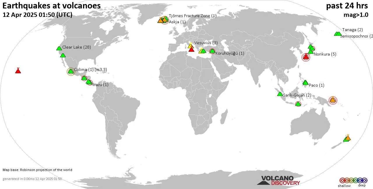
World map showing volcanoes with shallow (less than 50 km) earthquakes within 20 km radius during the past 24 hours on 12 Apr 2025 Number in brackets indicate nr of quakes.
Quakes detected near: Abu (15 quakes between mag 0.1-1.4), Apaneca Range (6 quakes between mag 1.7-2.8), Askja (1 quake mag 1.4), Bardarbunga (9 quakes between mag 0.2-3.0), Brennisteinsfjöll (12 quakes between mag 0.4-1.4), Buzzard Creek (1 quake mag 1.1)
Cabalian (1 quake mag 1.9), Campi Flegrei (Phlegrean Fields) (27 quakes between mag 0.1-3.0), Clear Lake (29 quakes between mag 0.0-1.3), Colima (1 quake mag 3.3), Eldey (1 quake mag 2.2), Eyafjallajökull (2 quakes between mag 1.8-1.8), Fagradalsfjall (17 quakes between mag 0.5-1.6), Guagua Pichincha (1 quake mag 3.5), Hengill (1 quake mag 1.1), Irazu (1 quake mag 2.4), Kawah Kamojang (1 quake mag 2.8), Kilauea (1 quake mag 1.7), Kolumbo (36 quakes between mag 1.1-2.4), Koruhüyüğü (1 quake mag 2.4), Krísuvík (9 quakes between mag 0.2-1.1), Kurikoma (5 quakes between mag 0.3-2.8), Ljósufjöll (1 quake mag 1.0), Loki-Fögrufjöll volcano (6 quakes between mag 0.1-1.7), Maunaloa (1 quake mag 1.6), Milos (1 quake mag 2.2), Miravalles (1 quake mag 2.0), Norikura (4 quakes between mag 0.1-1.0), Paco (1 quake mag 1.5), Puyehue-Cordón Caulle (1 quake mag 2.6), Salton Buttes (2 quakes between mag 1.1-1.2), Santorini (1
Click this link to continue reading the article on the source website.