RSS feed source: Volcano Discovery.com--Global earthquake monitor

Date and TimeMag
DepthDistanceLocationDetailsMap Apr 3, 08:31 pm (GMT +10)

4.6

92 km22 km (14 mi) to the NE South Pacific Ocean, 61 km southwest of Ambitle Island, Papua New Guinea InfoApr 1, 08:25 am (Port Moresby)

4.5

57 km7.5 km (4.6 mi) to the W Papua New Guinea InfoFeb 19, 05:15 pm (Universal Time)

4.7

70 km73 km (46 mi) to the NW 75 km ENE of Kokopo, Papua New Guinea InfoFeb 18, 12:13 pm (Universal Time)

4.7

10 km48 km (30 mi) to the NW New Ireland Province, 87 km east of Kokopo, Papua New Guinea InfoJan 30, 06:03 am (GMT +10)

4.9

77 km80 km (50 mi) to the S 172 km SE of Kokopo, Papua New Guinea InfoNov 15, 2024 03:28 pm (GMT +10)

6.6

56 km7.8 km (4.8 mi) to the SE South Pacific Ocean, 83 km southwest of Ambitle Island, Papua New Guinea 5 reportsInfoOct 14, 2022 08:20 am (GMT +10)

6.4

72 km41 km (25 mi) to the E 155 km ESE of Kokopo, Papua New Guinea 5 reportsInfoMay 14, 2019 10:58 pm (Port Moresby)

7.4

25 km101 km (63 mi) to the NW New Britain Region, P.N.G. 40 reportsInfoMar 9, 2018 03:39 am (Port Moresby)

6.8

23 km38 km (24 mi) to the N South Pacific Ocean, 57 km southwest of Ambitle Island, Papua New Guinea 4 reportsInfoJul 13, 2017 01:36 pm (Port Moresby)

6.4

43 km19 km (12 mi) to the W South Pacific Ocean, 25 km east of Wallis Island, Papua New Guinea InfoJan 22, 2017 03:30 pm (Bougainville)

7.8

156 km256 km (159 mi) to the SE 60 km west of Arawa, Bougainville, Papua New Guinea 5

Click this link to continue reading the article on the source website.

RSS feed source: Volcano Discovery.com--Global earthquake monitor

Sat, 12 Apr 2025, 03:31 | BY: EARTHQUAKEMONITOR

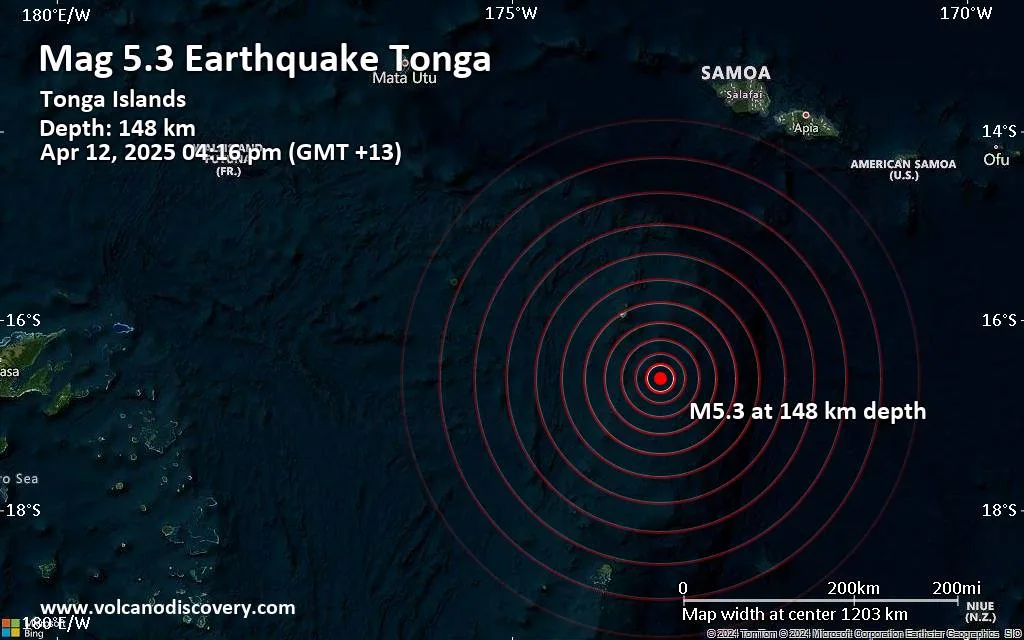
The German Research Centre for Geosciences (GFZ) reported a magnitude 5.3 quake in Tonga near Vaipoa, Niuas, only 13 minutes ago. The earthquake hit in the afternoon on Saturday, April 12th, 2025, at 4:16 pm local time at an intermediate depth of 148. km. The exact magnitude, epicenter, and depth of the quake might be revised within the next few hours or minutes as seismologists review data and refine their calculations, or as other agencies issue their report.
A second report was later issued by the citizen-seismograph network of RaspberryShake, which listed it as a magnitude 5.3 earthquake as well. A third agency, the European-Mediterranean Seismological Centre (EMSC), reported the same quake at magnitude 5.4.
Based on the preliminary seismic data, the quake should not have caused any significant damage, but was probably felt by many people as light vibration in the area of the epicenter.
Weak shaking might have been felt in Vaipoa (pop. 170) located 87 km from the epicenter, and Hihifo (pop. 820) 87 km away.
VolcanoDiscovery will automatically update magnitude and depth if these change and follow up if other significant news about the quake become available. If you’re in the area, please send us your experience through our reporting mechanism, either online or via our mobile app. This will help us provide

Click this link to continue reading the article on the source website.
RSS feed source: Volcano Discovery.com--Global earthquake monitor

Date and TimeMag
DepthDistanceLocationDetailsMap Aug 21, 2024 02:23 am (Panama)

4.3

1 km59 km (37 mi) to the N North Pacific Ocean, 61 km south of Santiago, Provincia de Veraguas, Panama 6 reportsInfoApr 18, 2024 05:02 pm (Panama)

4.2

2.9 km95 km (59 mi) to the E 9.1 km southwest of Tonosi, Los Santos, Panama 1 reportInfoApr 8, 2024 12:29 pm (Panama)

4.6

0 km60 km (37 mi) to the NW 89 km southwest of Sona, Provincia de Veraguas, Panama 1 reportInfoMar 12, 2024 08:50 am (Panama)

4.0

1 km59 km (37 mi) to the N North Pacific Ocean, 78 km southwest of Santiago, Provincia de Veraguas, Panama 2 reportsInfoFeb 20, 2024 03:22 am (Panama)

4.4

1 km83 km (52 mi) to the NE Provincia de Herrera, 47 km south of Santiago, Provincia de Veraguas, Panama InfoFeb 6, 2024 11:56 am (Panama)

4.1

1 km85 km (53 mi) to the E 19 km southwest of Tonosi, Los Santos, Panama InfoDec 24, 2021 04:58 pm (Panama)

4.9

10 km123 km (76 mi) to the NW 42 km SSE of Boca Chica, Panama InfoJul 15, 2020 04:39 pm (Panama)

5.5

10 km76 km (47 mi) to the NW 72 km southwest of Sona, Provincia de Veraguas, Panama 43 reportsInfoApr 20, 2020 11:52 pm (Panama)

4.9

10 km49 km (30 mi) to the NE 93 km south of Santiago de Veraguas, Santiago, Provincia de Veraguas, Panama 46 reportsInfoJun 13, 2018 06:54 pm (Panama)

5.1

10 km87 km (54 mi) to the E 24 km west of Bucaro, Los Santos, Panama 105 reportsInfoAug 17, 2016 11:22 am (Panama)

4.8

2 km107 km (67 mi) to the NW North Pacific Ocean, 63 km

Click this link to continue reading the article on the source website.

RSS feed source: Volcano Discovery.com--Global earthquake monitor

…The Flood Warning continues for the following rivers in Arkansas… White River At Newport affecting Jackson and Independence Counties. White River At Des Arc affecting Prairie County. White River At Georgetown affecting Prairie, White and Woodruff Counties. White River At Clarendon affecting Arkansas and Monroe Counties. White River At Augusta affecting White and Woodruff Counties. For the Lower White River…including Newport, Augusta, Georgetown, Des Arc, Clarendon…Major flooding is forecast. * WHAT…Moderate flooding is occurring and moderate flooding is forecast. * WHERE…White River at Augusta. * WHEN…Until further notice. * IMPACTS…At 36.0 feet, Major flood level begins. Areas along Taylor Bay flooded. Some homes flooded at this level. * ADDITIONAL DETAILS… –

Click this link to continue reading the article on the source website.