RSS feed source: Volcano Discovery.com

<!–div style="font-size:14px;text-align:center;border:3px solid blue;border-radius:5px;padding:3px;margin:5px;background:#eee"><a href="https://www.volcanoesandearthquakes.com/app/volcano-report.php?volcanoId=26" style="text-decoration:none" target="_blank" rel="noopener noreferrer nofollow" title="Share a volcano (activity) report, submit a photo or other interesting news!” onclick=”window.open(this.href,’Volcano Report’,’status=0,toolbar=0,location=0,directories=0,menubar=0,resizable=1,scrollbars=1,height=500,width=450′);return false”>Send Volcano Report</div–> Stratovolcano 3,763 m / 12,346 ft
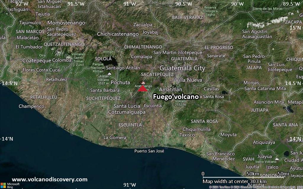
Guatemala, 14.47°N / -90.88°W
Current status: erupting (4 out of 5) Fuego volcano eruptions:
1581, 1585, 1586, 1587, 1614, 1617, 1620, 1623, 1629, 1679(?), 1685, 1686, 1689(?), 1699, 1702, 1705, 1706, 1709(?), 1710,1717,1730, 1732, 1737, 1751(?), 1765(?), 1773(?), 1799, 1826, 1829, 1850(?), 1852(?), 1855, 1856, 1857, 1860, 1861(?), 1867(?), 1880, 1896, 1932, 1944, 1949, 1953, 1955, 1957, 1962, 1963, 1966, 1967, 1971, 1973, 1974, 1975, 1977, 1987, 1999, 2002 – ongoing
Typical eruption style
Dominantly explosive, construction of lava domes and extrusion of viscous lava flows. In near constant activity, at least during the past centuries.

Click this link to continue reading the article on the source website.
RSS feed source: Volcano Discovery.com

Date and TimeMag
DepthDistanceLocationDetailsMap Aug 12, 07:28 pm (Merida)

4.1

152 km96 km (59 mi) to the NE 39 km northwest of Cintalapa de Figueroa, Estado de Chiapas, MexicoI FELT IT InfoAug 11, 09:15 pm (Merida)

4.0

162 km87 km (54 mi) to the NE 20 km northwest of Cintalapa de Figueroa, Estado de Chiapas, MexicoI FELT IT InfoAug 11, 07:58 am (GMT -6)

4.3

45 km69 km (43 mi) to the S North Pacific Ocean, 70 km southeast of Salina Cruz, Estado de Oaxaca, MexicoI FELT IT InfoAug 9, 06:25 am (Mexico City)

4.0

114 km89 km (55 mi) to the NW 7.2 km northwest of Matias Romero, Estado de Oaxaca, MexicoI FELT IT InfoAug 8, 03:02 pm (Mexico City)

4.0

110 km74 km (46 mi) to the NW 7.9 km southeast of Matias Romero, Estado de Oaxaca, MexicoI FELT IT InfoAug 7, 01:20 am (Mexico City)

4.2

9.8 km43 km (27 mi) to the N 56 km northeast of Juchitan de Zaragoza, Estado de Oaxaca, MexicoI FELT IT InfoAug 4, 05:16 am (GMT -6)

4.2

36 km92 km (57 mi) to the S North Pacific Ocean, 90 km southeast of Salina Cruz, Estado de Oaxaca, MexicoI FELT IT InfoAug 1, 05:08 am (Mexico City)

4.3

97 km18 km (11 mi) to the NW Oaxaca, Mexico InfoOct 6, 2023 11:06 pm (Mexico City)

6.0

110 km93 km (58 mi) to the NW 12 km northwest of Matias Romero, Estado de Oaxaca, Mexico 127 reportsInfoAug 9, 2023 03:33 am (Mexico City)

5.8

104 km84 km (52 mi) to the E 2.9 km southwest of Tonala, Estado

Click this link to continue reading the article on the source website.

RSS feed source: Volcano Discovery.com

Date and TimeMag
DepthDistanceLocationDetailsMap Jul 19, 10:51 pm (GMT +9)

4.1

10 km34 km (21 mi) to the SE Banda Sea, 56 km west of Pulau Namsar Island, Maluku, Indonesia InfoJul 18, 05:31 am (GMT +9)

4.0

85 km69 km (43 mi) to the SW Banda Sea, 134 km northwest of Pulau Molu Island, Maluku, Indonesia InfoJul 17, 02:47 am (GMT +9)

4.2

63 km96 km (60 mi) to the S Banda Sea, 74 km northwest of Pulau Molu Island, Maluku, Indonesia InfoJun 29, 01:51 am (GMT +9)

4.1

78 km33 km (21 mi) to the NE Banda Sea, 44 km south of Pulau Teor Island, Maluku, Indonesia InfoJun 6, 09:37 am (GMT +9)

4.3

134 km68 km (42 mi) to the SW Banda Sea, 203 km west of Tual, Kota Tual, Maluku, Indonesia InfoNov 11, 2024 07:08 pm (Jayapura)

5.0

23 km92 km (57 mi) to the NE Banda Sea, 103 km northwest of Tual, Kota Tual, Maluku, Indonesia InfoNov 11, 2024 07:35 am (Jayapura)

5.0

66 km94 km (58 mi) to the NE Ceram Sea, 120 km northwest of Tual, Kota Tual, Maluku, Indonesia InfoJul 22, 2024 11:47 pm (GMT +9)

5.2

73 km14 km (8.6 mi) to the NW Banda Sea, 175 km west of Tual, Kota Tual, Maluku, Indonesia InfoNov 8, 2023 01:53 pm (GMT +9)

7.1

6 km236 km (147 mi) to the SW Banda Sea, 166 km north of Pulau Wetan Island, Maluku, Indonesia InfoAug 10, 2023 11:00 am (GMT +9)

5.2

87 km56 km (35 mi) to the S Banda Sea, 143 km west of Tual, Kota Tual, Maluku, Indonesia 1 reportInfoMar 26, 2023 09:41 pm

Click this link to continue reading the article on the source website.