RSS feed source: Volcano Discovery.com--Global earthquake monitor

Date and TimeMag
DepthDistanceLocationDetailsMap Nov 20, 08:15 am (Makassar)

4.8

10 km5.6 km (3.5 mi) to the SW Kabupaten Parigi Moutong, 174 km north of Palu, IndonesiaI FELT IT InfoSep 2, 01:01 pm (Makassar)

4.1

65 km26 km (16 mi) to the SE 168 km northeast of Palu, Kota Palu, Sulawesi Tengah, Indonesia InfoJul 27, 11:21 am (Makassar)

4.3

58 km79 km (49 mi) to the E 203 km northeast of Palu, Kota Palu, Sulawesi Tengah, Indonesia InfoApr 25, 02:09 pm (Makassar)

4.5

10 km10.1 km (6.3 mi) to the E Kabupaten Parigi Moutong, 187 km northeast of Palu, Indonesia InfoMar 22, 11:46 am (Makassar)

4.1

5 km73 km (45 mi) to the NW Makassar Strait, 32 km west of Pulau Simatang Island, Sulawesi Tengah, Indonesia InfoMar 14, 07:13 pm (Makassar)

5.4

21 km70 km (43 mi) to the N Makassar Strait, 19 km northwest of Pulau Simatang Island, Indonesia InfoJan 28, 10:53 pm (Makassar)

5.8

76 km81 km (51 mi) to the E Kabupaten Parigi Moutong, 219 km northeast of Palu, Indonesia 16 reportsInfoOct 20, 2024 01:24 pm (Makassar)

4.8

88 km69 km (43 mi) to the SE 187 km northeast of Palu, Kota Palu, Sulawesi Tengah, Indonesia InfoOct 20, 2024 02:07 am (Makassar)

5.5

35 km71 km (44 mi) to the W Makassar Strait, 81 km southwest of Pulau Simatang Island, Indonesia InfoMar 25, 2021 05:23 am (Makassar)

5.2

576 km71 km (44 mi) to the NE Kabupaten Toli-Toli, 248 km northeast of Palu, Indonesia InfoOct 9, 2018 05:15 am (Makassar)

5.1

10 km87 km (54 mi) to the SW Kabupaten Parigi Moutong, 100 km north of Palu, Indonesia 2 reportsInfoSep 28, 2018 06:14 pm

Click this link to continue reading the article on the source website.

RSS feed source: Volcano Discovery.com--Global earthquake monitor

Date and TimeMag
DepthDistanceLocationDetailsMap Nov 5, 05:25 pm (Bogota)

3.5

57 km98 km (61 mi) to the N Tiquisio (Puerto Rico) – Bolívar, Colombia

Info

Oct 27, 04:17 pm (Bogota)

3.2

67 km81 km (50 mi) to the N 27 km southeast of Tiquisio, Departamento de Bolivar, Colombia 1 report

Info

Oct 1, 04:55 pm (Bogota)

3.3

179 km74 km (46 mi) to the NE Aguachica – Cesar, Colombia

Info

Sep 29, 10:44 am (Bogota)

3.4

116 km78 km (49 mi) to the E 49 km northwest of Bucaramanga, Departamento de Santander, Colombia

Info

Sep 6, 04:42 am (Bogota)

3.1

131 km91 km (56 mi) to the E El Playón – Santander, Colombia 1 report

Info

May 11, 05:41 am (Bogota)

4.6

97 km35 km (22 mi) to the SE 6.1 km east of Puerto Wilches, Departamento de Santander, Colombia 9 reportsInfoJan 19, 01:28 am (Bogota)

4.5

75 km84 km (52 mi) to the W 7 km S of El Bagre, Colombia 6 reportsInfoMay 11, 2024 12:25 pm (Bogota)

4.2

71 km90 km (56 mi) to the W 6.3 km west of San Carlos, Antioquia, Colombia 1 reportInfoMar 30, 2023 03:24 am (Bogota)

4.5

63 km89 km (56 mi) to the W 15 km north of San Carlos, Antioquia, Colombia 8 reportsInfoNov 27, 2022 11:47 am (Bogota)

4.4

140 km91 km (57 mi) to the E 44 km north of Bucaramanga, Departamento de Santander, Colombia InfoSep 17, 2022 01:12 am (Bogota)

4.3

109 km41 km (26 mi) to the SE 42 km north of Barrancabermeja, Departamento de Santander, Colombia 2 reportsInfoJun 8, 2022 06:12 pm (Bogota)

4.6

92 km89 km (55 mi) to the S Antioquia, 44 km southwest of Barrancabermeja, Colombia 10 reportsInfoFeb 23, 2022 07:49 am (Bogota)

5.5

51 km32 km (20 mi)

Click this link to continue reading the article on the source website.
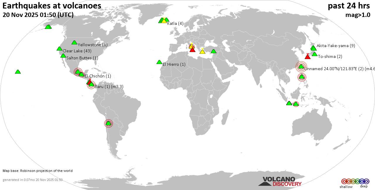
RSS feed source: Volcano Discovery.com--Global earthquake monitor

Thursday, Nov 20, 2025 00:50 | 51 mins ago | By: EarthquakeMonitor

World map showing volcanoes with shallow (less than 50 km) earthquakes within 20 km radius during the past 24 hours on 20 Nov 2025 Number in brackets indicate nr of quakes.

Quakes detected near: Akita-Yake-yama (9 quakes between mag 0.2-1.1), Askja (3 quakes between mag 0.8-1.7), Baluran (1 quake mag 2.7), Baru (1 quake mag 3.3), Campi Flegrei (Phlegrean Fields) (50 quakes between mag 0.1-2.7), Clear Lake (42 quakes between mag 0.2-2.3)
Cofre de Perote (3 quakes between mag 2.6-3.2), El Chichón (2 quakes between mag 2.3-2.4), El Hierro (1 quake mag 1.2), Eldey (79 quakes between mag 0.5-2.8), Etna (1 quake mag 1.6), Irazu (1 quake mag 2.1), Katla (4 quakes between mag 0.3-1.2), Kawah Kamojang (1 quake mag 1.8), Kirishima (4 quakes between mag 0.3-1.1), Koruhüyüğü (1 quake mag 1.8), Kukak (1 quake mag 1.9), Kurikoma (5 quakes between mag 0.5-1.4), Ljósufjöll (5 quakes between mag 0.4-1.9), Martin (1 quake mag 1.3), Maunaloa (2 quakes between mag 1.0-1.8), Papandayan (7 quakes between mag 1.9-3.3), Prestahnukur (1 quake mag 1.2), Pular (1 quake mag 3.0), Salton Buttes (1 quake mag 1.1), Santorini (1 quake mag 1.6), Tenorio (1 quake mag 1.6), To-shima (2 quakes between mag 1.2-1.9), Yellowstone (1 quake mag 1.3) (updated 00h50)

Note: Earthquakes within 20 km from

Click this link to continue reading the article on the source website.

RSS feed source: Volcano Discovery.com--Global earthquake monitor

<!–div style="font-size:14px;text-align:center;border:3px solid blue;border-radius:5px;padding:3px;margin:5px;background:#eee"><a href="https://www.volcanoesandearthquakes.com/app/volcano-report.php?volcanoId=26" style="text-decoration:none" target="_blank" rel="noopener noreferrer nofollow" title="Share a volcano (activity) report, submit a photo or other interesting news!” onclick=”window.open(this.href,’Volcano Report’,’status=0,toolbar=0,location=0,directories=0,menubar=0,resizable=1,scrollbars=1,height=500,width=450′);return false”>Send Volcano Report</div–> Stratovolcano 3,763 m / 12,346 ft
Guatemala, 14.47°N / -90.88°W
Current status: erupting (4 out of 5) Fuego volcano eruptions:
1581, 1585, 1586, 1587, 1614, 1617, 1620, 1623, 1629, 1679(?), 1685, 1686, 1689(?), 1699, 1702, 1705, 1706, 1709(?), 1710,1717,1730, 1732, 1737, 1751(?), 1765(?), 1773(?), 1799, 1826, 1829, 1850(?), 1852(?), 1855, 1856, 1857, 1860, 1861(?), 1867(?), 1880, 1896, 1932, 1944, 1949, 1953, 1955, 1957, 1962, 1963, 1966, 1967, 1971, 1973, 1974, 1975, 1977, 1987, 1999, 2002 – ongoing
Typical eruption style
Dominantly explosive, construction of lava domes and extrusion of viscous lava flows. In near constant activity, at least during the past centuries.

Click this link to continue reading the article on the source website.