RSS feed source: USGS Earthquake Hazards Program
Time2025-10-10 05:46:39 UTC2025-10-10 05:46:39 UTC at epicenterLocation3.202°S 148.922°EDepth10.00 km (6.21 mi)
Click this link to continue reading the article on the source website.
RSS feed source: USGS Earthquake Hazards Program
Time2025-10-10 05:46:39 UTC2025-10-10 05:46:39 UTC at epicenterLocation3.202°S 148.922°EDepth10.00 km (6.21 mi)
Click this link to continue reading the article on the source website.
RSS feed source: USGS Earthquake Hazards Program
Fri, 10 Oct 2025, 05:50 | BY: EARTHQUAKEMONITOR
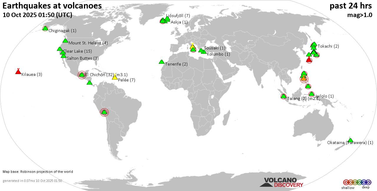
World map showing volcanoes with shallow (less than 50 km) earthquakes within 20 km radius during the past 24 hours on 10 Oct 2025 Number in brackets indicate nr of quakes.
Quakes detected near: Abu (4 quakes between mag 0.3-1.7), Akuseki-jima (1 quake mag 2.0), Askja (1 quake mag 1.2), Cagua (1 quake mag 2.6), Calatrava (1 quake mag 3.0), Camiguin de Babuyanes (1 quake mag 2.8)
Campi Flegrei (Phlegrean Fields) (24 quakes between mag 0.1-1.3), Clear Lake (18 quakes between mag 0.2-1.8), Coso (5 quakes between mag 0.8-2.8), Cuilapa-Barbarena (1 quake mag 2.6), El Chichón (64 quakes between mag 1.3-3.1), Eyafjallajökull (1 quake mag 1.1), Imbabura (1 quake mag 2.5), Iriomote-jima (1 quake mag 1.1), Jailolo (1 quake mag 2.3), Kilauea (3 quakes between mag 1.7-1.9), Kolumbo (1 quake mag 1.1), Komaga-take (4 quakes between mag 0.6-2.7), Kozushima (1 quake mag 2.0), Krísuvík (6 quakes between mag 0.3-2.0), Ljósufjöll (5 quakes between mag 0.7-1.8), Nasu (1 quake mag 1.1), Nigorigawa (4 quakes between mag 1.1-2.6), Nii-jima (1 quake mag 1.0), Norikura (3 quakes between mag 0.4-1.3), Okataina (Tarawera) (1 quake mag 1.5), Pelée (6 quakes between mag 0.6-1.0), Quimsachata (1 quake mag 3.0), Ragang (1 quake mag 2.3), Sakurajima (1 quake mag 1.0), Salton Buttes (3 quakes between mag 0.5-1.5), Santo Tomas (1 quake mag
Click this link to continue reading the article on the source website.
RSS feed source: USGS Earthquake Hazards Program
Date and TimeMag
DepthDistanceLocationDetailsMap Oct 10, 01:26 pm (GMT +8)
4.0
10 km53 km (33 mi) to the N Philippine Islands Region I FELT IT – 1 reportInfoOct 10, 01:18 pm (GMT +8)
4.0
10 km42 km (26 mi) to the NW Mindanao, Philippines I FELT IT – 1 reportInfoOct 10, 12:18 pm (GMT +8)
4.2
10 km10.7 km (6.6 mi) to the NW Philippine Islands Region I FELT IT – 2 reportsInfoOct 10, 11:53 am (Manila)
4.8
60 km61 km (38 mi) to the NW Philippine Sea, 28 km east of Manay, Philippines I FELT IT InfoOct 10, 11:32 am (GMT +8)
5.5
68 km41 km (25 mi) to the NW 35 km ESE of Manay, Philippines I FELT IT – 3 reportsInfoOct 10, 10:15 am (GMT +8)
5.2
48 km81 km (50 mi) to the N Philippine Islands Region I FELT IT – 1 reportInfoOct 10, 10:11 am (GMT +8)
5.6
63 km38 km (23 mi) to the NW 36 km ESE of San Ignacio, Philippines I FELT IT – 7 reportsInfoOct 10, 10:09 am (GMT +8)
5.2
10 km30 km (19 mi) to the W Philippine Sea, 67 km east of Mati, Philippines I FELT IT InfoOct 10, 09:51 am (GMT +8)
5.9
62 km39 km (24 mi) to the NW 40 km ESE of Manay, Philippines I FELT IT – 11 reportsInfoOct 10, 09:43 am (GMT +8)
7.4
58 km63 km (39 mi) to the NW 20 km E of Santiago, Philippines I FELT IT – 327 reportsInfoDec 2, 2023 10:37 pm (Manila)
7.6
40 km205 km (128 mi) to the N Philippine Sea, 36 km north of Bislig, Philippines 565 reportsInfoMay 5, 2022
Click this link to continue reading the article on the source website.
RSS feed source: USGS Earthquake Hazards Program
Date and TimeMag
DepthDistanceLocationDetailsMap Jan 22, 06:00 am (GMT +10)
5.3
10 km53 km (33 mi) to the W Bismarck Sea, 109 km southeast of Rambutyo Island, Papua New Guinea InfoJan 22, 04:52 am (GMT +10)
4.6
28 km24 km (15 mi) to the SE 215 km WSW of Kavieng, Papua New Guinea InfoDec 17, 2024 08:24 am (GMT +10)
4.6
10 km82 km (51 mi) to the E 158 km SW of Kavieng, Papua New Guinea InfoDec 8, 2024 05:46 am (GMT +10)
4.6
10 km97 km (61 mi) to the E158 km SW of Kavieng, Papua New Guinea InfoAug 22, 2024 01:54 am (GMT +10)
4.5
10 km34 km (21 mi) to the W 193 km SE of Lorengau, Papua New Guinea InfoJun 17, 2024 06:40 pm (GMT +10)
5.3
10 km43 km (26 mi) to the W 186 km SE of Lorengau, Papua New Guinea InfoMar 17, 2024 09:10 pm (GMT +10)
5.3
10 km34 km (21 mi) to the SW 210 km SE of Lorengau, Papua New Guinea InfoOct 9, 2023 04:07 am (GMT +10)
5.9
7 km54 km (33 mi) to the W Bismarck Sea, 117 km southeast of Rambutyo Island, Papua New Guinea 2 reportsInfoApr 10, 2023 11:09 am (GMT +10)
5.1
10 km23 km (15 mi) to the W 210 km SE of Lorengau, Papua New Guinea InfoApr 10, 2023 09:41 am (GMT +10)
5.8
10 km33 km (20 mi) to the SE Papua New Guinea: Bismarck Sea InfoAug 2, 2020 07:29 pm (GMT +10)
5.8
10 km20 km (13 mi) to the SW Bismarck Sea, 236 km west of Kavieng, New Ireland Province, Papua New Guinea InfoAug 2, 2020 05:22
Click this link to continue reading the article on the source website.