RSS feed source: Volcano Discovery.com--Global earthquake monitor

12 km (7 mi)

NE of epicenter

Guichixu

(pop: 401)

IV: Light

Santiago Laollaga, Oaxaca 15 km (9 mi)

E of epicenter

Santiago Laollaga

(pop: 2,550)

IV: Light

Oaxaca 18 km (11 mi)

SW of epicenter

Jalapa

(pop: 8,290)

IV: Light

Oaxaca 22 km (14 mi)

NW of epicenter

Santiago Lachiguiri

(pop: 1,650)

III: Weak

Oaxaca 26 km (16 mi)

E of epicenter

Ixtepec

(pop: 25,400)

III: Weak

Oaxaca 32 km (20 mi)

NE of epicenter

Santo Domingo Petapa

(pop: 5,430)

III: Weak

Oaxaca 33 km (20 mi)

SE of epicenter

San Blas Atempa

(pop: 12,000)

III: Weak

Oaxaca 33 km (21 mi)

S of epicenter

Santo Domingo Tehuantepec

(pop: 42,100)

III: Weak

Oaxaca 36 km (22 mi)

SW of epicenter

Magdalena Tequisistlan

(pop: 3,830)

III: Weak

Magdalena Tequisistlan, Oaxaca 39 km (24 mi)

SE of epicenter

Juchitan de Zaragoza

(pop: 74,800)

III: Weak

Heroica de Juchitan de Zaragoza, Oaxaca 40 km (25 mi)

N of epicenter

Zacatal

(pop: 1,140)

III: Weak

San Juan Guichicovi, Oaxaca 42 km (26 mi)

S of epicenter

Rincon Moreno

(pop: 1,020)

III: Weak

Santo Domingo Tehuantepec, Oaxaca 43 km (26 mi)

E of epicenter

La Ventosa

(pop: 4,880)

III: Weak

Heroica de Juchitan de Zaragoza, Oaxaca 44 km (27 mi)

SE of epicenter

Alvaro

Click this link to continue reading the article on the source website.

RSS feed source: Volcano Discovery.com--Global earthquake monitor

Mon, 21 Apr 2025, 01:50 | BY: EARTHQUAKEMONITOR

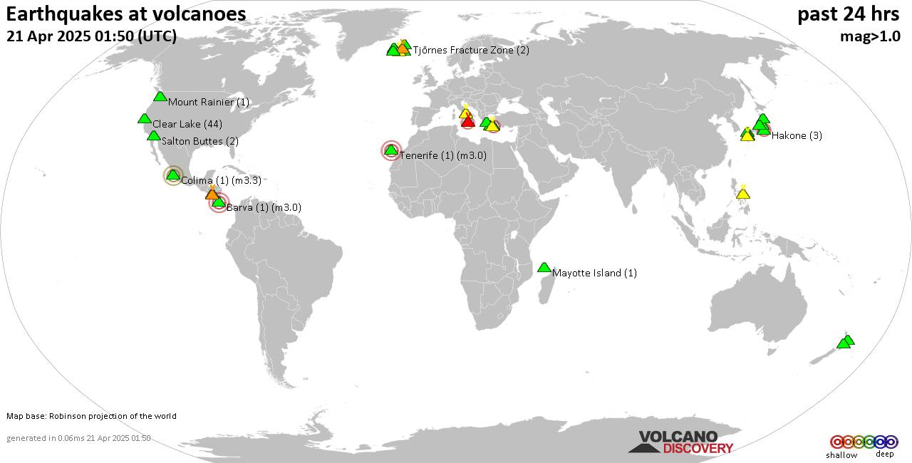
World map showing volcanoes with shallow (less than 50 km) earthquakes within 20 km radius during the past 24 hours on 21 Apr 2025 Number in brackets indicate nr of quakes.

Quakes detected near: Abu (29 quakes between mag 0.3-1.2), Aso (1 quake mag 1.8), Bardarbunga (9 quakes between mag 0.2-1.8), Barva (1 quake mag 3.0), Bulusan (1 quake mag 1.8), Campi Flegrei (Phlegrean Fields) (26 quakes between mag 0.1-1.8)
Clear Lake (44 quakes between mag 0.2-1.4), Colima (1 quake mag 3.3), Etna (1 quake mag 2.2), Hakone (3 quakes between mag 0.1-2.2), Hiuchi (4 quakes between mag 0.3-1.0), Hrómundartindur (4 quakes between mag 0.1-1.2), Katla (2 quakes between mag 0.2-1.2), Kolumbo (33 quakes between mag 0.0-2.2), Krísuvík (40 quakes between mag 0.0-1.1), Kurikoma (8 quakes between mag 0.3-2.0), Ljósufjöll (3 quakes between mag 0.3-1.4), Mayotte Island (1 quake mag 1.0), Milos (1 quake mag 2.1), Mount Rainier (1 quake mag 1.0), Myoko (1 quake mag 1.1), Okataina (Tarawera) (2 quakes between mag 1.6-1.8), Ruapehu (2 quakes between mag 1.2-1.3), Salton Buttes (2 quakes between mag 1.1-1.1), San Cristobal (1 quake mag 2.2), Santorini (2 quakes between mag 1.1-1.8), Sousaki (3 quakes between mag 0.7-1.8), Telica (1 quake mag 1.7), Tenerife (1 quake mag 3.0), Tjörnes Fracture Zone (2 quakes between mag 0.5-1.0), Tsurumi (2 quakes

Click this link to continue reading the article on the source website.
RSS feed source: Volcano Discovery.com--Global earthquake monitor

Date and TimeMag
DepthDistanceLocationDetailsMap Apr 15, 07:50 pm (Jayapura)

4.2

123 km93 km (58 mi) to the E Maluku Sea, 61 km southwest of Ternate, Ternate, North Maluku, IndonesiaI FELT IT InfoApr 14, 06:57 pm (GMT +9)

4.1

32 km97 km (61 mi) to the N Maluku Sea, 26 km west of Pulau Mayu Island, North Maluku, IndonesiaI FELT IT InfoApr 14, 10:33 am (GMT +9)

5.2

18 km22 km (14 mi) to the NW Maluku Sea, 93 km south of Pulau Mayu Island, North Maluku, IndonesiaI FELT IT1 reportInfoApr 9, 09:52 pm (GMT +9)

4.0

10 km71 km (44 mi) to the SW Maluku Sea, 130 km west of Pulau Latalata Island, North Maluku, Indonesia InfoMar 23, 07:56 am (GMT +9)

4.0

44 km61 km (38 mi) to the SE Northern Molucca Sea InfoMay 15, 2023 12:32 am (Jayapura)

5.9

109 km72 km (45 mi) to the E Maluku Sea, 63 km southwest of Ternate, Ternate, North Maluku, Indonesia 5 reportsInfoJan 18, 2023 03:06 pm (Jayapura)

7.1

64 km282 km (175 mi) to the N Maluku Sea, 116 km south of Pulau Kaburuang Island, Sulawesi Utara, Indonesia 13 reportsInfoJun 3, 2021 07:10 pm (Jayapura)

6.1

36 km3.3 km (2.1 mi) to the W Indonesia: Northern Molucca Sea 3 reportsInfoNov 15, 2019 01:17 am (Jayapura)

7.0

27 km133 km (83 mi) to the N Maluku Sea, North Maluku, 131 km east of Bitung, Sulawesi Utara, Indonesia 95 reportsInfoJul 14, 2019 06:10 pm (Jayapura)

7.1

10 km231 km (144 mi) to the SE 168 km southeast of Ternate, Ternate, North Maluku, Indonesia 13 reportsInfoJul 8, 2019 12:08 am (Jayapura)

6.8

29 km19 km

Click this link to continue reading the article on the source website.