RSS feed source: Volcano Discovery.com--Global earthquake monitor

Fri, 10 Oct 2025, 01:50 | BY: EARTHQUAKEMONITOR

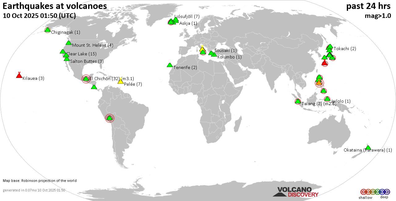
World map showing volcanoes with shallow (less than 50 km) earthquakes within 20 km radius during the past 24 hours on 10 Oct 2025 Number in brackets indicate nr of quakes.

Quakes detected near: Abu (2 quakes between mag 0.5-1.7), Askja (1 quake mag 1.2), Cagua (1 quake mag 2.6), Camiguin de Babuyanes (2 quakes between mag 2.8-2.8), Campi Flegrei (Phlegrean Fields) (21 quakes between mag 0.1-1.3), Chiginagak (1 quake mag 2.2)
Clear Lake (15 quakes between mag 0.3-1.8), Coso (2 quakes between mag 0.8-1.2), El Chichón (32 quakes between mag 1.8-3.1), Eyafjallajökull (1 quake mag 1.1), Haku-san (2 quakes between mag 0.6-1.5), Jailolo (1 quake mag 2.3), Kilauea (3 quakes between mag 1.7-1.9), Kolumbo (1 quake mag 1.1), Komaga-take (4 quakes between mag 0.6-2.7), Kozushima (1 quake mag 2.0), Krísuvík (4 quakes between mag 0.5-2.0), Lipari (1 quake mag 2.0), Ljósufjöll (7 quakes between mag 0.7-1.8), Megata (1 quake mag 1.9), Mount St. Helens (4 quakes between mag 0.3-1.0), Myoko (1 quake mag 1.1), Nigorigawa (4 quakes between mag 1.1-2.6), Nii-jima (1 quake mag 1.0), Norikura (3 quakes between mag 0.4-1.3), Okataina (Tarawera) (1 quake mag 1.5), Pelée (7 quakes between mag 0.5-1.0), Quimsachata (1 quake mag 3.0), Ragang (1 quake mag 2.3), Salton Buttes (3 quakes between mag 0.5-1.5), Santo Tomas (3 quakes between

Click this link to continue reading the article on the source website.
RSS feed source: Volcano Discovery.com--Global earthquake monitor

At 650 PM PDT, Doppler radar indicated thunderstorms producing heavy rain across the warned area. Between 0.5 and 1 inch of rain has fallen. Flash flooding is ongoing or expected to begin shortly. HAZARD…Life-threatening flash flooding. Thunderstorms producing flash flooding. SOURCE…Radar. IMPACT…Life-threatening flash flooding of low-water crossings, creeks, normally dry washes and roads. Some locations that will experience flash flooding include… Pahrump, Mercury and Indian Springs.

Click this link to continue reading the article on the source website.

RSS feed source: Volcano Discovery.com--Global earthquake monitor

Support Us – Help Us Enhance Our Services! We’re passionate about delivering the latest volcano and earthquake data from around the globe — just for you. However, maintaining our website and free apps requires significant time, effort, and resources.
Your support helps us expand our hardware and software capabilities and empowers our dedicated editorial team. Our mission is to provide uninterrupted, real-time updates whenever an earthquake strikes or a volcano erupts — and your donations make this possible. Every contribution, big or small, is deeply appreciated. If you find our information valuable and want to help us add new features, create compelling content, and improve our technology, please consider making a donation: Donate with Card or Apple/Google Pay: Donate with PayPal: Planned Features: Improved multilingual support Tsunami alerts Faster responsiveness Thanks to your past donations, we have recently added: Design upgrades Detailed earthquake statistics Additional seismic data sources Download the Volcanoes & Earthquakes app to stay among the first to receive the fastest seismic and volcano alerts online:
Android | iOS

Thank you for being part of our mission!

Click this link to continue reading the article on the source website.

RSS feed source: Volcano Discovery.com--Global earthquake monitor

Date and TimeMag
DepthDistanceLocationDetailsMap Oct 10, 02:45 am (Manila)

3.0

10 km513 km (319 mi) to the NW 13 km southwest of Bogo, Province of Cebu, Central Visayas, PhilippinesI FELT IT

Info

Oct 9, 11:34 pm (Manila)

3.2

5 km530 km (330 mi) to the NW Philippine Sea, 29 km south of Bantayan Island, PhilippinesI FELT IT

Info

Oct 9, 09:16 pm (Manila)

4.0

10 km518 km (322 mi) to the NW Philippine Sea, 8.2 km northeast of Bogo, PhilippinesI FELT IT2 reportsInfoOct 9, 06:30 pm (Manila)

3.1

5 km529 km (329 mi) to the NW Philippine Sea, 23 km east of Bantayan Island, PhilippinesI FELT IT

Info

Oct 9, 09:21 am (Manila)

3.2

4 km518 km (322 mi) to the NW Negros- Cebu Reg, Philippines  I FELT IT1 report

Info

Oct 3, 05:39 am (Manila)

5.3

10 km491 km (305 mi) to the NW 13 km WNW of Bantiqui, Philippines 37 reportsInfoSep 30, 10:12 pm (Manila)

5.2

10 km527 km (328 mi) to the NW Philippine Sea, 18 km northeast of Bogo, Philippines 54 reportsInfoSep 30, 09:59 pm (Manila)

6.9

10 km518 km (322 mi) to the NW Philippine Sea, Central Visayas, 54 km west of Ormoc, Philippines 922 reportsInfoAug 10, 2017 08:43 am (Manila)

5.3

519 km380 km (236 mi) to the NW Mindanao, Philippines InfoOct 21, 2013 09:12 am (Manila)

5.2

7 km423 km (263 mi) to the NW 056 km N 35° E of Tagbilaran City InfoOct 21, 2013 07:03 am (Manila)

5.3

23 km410 km (255 mi) to the NW 6 km ENE of Balilihan, Philippines 4 reportsInfoOct 20, 2013 04:05 pm (Manila)

5.3

10 km436 km (271 mi) to the NW 10 km WSW

Click this link to continue reading the article on the source website.