RSS feed source: USGS Earthquake Hazards Program
Time2025-08-23 07:58:32 UTC2025-08-23 07:58:32 UTC at epicenterLocation51.727°N 160.019°EDepth27.28 km (16.95 mi)
Click this link to continue reading the article on the source website.
RSS feed source: USGS Earthquake Hazards Program
Time2025-08-23 07:58:32 UTC2025-08-23 07:58:32 UTC at epicenterLocation51.727°N 160.019°EDepth27.28 km (16.95 mi)
Click this link to continue reading the article on the source website.
RSS feed source: USGS Earthquake Hazards Program
Date and TimeMag
DepthDistanceLocationDetailsMap Aug 22, 02:17 am (Jayapura)
4.2
202 km30 km (19 mi) to the E Banda Sea, 71 km north of Pulau Dai Island, Maluku, Indonesia I FELT IT InfoAug 20, 06:12 pm (GMT +9)
4.8
154 km74 km (46 mi) to the E Banda Sea I FELT IT – 1 reportInfoAug 18, 08:11 pm (GMT +9)
4.7
166 km84 km (52 mi) to the NE Banda Sea I FELT IT InfoAug 18, 03:43 pm (Jayapura)
4.1
103 km98 km (61 mi) to the NE Banda Sea I FELT IT InfoAug 12, 11:12 am (Jayapura)
4.3
150 km22 km (14 mi) to the S 294 km ENE of Lospalos, Timor Leste InfoNov 8, 2023 01:53 pm (GMT +9)
7.1
6 km63 km (39 mi) to the NE Banda Sea, 166 km north of Pulau Wetan Island, Maluku, Indonesia InfoNov 8, 2023 01:52 pm (GMT +9)
6.7
10 km74 km (46 mi) to the NE Banda Sea 7 reportsInfoSep 22, 2023 11:59 pm (Jayapura)
6.6
214 km68 km (42 mi) to the E Indonesia: Di Laut 184 Km Barat Laut Tanimbar 215 reportsInfoMay 25, 2023 12:49 am (Jayapura)
6.2
158 km27 km (17 mi) to the E Banda Sea 739 reportsInfoJan 10, 2023 02:47 am (Jayapura)
7.9
131 km105 km (65 mi) to the E Banda Sea, 101 km northeast of Pulau Wetan Island, Maluku, Indonesia 880 reportsInfoDec 30, 2021 03:25 am (Jayapura)
7.3
165 km201 km (125 mi) to the W Banda Sea, 19 km east of Pulau Romang Island, Maluku, Indonesia 1221 reportsInfoMay 6, 2020 10:53 pm (GMT +9)
6.7
113 km60 km (37 mi) to the E Banda Sea, 65 km south of Pulau Kekeh Besar Island, Maluku,
Click this link to continue reading the article on the source website.
RSS feed source: USGS Earthquake Hazards Program
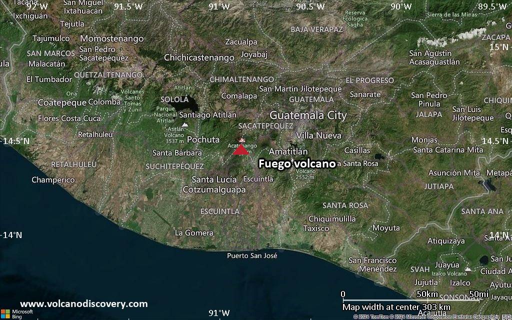
<!–div style="font-size:14px;text-align:center;border:3px solid blue;border-radius:5px;padding:3px;margin:5px;background:#eee"><a href="https://www.volcanoesandearthquakes.com/app/volcano-report.php?volcanoId=26" style="text-decoration:none" target="_blank" rel="noopener noreferrer nofollow" title="Share a volcano (activity) report, submit a photo or other interesting news!” onclick=”window.open(this.href,’Volcano Report’,’status=0,toolbar=0,location=0,directories=0,menubar=0,resizable=1,scrollbars=1,height=500,width=450′);return false”>Send Volcano Report</div–> Stratovolcano 3,763 m / 12,346 ft
Guatemala, 14.47°N / -90.88°W
Current status: erupting (4 out of 5) Fuego volcano eruptions:
1581, 1585, 1586, 1587, 1614, 1617, 1620, 1623, 1629, 1679(?), 1685, 1686, 1689(?), 1699, 1702, 1705, 1706, 1709(?), 1710,1717,1730, 1732, 1737, 1751(?), 1765(?), 1773(?), 1799, 1826, 1829, 1850(?), 1852(?), 1855, 1856, 1857, 1860, 1861(?), 1867(?), 1880, 1896, 1932, 1944, 1949, 1953, 1955, 1957, 1962, 1963, 1966, 1967, 1971, 1973, 1974, 1975, 1977, 1987, 1999, 2002 – ongoing
Typical eruption style
Dominantly explosive, construction of lava domes and extrusion of viscous lava flows. In near constant activity, at least during the past centuries.
Click this link to continue reading the article on the source website.
RSS feed source: USGS Earthquake Hazards Program
Background:
Volcán Popocatépetl, whose name is the Aztec word for smoking mountain, towers to 5426 m 70 km SE of Mexico City to form North America’s 2nd-highest volcano. The glacier-clad stratovolcano contains a steep-walled, 250-450 m deep crater. The generally symmetrical volcano is modified by the sharp-peaked Ventorrillo on the NW, a remnant of an earlier volcano.
At least three previous major cones were destroyed by gravitational failure during the Pleistocene, producing massive debris-avalanche deposits covering broad areas south of the volcano. The modern volcano was constructed to the south of the late-Pleistocene to Holocene El Fraile cone. Three major plinian eruptions, the most recent of which took place about 800 AD, have occurred from Popocatépetl since the mid Holocene, accompanied by pyroclastic flows and voluminous lahars that swept basins below the volcano. Frequent historical eruptions, first recorded in Aztec codices, have occurred since precolumbian
Click this link to continue reading the article on the source website.