RSS feed source: US National Weather Service

At 205 PM MDT, Doppler radar indicated thunderstorms producing heavy rain across the warned area. Between 1 and 1.5 inches of rain have fallen. Additional rainfall amounts up to 0.25 inches are possible in the warned area. Flash flooding is ongoing or expected to begin shortly. HAZARD…Flash flooding caused by thunderstorms. SOURCE…Radar. IMPACT…Flash flooding of small creeks and streams, urban areas, highways, streets and underpasses as well as other poor drainage and low-lying areas. Some locations that will experience flash flooding include… Redrock and Gila Middle Box.

Click this link to continue reading the article on the source website.

RSS feed source: US National Weather Service

Date and TimeMag
DepthDistanceLocationDetailsMap Aug 31, 12:10 pm (Salta)

4.4

182 km86 km (53 mi) to the S Departamento de Los Andes, 164 km west of Salta, Departamento Capital, Salta Province, ArgentinaI FELT IT InfoAug 31, 09:30 am (GMT -4)

3.5

292 km60 km (37 mi) to the SW Provincia de El Loa, 284 km east of Antofagasta, Provincia de Antofagasta, Region de Antofagasta, ChileI FELT IT

Info

Aug 30, 09:54 pm (GMT -3)

3.4

246 km46 km (29 mi) to the NE Departamento de Susques, 205 km northwest of San Salvador de Jujuy, Departamento de Doctor Manuel Belgrano, Jujuy Province, ArgentinaI FELT IT

Info

Aug 30, 03:13 pm (GMT -4)

3.0

213 km55 km (34 mi) to the SW Provincia de El Loa, 298 km east of Antofagasta, Provincia de Antofagasta, Region de Antofagasta, ChileI FELT IT

Info

Aug 29, 08:39 pm (GMT -3)

3.6

229 km87 km (54 mi) to the NE Departamento de Susques, 172 km northwest of San Salvador de Jujuy, Departamento de Doctor Manuel Belgrano, Jujuy Province, ArgentinaI FELT IT

Info

Aug 26, 11:26 am (Salta)

4.3

163 km59 km (37 mi) to the S Departamento de Los Andes, 190 km northwest of Salta, Departamento Capital, Salta Province, ArgentinaI FELT IT InfoAug 22, 03:10 am (Jujuy)

4.5

190 km84 km (52 mi) to the SE Departamento de Susques, Jujuy Province, 35 km northwest of San Antonio de los Cobres, Departamento de Los Andes, Salta Province, Argentina InfoAug 16, 07:47 am (Santiago)

3.9

279 km48 km (30 mi) to the N 177 km southeast of Calama, Provincia

Click this link to continue reading the article on the source website.

RSS feed source: US National Weather Service

* WHAT…Flooding caused by excessive rainfall is expected. * WHERE…A portion of southwest New Mexico, including the following county, Luna. * WHEN…Until 400 PM MDT. * IMPACTS…Minor flooding in low-lying and poor drainage areas. * ADDITIONAL DETAILS… – At 201 PM MDT, Doppler radar indicated heavy rain due to thunderstorms. Minor flooding is ongoing or expected to begin shortly in the advisory area. Up to 2.5 inches of rain have fallen. – Additional rainfall of up to 1 inch is expected over the area. This additional rain will result in minor flooding. – Some locations that may experience flooding include… mainly rural areas of Southeastern Luna County – http://www.weather.gov/safety/flood

Click this link to continue reading the article on the source website.
RSS feed source: US National Weather Service

Sun, 31 Aug 2025, 19:50 | BY: EARTHQUAKEMONITOR

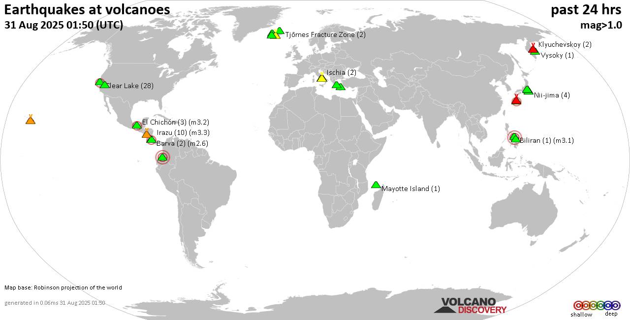
World map showing volcanoes with shallow (less than 50 km) earthquakes within 20 km radius during the past 24 hours on 31 Aug 2025 Number in brackets indicate nr of quakes.

Quakes detected near: Akuseki-jima (3 quakes between mag 2.4-2.8), Askja (1 quake mag 1.5), Bardarbunga (3 quakes between mag 0.1-1.4), Campi Flegrei (Phlegrean Fields) (34 quakes between mag 0.1-3.3), Clear Lake (23 quakes between mag 0.2-1.8), Coso (5 quakes between mag 0.2-1.8)
El Chichón (5 quakes between mag 2.3-3.0), Eldey (51 quakes between mag 0.2-3.3), Galeras (2 quakes between mag 1.1-3.6), Hofsjökull (8 quakes between mag 0.5-2.8), Hrómundartindur (2 quakes between mag 0.5-1.6), Ischia (2 quakes between mag 1.3-1.4), Katla (16 quakes between mag 0.3-2.1), Kilauea (1 quake mag 1.8), Kolumbo (2 quakes between mag 1.7-2.0), Krafla (2 quakes between mag 0.2-1.0), Krísuvík (24 quakes between mag 0.0-1.7), Kverkfjöll (1 quake mag 1.2), Ljósufjöll (3 quakes between mag 0.8-1.5), Mayotte Island (1 quake mag 1.4), Michoacán-Guanajuato (4 quakes between mag 1.7-2.5), Miyake-shima (1 quake mag 1.7), Mt Fuji (1 quake mag 1.1), Nemrut Dagi (2 quakes between mag 1.1-1.4), Nii-jima (5 quakes between mag 1.0-1.5), Pico de Orizaba (1 quake mag 2.8), Santorini (2 quakes between mag 0.8-1.1), Sousaki (1 quake mag 2.4), Suwanose-jima (2 quakes between mag 2.1-2.3), Svartsengi (4 quakes between mag 0.1-2.5),

Click this link to continue reading the article on the source website.