RSS feed source: Volcano Discovery.com--Global earthquake monitor

Sun, 5 Oct 2025, 01:50 | BY: EARTHQUAKEMONITOR

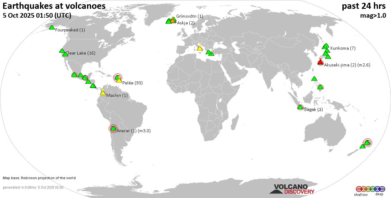
World map showing volcanoes with shallow (less than 50 km) earthquakes within 20 km radius during the past 24 hours on 5 Oct 2025 Number in brackets indicate nr of quakes.

Quakes detected near: Akuseki-jima (2 quakes between mag 2.4-2.6), Apaneca Range (2 quakes between mag 1.6-1.8), Aracar (1 quake mag 3.0), Askja (2 quakes between mag 0.2-1.2), Bardarbunga (1 quake mag 1.3), Campi Flegrei (Phlegrean Fields) (30 quakes between mag 0.1-3.3)
Clear Lake (16 quakes between mag 0.2-1.5), Colima (1 quake mag 2.7), Coso (3 quakes between mag 0.7-1.0), El Chichón (3 quakes between mag 2.3-2.6), Fourpeaked (1 quake mag 1.7), Gagak (1 quake mag 2.3), Grímsvötn (1 quake mag 1.9), Kolumbo (3 quakes between mag 1.1-1.6), Kozushima (1 quake mag 1.7), Krísuvík (23 quakes between mag 0.1-3.0), Kurikoma (7 quakes between mag 0.2-1.3), Liamuiga (1 quake mag 3.0), Ljósufjöll (2 quakes between mag 0.8-1.7), Machin (1 quake mag 1.2), Nigorigawa (1 quake mag 1.0), Niigata-Yake-yama (5 quakes between mag 0.1-2.9), Nipesotsu-Maruyama (1 quake mag 1.6), Paco (1 quake mag 2.3), Pelée (93 quakes between mag 0.1-1.3), Platanar (2 quakes between mag 1.5-1.6), Prestahnukur (1 quake mag 1.3), Rumble III (2 quakes between mag 3.9-4.0), Rumble IV (1 quake mag 3.3), Santo Tomas (2 quakes between mag 1.7-3.0), Serdán-Oriental (1 quake mag 2.3), Sousaki (1

Click this link to continue reading the article on the source website.

RSS feed source: Volcano Discovery.com--Global earthquake monitor

Date and TimeMag
DepthDistanceLocationDetailsMap Jul 16, 09:03 am (Manila)

4.5

38 km112 km (70 mi) to the E 31 km northeast of Laoag, Province of Ilocos Norte, Ilocos, Philippines 2 reportsInfoJul 15, 10:38 am (Manila)

5.5

49 km118 km (73 mi) to the SE Province of Ilocos Norte, 69 km northeast of Vigan, Philippines 24 reportsInfoJul 15, 07:22 am (GMT +8)

4.8

4 km100 km (62 mi) to the S Philippine Islands Region InfoJul 11, 08:52 pm (Manila)

4.4

10 km107 km (66 mi) to the E 20 km north of Laoag, Province of Ilocos Norte, Ilocos, Philippines 3 reportsInfoMay 23, 01:14 am (GMT +8)

4.0

10 km82 km (51 mi) to the E Luzon, Philippines InfoDec 22, 2024 03:37 pm (GMT +8)

4.9

10 km102 km (63 mi) to the S 88 km W of Puro Pinget, Philippines InfoDec 21, 2024 07:53 am (GMT +8)

4.9

10 km114 km (71 mi) to the S South China Sea, 75 km west of Vigan, Philippines InfoDec 19, 2024 02:55 pm (GMT +8)

5.1

10 km111 km (69 mi) to the S 78 km W of Cabittaogan, Philippines InfoDec 19, 2024 02:42 pm (GMT +8)

5.1

10 km115 km (71 mi) to the S 88 km W of Cabittaogan, Philippines InfoJul 27, 2022 08:43 am (Manila)

7.0

34 km173 km (107 mi) to the SE 11 km NE of Bantay, Philippines 2352 reportsInfoMar 3, 2019 03:46 am (GMT +8)

5.5

10 km75 km (47 mi) to the E Luzon, Philippines 10 reportsInfoMar 12, 2016 12:00 pm (GMT +8)

5.3

10 km79 km (49 mi) to the SE Luzon, Philippines InfoApr 22, 2014 04:45 am (GMT +8)

5.4

9.5 km142 km (88 mi) to the S South China Sea, 51 km

Click this link to continue reading the article on the source website.

RSS feed source: Volcano Discovery.com--Global earthquake monitor

* WHAT…Life-threatening rip currents. * WHERE…Beaches of Vieques and Saint Croix. * WHEN…Through Tuesday afternoon. * IMPACTS…Rip currents can sweep even the best swimmers away from shore into deeper water, where it becomes difficult to return to safety.

Click this link to continue reading the article on the source website.

RSS feed source: Volcano Discovery.com--Global earthquake monitor

* WHAT…For the High Surf Advisory, large breaking waves up to 12 feet. For the High Rip Current Risk, life-threatening rip currents. * WHERE…For the High Surf Advisory, the most vulnerable areas for high surf and beach erosion include Barrio Espinal in Aguada. For the High Rip Current Risk, beaches of Aguada and Rincon in Puerto Rico, Culebra, and the northern US Virgin Islands. * WHEN…For the High Surf Advisory remains until 6 AM AST Monday. For the High Rip Current Risk remains through Tuesday afternoon * IMPACTS…For the High Surf Advisory, High waves that can wash over jetties and sweep people and pets onto jagged rocks. Rough surf may also

Click this link to continue reading the article on the source website.