RSS feed source: US National Weather Service

* WHAT…Visibility one quarter to one half mile in dense fog. * WHERE…Brown, Jackson, Jefferson, Marshall, and Nemaha Counties. * WHEN…Until noon CST today. * IMPACTS…Low visibility could make driving conditions hazardous.

Click this link to continue reading the article on the source website.

RSS feed source: US National Weather Service

* WHAT…Flooding caused by excessive rainfall is expected. * WHERE…A portion of south central Texas, including the following county, Edwards. * WHEN…Until 100 PM CST. * IMPACTS…Minor flooding in low-lying and poor drainage areas. * ADDITIONAL DETAILS… – At 958 AM CST, Doppler radar indicated heavy rain due to thunderstorms. Minor flooding is ongoing or expected to begin shortly in the advisory area. Up to 1 inch of rain has fallen. – Some locations that will experience flooding include… Rocksprings, Carta Valley and Devil’s Sinkhole State Natural Area. – http://www.weather.gov/safety/flood

Click this link to continue reading the article on the source website.

RSS feed source: US National Weather Service

Date and TimeMag
DepthDistanceLocationDetailsMap Nov 16, 09:03 am (GMT +11)

4.4

10 km94 km (58 mi) to the N Coral Sea, 277 km east of Kirakira, Makira-Ulawa Province, Solomon IslandsI FELT IT InfoSep 13, 04:29 am (GMT +11)

5.1

62 km114 km (71 mi) to the NE Coral Sea, 103 km west of New Jersey Island, Solomon Islands InfoSep 3, 11:15 am (GMT +11)

5.0

10 km111 km (69 mi) to the E Coral Sea, 79 km south of Lata, Temotu Province, Solomon Islands InfoJun 29, 10:35 am (GMT +11)

4.5

10 km114 km (71 mi) to the NE Coral Sea, 53 km southwest of Lata, Temotu Province, Solomon Islands InfoJun 29, 06:05 am (GMT +11)

4.6

10 km104 km (65 mi) to the SE Coral Sea, 140 km southwest of Utupua Island, Solomon Islands InfoApr 8, 12:29 am (GMT +11)

5.1

10 km47 km (29 mi) to the E Coral Sea, 149 km southwest of New Jersey Island, Solomon Islands InfoMar 20, 01:48 am (GMT +11)

4.9

10 km108 km (67 mi) to the N Coral Sea, 143 km west of New Jersey Island, Solomon Islands InfoJan 17, 03:24 pm (GMT +11)

4.9

10 km100 km (62 mi) to the N Coral Sea, 184 km west of New Jersey Island, Solomon Islands InfoSep 18, 2022 08:41 pm (GMT +11)

5.7

10 km97 km (60 mi) to the N Coral Sea, 262 km east of Kirakira, Makira-Ulawa Province, Solomon Islands InfoFeb 1, 2018 06:15 am (GMT +11)

5.5

8 km94 km (58 mi) to the NCoral Sea, 189 km west of New Jersey Island, Solomon Islands InfoJul 4, 2016 08:25 pm (GMT

Click this link to continue reading the article on the source website.

RSS feed source: US National Weather Service

Thursday, Nov 20, 2025 15:50 | 31 mins ago | By: EarthquakeMonitor

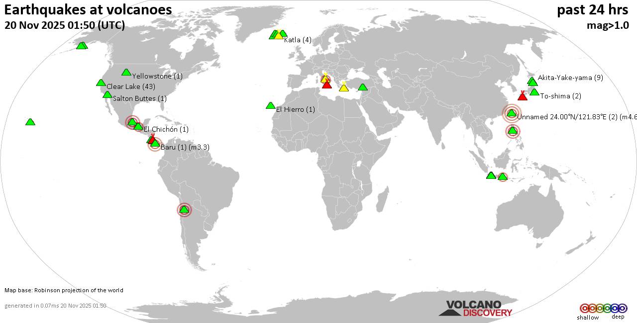
World map showing volcanoes with shallow (less than 50 km) earthquakes within 20 km radius during the past 24 hours on 20 Nov 2025 Number in brackets indicate nr of quakes.

Quakes detected near: Akita-Yake-yama (8 quakes between mag 0.2-1.1), Arayat (1 quake mag 3.0), Askja (2 quakes between mag 1.1-1.7), Baluran (1 quake mag 2.7), Baru (1 quake mag 3.3), Campi Flegrei (Phlegrean Fields) (31 quakes between mag 0.1-2.5)
Clear Lake (40 quakes between mag 0.2-2.1), Cofre de Perote (1 quake mag 2.8), Coso (2 quakes between mag 0.9-1.7), Cuernos de Negros (1 quake mag 3.0), El Chichón (27 quakes between mag 1.6-3.1), El Hierro (1 quake mag 1.2), Eldey (4 quakes between mag 1.4-1.9), Etna (1 quake mag 1.0), Grímsnes (1 quake mag 1.0), Hrómundartindur (9 quakes between mag 0.1-1.3), Irazu (1 quake mag 2.1), Katla (6 quakes between mag 0.5-1.4), Kawah Kamojang (1 quake mag 1.8), Kilauea (1 quake mag 1.9), Kirishima (6 quakes between mag 0.2-3.0), Koruhüyüğü (1 quake mag 1.8), Krísuvík (8 quakes between mag 0.1-1.5), Kukak (1 quake mag 1.9), Kula (1 quake mag 1.1), Kurikoma (5 quakes between mag 0.4-1.3), Lamonai (Dawson Strait Group) (1 quake mag 4.6), Ljósufjöll (8 quakes between mag 0.1-1.6), Loki-Fögrufjöll volcano (4 quakes between mag 0.3-1.0), Maroa (2 quakes

Click this link to continue reading the article on the source website.