RSS feed source: Volcano Discovery.com--Global earthquake monitor

Sat, 14 Jun 2025, 01:50 | BY: EARTHQUAKEMONITOR

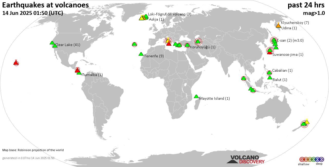
World map showing volcanoes with shallow (less than 50 km) earthquakes within 20 km radius during the past 24 hours on 14 Jun 2025 Number in brackets indicate nr of quakes.

Quakes detected near: Akita-Yake-yama (2 quakes between mag 0.6-1.1), Akyarlar (1 quake mag 2.6), Askja (1 quake mag 1.1), Azuma (1 quake mag 1.5), Balut (1 quake mag 1.7), Brennisteinsfjöll (6 quakes between mag 0.1-1.0)
Cabalian (1 quake mag 2.2), Campi Flegrei (Phlegrean Fields) (7 quakes between mag 0.1-3.0), Clear Lake (41 quakes between mag 0.2-1.8), Coso (9 quakes between mag 0.1-1.8), E-san (2 quakes between mag 3.0-3.0), Eldey (2 quakes between mag 1.2-1.5), Etna (2 quakes between mag 0.9-1.2), Furnas (2 quakes between mag 2.0-2.6), Gede-Pangrango (1 quake mag 2.6), Geureudong (1 quake mag 2.0), Hekla (1 quake mag 1.7), Hulubelu (2 quakes between mag 2.4-2.4), Kilauea (3 quakes between mag 1.7-2.9), Kirishima (7 quakes between mag 0.2-3.0), Klyuchevskoy (7 quakes between mag 0.8-1.4), Kolumbo (7 quakes between mag 1.5-2.1), Koruhüyüğü (1 quake mag 2.3), Ljósufjöll (7 quakes between mag 0.1-1.5), Lokbatan (1 quake mag 3.0), Loki-Fögrufjöll volcano (3 quakes between mag 0.6-2.2), Masaya (2 quakes between mag 2.0-2.1), Mayotte Island (1 quake mag 1.2), Prestahnukur (1 quake mag 1.3), Ruapehu (2 quakes between mag 1.2-3.0), Sousaki (1 quake mag 1.1), Suwanose-jima (1 quake

Click this link to continue reading the article on the source website.
RSS feed source: Volcano Discovery.com--Global earthquake monitor

Date and TimeMag
DepthDistanceLocationDetailsMap Jun 7, 07:09 pm (Taipei)

4.0

17 km4.5 km (2.8 mi) to the SE 33 km northeast of Yongkang, TaiwanI FELT IT InfoMay 14, 10:48 am (Taipei)

4.0

10 km10.4 km (6.5 mi) to the N 20 km south of Chiayi City, Taiwan 1 reportInfoMay 13, 03:37 am (Taipei)

4.0

11 km93 km (58 mi) to the E Philippine Sea, 33 km northeast of Taitung, Taiwan 1 reportInfoMay 10, 05:27 am (Taipei)

4.3

20 km68 km (42 mi) to the N 13 km south of Nantou, Taiwan InfoApr 25, 06:10 am (Taipei)

4.1

7.6 km2.2 km (1.4 mi) to the N 27 km south of Chiayi City, Taiwan InfoJan 21, 12:17 am (Taipei)

6.0

16 km8.2 km (5.1 mi) to the SE 39 km northeast of Tainan, Taiwan 79 reportsInfoApr 3, 2024 07:58 am (Taipei)

7.4

40 km132 km (82 mi) to the NE Philippine Sea, 16 km south of Hualien City, Taiwan 232 reportsInfoSep 18, 2022 05:39 pm (Taipei)

5.9

10 km82 km (51 mi) to the E 80 km SE of Lugu, Taiwan 1 reportInfoSep 18, 2022 02:44 pm (Taipei)

6.9

10 km88 km (55 mi) to the E 47 km northeast of Taitung, Taiwan 42 reportsInfoSep 17, 2022 09:41 pm (Taipei)

6.5

10 km95 km (59 mi) to the E 96 km SE of Lugu, Taiwan 65 reportsInfoFeb 6, 2016 03:57 am (Taipei)

6.2

32 km50 km (31 mi) to the SE Taiwan 59 reportsInfoJun 2, 2013 01:43 pm (Taipei)

6.2

17 km92 km (57 mi) to the NE 26 km SE of Puli, Taiwan 24 reportsInfoMar 4, 2010 08:18 am (Taipei)

6.3

21 km46 km (28 mi) to the SE Kaohsiung, 40 km northwest of Taitung, Taiwan InfoDec 26,

Click this link to continue reading the article on the source website.

RSS feed source: Volcano Discovery.com--Global earthquake monitor

<!–div style="font-size:14px;text-align:center;border:3px solid blue;border-radius:5px;padding:3px;margin:5px;background:#eee"><a href="https://www.volcanoesandearthquakes.com/app/volcano-report.php?volcanoId=168" style="text-decoration:none" target="_blank" rel="noopener noreferrer nofollow" title="Share a volcano (activity) report, submit a photo or other interesting news!” onclick=”window.open(this.href,’Volcano Report’,’status=0,toolbar=0,location=0,directories=0,menubar=0,resizable=1,scrollbars=1,height=500,width=450′);return false”>Send Volcano Report</div–> Stratovolcano 3332 m (10,932 ft)
East Java (Indonesia), -8.13°S / 114.04°E
Current status: minor activity or eruption warning (3 out of 5) Raung volcano eruptions:
1586 (?), 1593 (large sub-plinian eruption), 1597, 1638, 1730, 1804+-4y, 1812-14, 1815 +-1y, 1817, 1838, 1849, 1859, 1860, 1864, 1881, 1885, 1890, 1896, 1897, 1902, 1903, 1913, 1915, 1916, 1917, 1921, 1924, 1924, 1927-28, 1928, 1929, 1933, 1936, 1937, 1938-39, 1940, 1941, 1943, 1944-45, 1953, 1955, 1956, 1971, 1973, 1974, 1975, 1976, 1977, 1978, 1982, 1985, 1987-89, 1990, 1991, 1993, 1994, 1995, 1995 (?), 1997, 1999, Jul 2000, Jun-Aug 2002, Apr-Oct 2004 (?), Jul-Aug 2005 (?), Aug 2007 (?), 2012, 2014-15, 2020-ongoing
Typical eruption style
Explosive

Click this link to continue reading the article on the source website.

RSS feed source: Volcano Discovery.com--Global earthquake monitor

Date and TimeMag
DepthDistanceLocationDetailsMap May 27, 08:30 pm (GMT -4)

3.8

34 km4.9 km (3.1 mi) to the NW North Atlantic Ocean, 121 km northeast of Anegada Island, British Virgin Islands

Info

May 26, 10:55 pm (GMT -4)

4.5

10 km19 km (12 mi) to the S North Atlantic Ocean, 114 km northeast of Anegada Island, British Virgin Islands InfoMay 24, 12:12 am (GMT -4)

3.7

63 km99 km (62 mi) to the SW North Atlantic Ocean, 35 km north of Anegada Island, British Virgin Islands

Info

May 4, 07:41 pm (GMT -4)

3.6

25 km93 km (58 mi) to the SW 92 km NE of Cruz Bay, U.S. Virgin Islands

Info

May 4, 04:01 am (GMT -4)

3.4

13 km100 km (62 mi) to the SW 97 km NNE of Cruz Bay, U.S. Virgin Islands

Info

Mar 27, 02:57 am (Anguilla)

4.2

50 km98 km (61 mi) to the S 52 km NNW of Sandy Ground Village, Anguilla 31 reportsInfoFeb 1, 02:16 pm (GMT -4)

4.0

41 km56 km (35 mi) to the W 142 km NE of Cruz Bay, U.S. Virgin Islands InfoJan 26, 06:49 am (GMT -4)

4.0

29 km75 km (47 mi) to the SW 114 km NE of Cruz Bay, U.S. Virgin Islands InfoJan 26, 02:02 am (GMT -4)

3.9

29 km73 km (45 mi) to the SW 118 km NE of Cruz Bay, U.S. Virgin Islands

Info

Aug 31, 2019 04:45 am (GMT -4)

4.9

7 km58 km (36 mi) to the SW North Atlantic Ocean, 107 km northeast of Road Town, British Virgin Islands InfoJan 10, 2013 12:33 pm (GMT -4)

5.0

5.9 km100 km (62 mi) to the W North Atlantic Ocean, 124 km north

Click this link to continue reading the article on the source website.