RSS feed source: Volcano Discovery.com--Global earthquake monitor

Sun, 5 Oct 2025, 21:50 | BY: EARTHQUAKEMONITOR

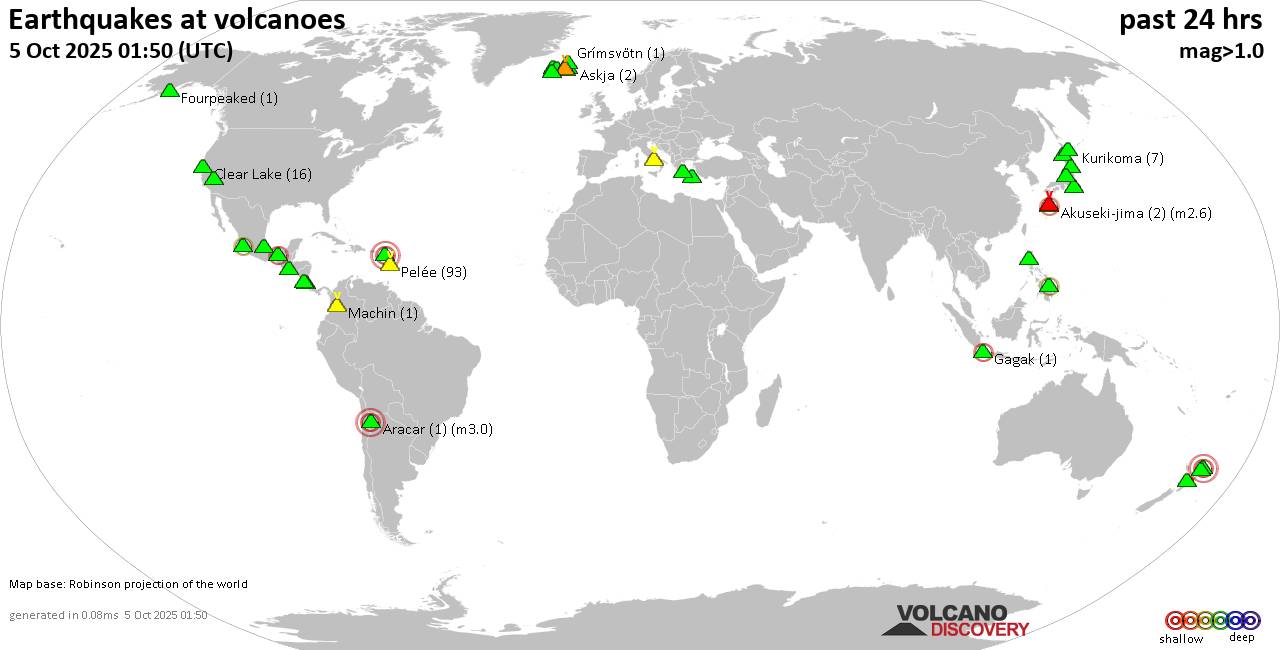
World map showing volcanoes with shallow (less than 50 km) earthquakes within 20 km radius during the past 24 hours on 5 Oct 2025 Number in brackets indicate nr of quakes.

Quakes detected near: Aguilera (1 quake mag 3.6), Akagi (2 quakes between mag 1.1-2.3), Akuseki-jima (4 quakes between mag 1.9-3.4), Apaneca Range (1 quake mag 1.9), Aracar (1 quake mag 3.0), Bardarbunga (2 quakes between mag 0.7-1.4)
Campi Flegrei (Phlegrean Fields) (23 quakes between mag 0.1-3.3), Cerro Singüil (1 quake mag 2.7), Clear Lake (19 quakes between mag 0.3-1.6), Conchagüita (1 quake mag 2.1), Coso (6 quakes between mag 0.6-1.6), El Chichón (14 quakes between mag 1.4-2.2), Eldey (2 quakes between mag 0.5-2.0), Etna (3 quakes between mag 1.3-2.0), Geureudong (1 quake mag 2.5), Gran Canaria (1 quake mag 3.0), Hrómundartindur (4 quakes between mag 0.6-1.3), Jan Mayen (1 quake mag 4.6), Kalatungan (1 quake mag 2.0), Katla (7 quakes between mag 0.7-2.1), Kilauea (1 quake mag 2.4), Kirishima (5 quakes between mag 0.2-1.0), Kolumbo (1 quake mag 1.8), Krísuvík (15 quakes between mag 0.0-1.1), Kuchinoshima (1 quake mag 1.6), Kurikoma (1 quake mag 1.0), Laacher See (1 quake mag 3.0), Lipari (1 quake mag 2.0), Ljósufjöll (5 quakes between mag 0.4-1.9), Methana (1 quake mag 1.5), Nevado del Huila (1 quake mag 1.8), Nevado

Click this link to continue reading the article on the source website.

RSS feed source: Volcano Discovery.com--Global earthquake monitor

* WHAT…Flooding caused by excessive rainfall continues. * WHERE…A portion of southwest Alabama, including the following county, Baldwin. * WHEN…Until 630 PM CDT. * IMPACTS…Minor flooding in low-lying and poor drainage areas. Water over roadways. * ADDITIONAL DETAILS… – At 448 PM CDT, emergency management reported heavy rain in the advisory area due to thunderstorms. Minor flooding is already occurring. Between 5 and 7 inches of rain have fallen. – Flooding impacts will continue, but no additional rainfall is expected. – Some locations that will experience flooding include… Foley, Orange Beach, Perdido Beach, Elberta, Miflin, Josephine and Caswell. – http://www.weather.gov/safety/flood

Click this link to continue reading the article on the source website.

RSS feed source: Volcano Discovery.com--Global earthquake monitor

* WHAT…For the High Surf Advisory, large breaking waves of 10-12 feet. For the HIGH RIP CURRENT RISK, life-threatening rip current. * WHERE… For the HIGH SURF ADVISORY, the most vulnerable areas for high surf and beach erosion include Pinones along Road 187, Parcelas Suarez, Villas del Mar, and Villa Christiana in Loiza; Fortuna in Luquillo; Pueblo and Tamarindo in Aguadilla; Bario Obrero, Pueblo and Jareaito in Arecibo; Las Boca in Barceloneta; Machuca in Manati; Puerto Nuevo in Vega Baja; Ocean Park in San Juan; and Barrio Espinal in Aguada. For the HIGH RIP CURRENT RISK For the coastal areas of western PR. * WHEN…For the High Surf Advisory remains until

Click this link to continue reading the article on the source website.

RSS feed source: Volcano Discovery.com--Global earthquake monitor

* WHAT…For the High Surf Advisory, large breaking waves of 10-12 feet. For the HIGH RIP CURRENT RISK, life-threatening rip current. * WHERE… For the HIGH SURF ADVISORY, the most vulnerable areas for high surf and beach erosion include Pinones along Road 187, Parcelas Suarez, Villas del Mar, and Villa Christiana in Loiza; Fortuna in Luquillo; Pueblo and Tamarindo in Aguadilla; Bario Obrero, Pueblo and Jareaito in Arecibo; Las Boca in Barceloneta; Machuca in Manati; Puerto Nuevo in Vega Baja; Ocean Park in San Juan; and Barrio Espinal in Aguada. For the HIGH RIP CURRENT RISK across St. Croix. * WHEN…For the High Rip Current Risk remains through tuesday afternoon. For

Click this link to continue reading the article on the source website.