RSS feed source: US National Weather Service

…The Flood Warning continues for the following rivers in Mississippi… Tombigbee River at Bigbee For the Tombigbee River…including Fulton, Bigbee, Amory, Aberdeen L & D…Minor flooding is forecast. * WHAT…Minor flooding is occurring and minor flooding is forecast. * WHERE…Tombigbee River at Bigbee. * WHEN…Until late Thursday evening. * IMPACTS…At 18.0 feet, Water is flowing over Hood Road. The flood plain between Town Creek and the Tombigbee River is flooded. Extensive agricultural flooding is occurring along Highway 6 near Bigbee. * ADDITIONAL DETAILS… – At 6:30 AM CDT Tuesday the stage was 15.3 feet. – Recent Activity…The maximum river stage in the 24 hours ending at 6:30 AM CDT Tuesday was

Click this link to continue reading the article on the source website.

RSS feed source: US National Weather Service

…The Flood Warning continues for the following rivers in Missouri…Arkansas…Tennessee… Mississippi River at Caruthersville For the Lower Mississippi River…including Caruthersville…Minor flooding is forecast. * WHAT…Minor flooding is occurring and minor flooding is forecast. * WHERE…Mississippi River at Caruthersville. * WHEN…Until Friday, April 25. * IMPACTS…At 40.5 feet, In Missouri, the boat fabrication factory north of Caruthersville is mostly underwater. Some of the floodwall at Caruthersville has a foot of water against it. Access road to the grain elevator northeast of Huffman, Arkansas is flooded. West end of Bradley Road in Lauderdale County, Tennessee is flooded. * ADDITIONAL DETAILS… – At 7:00 AM CDT Tuesday the stage was 35.3 feet. – Recent

Click this link to continue reading the article on the source website.
RSS feed source: US National Weather Service

…The Flood Warning continues for the following rivers in Arkansas…Tennessee… Mississippi River at Osceola For the Lower Mississippi River…including Osceola…Major flooding is forecast. * WHAT…Minor flooding is occurring and major flooding is forecast. * WHERE…Mississippi River at Osceola. * WHEN…Until Saturday, April 26. * IMPACTS…At 37.0 feet, In Tennessee, houses along the west part of Grammer Road are flooding and evacuation is cut off. The south end of Grainery Road is inundated. Homesteads along Highway 19 West just east of T. Rossinger Road are going underwater. Shoaf Landing Road is flooding. Farmstead on Island 37 floods. * ADDITIONAL DETAILS… – At 7:00 AM CDT Tuesday the stage was 30.5 feet. –

Click this link to continue reading the article on the source website.

RSS feed source: US National Weather Service

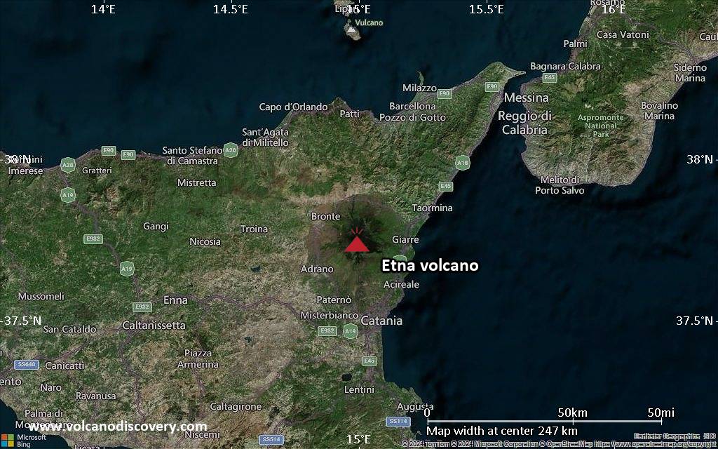
<!–div style="font-size:14px;text-align:center;border:3px solid blue;border-radius:5px;padding:3px;margin:5px;background:#eee"><a href="https://www.volcanoesandearthquakes.com/app/volcano-report.php?volcanoId=16" style="text-decoration:none" target="_blank" rel="noopener noreferrer nofollow" title="Share a volcano (activity) report, submit a photo or other interesting news!” onclick=”window.open(this.href,’Volcano Report’,’status=0,toolbar=0,location=0,directories=0,menubar=0,resizable=1,scrollbars=1,height=500,width=450′);return false”>Send Volcano Report</div–> Complex stratovolcano Currently 3,369 m / 11,053 ft (changing due to eruptive activity and collapse of its crater rims)
Sicily, Italy, 37.75°N / 14.99°E
Current status: erupting (4 out of 5) Etna volcano eruptions:
Near continuously active; some major historic eruptions include 122 BC (large Plinian outbursts that created the small caldera of the “Cratere del Piano”), 1669 AD (devastating flank eruption that destroyed 15 villages and part of Catania), 1787 (Subplinian eruption and one of the most spectacular summit eruptions on record – lava fountains reportedly up to 3000 m high).
Eruptions since 1950 (f: flank / s: summit activity): 1950 (s), 1950-51(f), 1955 (s), 1956 (s), 1956 (f), 1957 (s),1960 (s), 1961 (s), 1964 (f), 1964 (s), 1966

Click this link to continue reading the article on the source website.