RSS feed source: Volcano Discovery.com--Global earthquake monitor

Mon, 18 Aug 2025, 13:50 | BY: EARTHQUAKEMONITOR

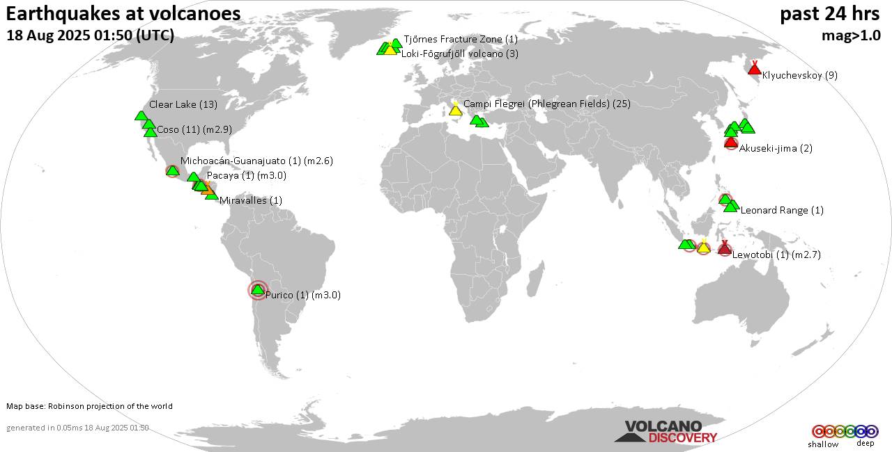
World map showing volcanoes with shallow (less than 50 km) earthquakes within 20 km radius during the past 24 hours on 18 Aug 2025 Number in brackets indicate nr of quakes.

Quakes detected near: Abu (38 quakes between mag 0.1-1.4), Agua (1 quake mag 2.9), Akuseki-jima (3 quakes between mag 1.8-2.3), Cabalian (1 quake mag 2.1), Cerro Singüil (1 quake mag 3.2), Ciremai (1 quake mag 2.6)
Clear Lake (12 quakes between mag 0.3-1.4), Coso (15 quakes between mag 0.1-2.9), Cuernos de Negros (1 quake mag 2.6), Daisen (1 quake mag 1.8), El Chichón (5 quakes between mag 1.9-2.6), Eldey (1 quake mag 1.2), Etna (1 quake mag 1.2), Grímsvötn (1 quake mag 1.0), Haruna (2 quakes between mag 0.2-1.4), Hulubelu (1 quake mag 1.3), Ijen (11 quakes between mag 2.7-4.0), Izu-Tobu (3 quakes between mag 0.6-1.6), Katla (8 quakes between mag 0.2-2.0), Kenger (1 quake mag 1.7), Kilauea (1 quake mag 2.1), Klyuchevskoy (13 quakes between mag 0.9-1.8), Kolumbo (2 quakes between mag 1.1-1.6), Krísuvík (21 quakes between mag 0.0-1.6), Kuju (3 quakes between mag 0.3-1.3), Leonard Range (1 quake mag 1.5), Lewotobi (1 quake mag 2.7), Ljósufjöll (7 quakes between mag 0.0-1.6), Loki-Fögrufjöll volcano (2 quakes between mag 1.2-1.8), Matutum (1 quake mag 1.4), Methana (3 quakes between mag 0.9-3.4), Michoacán-Guanajuato (1 quake mag

Click this link to continue reading the article on the source website.

RSS feed source: Volcano Discovery.com--Global earthquake monitor

At 848 AM CDT, Reports of water over roads are increasing this morning. Rainfall reports of 3 to 5 inches have been received in the warning area and an additional inch of rain is expected. Flash flooding is ongoing or expected to begin shortly. HAZARD…Flash flooding caused by thunderstorms. SOURCE…Radar and rainfall reports. IMPACT…Flash flooding of small creeks and streams, urban areas, highways, streets and underpasses as well as other poor drainage and low-lying areas. Some locations that will experience flash flooding include… Decorah, Charles City, Waukon, Cresco, New Hampton, Calmar, Elma, Lawler, Spillville, Fort Atkinson, Floyd, Ridgeway, Ionia, Protivin, Jerico, Chickasaw, Alta Vista, North Washington, Colwell and Bassett.

Click this link to continue reading the article on the source website.

RSS feed source: Volcano Discovery.com--Global earthquake monitor

DENVER – This afternoon, FEMA authorized the use of federal funds to help with firefighting costs for the Red Canyon Fire burning in Hot Springs County, Wyoming, near Thermopolis.

FEMA Region 8 Acting Administrator Katherine Fox approved the state’s request for a federal Fire Management Assistance Grant (FMAG) after receiving the request this afternoon and determining that the fire threatened such destruction that it would constitute a major disaster.

At the time of the request, the fire was threatening 90 primary homes and 10 secondary homes in addition to other buildings, infrastructure, utilities, equipment and multiple watersheds in the area. Evacuations are taking place for approximately 100 homes. The fire started on August 13, 2025 and has burned more than 34,000 acres of state and private land and is zero-percent contained. 

The authorization makes FEMA funding available to pay 75 percent of the state’s eligible firefighting costs under an approved grant for managing, mitigating and controlling designated fires. These grants do not provide assistance to individual home or business owners and do not cover other infrastructure damage caused by the fire.

Fire Management Assistance Grants are provided through the President’s Disaster Relief Fund and are made available by FEMA to assist in fighting fires that threaten to cause a major disaster. Eligible items can include expenses for field camps; equipment use, repair and replacement; mobilization and demobilization activities;

Click this link to continue reading the article on the source website.

RSS feed source: Volcano Discovery.com--Global earthquake monitor

…The National Weather Service in La Crosse WI has issued a Flood Warning for the following rivers in Wisconsin… Trempealeau River at Dodge affecting Trempealeau and Buffalo Counties. .Heavy rain over the past days has caused rises on the Trempealeau river. * WHAT…Minor flooding is forecast. * WHERE…Trempealeau River at Dodge. * WHEN…From Tuesday evening to early Thursday afternoon. * IMPACTS…At 11.0 feet, The railroad bridge about three quarters of a mile upstream from the gage can restrict the flow. * ADDITIONAL DETAILS… – At 8:00 AM CDT Monday the stage was 9.3 feet. – Bankfull stage is 7.0 feet. – Forecast…The river is expected to rise above flood stage tomorrow

Click this link to continue reading the article on the source website.