RSS feed source: Volcano Discovery.com--Global earthquake monitor

Sun, 5 Oct 2025, 14:20 | BY: EARTHQUAKEMONITOR

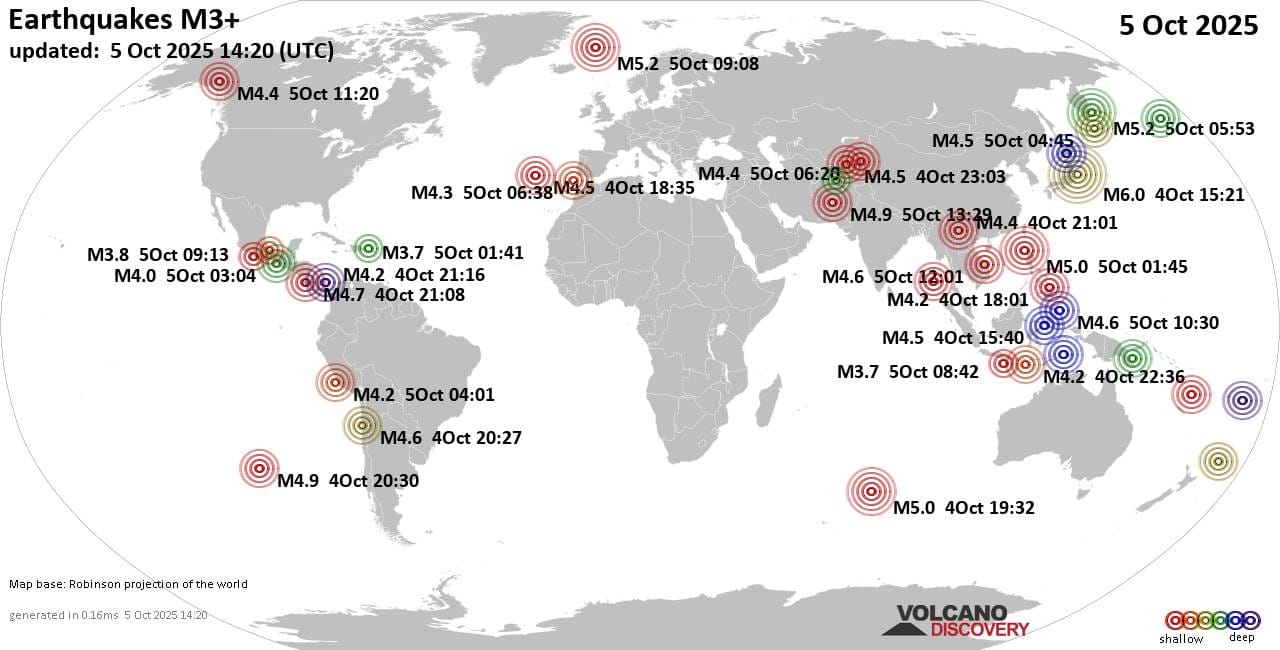
Worldwide earthquakes above magnitude 3 during the past 24 hours on 5 Oct 2025

Summary: 1 quake 6.0+, 7 quakes 5.0+, 63 quakes 4.0+, 168 quakes 3.0+, 429 quakes 2.0+ (668 total)
This report is being updated every hour.
Magnitude 6+: 1 earthquake
Magnitude 5+: 7 earthquakes
Magnitude 4+: 63 earthquakes
Magnitude 3+: 168 earthquakes
Magnitude 2+: 429 earthquakes
No quakes of magnitude 7 or higherTotal seismic energy estimate: 1.1 x 10¹⁴ joules (29.2 gigawatt hours, equivalent to 25133 tons of TNT or 1.6 atomic bombs!) | equivalent to ONE quake of magnitude 6.1 learn more10 largest earthquakes in the world (past 24 hours)#1: Mag 6.0 Fukushima, 262 km northeast of Takasaki, Gunma, JapanSunday, Oct 5, 2025, at 12:21 am (GMT +9) – #2: Mag 5.2 Norwegian Sea, 30 km northeast of Svalbard Island, Svalbard and Jan MayenSunday, Oct 5, 2025, at 11:08 am (GMT +2) – #3: Mag 5.2 83 km east of Petropavlovsk-Kamchatskiy, Kamchatka, RussiaSunday, Oct 5, 2025, at 05:53 pm (GMT +12) – #4: Mag 5.2 North Pacific Ocean, 184 km southeast of Petropavlovsk-Kamchatskiy, Kamchatka, RussiaSunday, Oct 5, 2025, at 04:38 am (GMT +11) – #5: Mag 5.1 North Pacific Ocean, 122 km southeast of Ostrov Onekotan Island, Sakhalin Oblast, RussiaSunday, Oct 5, 2025, at 12:34 pm (GMT +11) – #6: Mag 5.0 North Pacific Ocean, 153 km southeast of

Click this link to continue reading the article on the source website.

RSS feed source: Volcano Discovery.com--Global earthquake monitor

Date and TimeMag
DepthDistanceLocationDetailsMap Oct 4, 01:36 pm (Mexico City)

3.7

2.3 km85 km (53 mi) to the SE North Pacific Ocean, 47 km southwest of Crucecita, Estado de Oaxaca, MexicoI FELT IT

Info

Oct 4, 01:34 pm (Mexico City)

3.7

2 km79 km (49 mi) to the SE North Pacific Ocean, 51 km southwest of Crucecita, Estado de Oaxaca, MexicoI FELT IT

Info

Oct 2, 04:30 pm (Mexico City)

3.1

13 km32 km (20 mi) to the S 13 km southeast of Puerto Escondido, Estado de Oaxaca, MexicoI FELT IT1 report

Info

Sep 30, 04:49 am (Mexico City)

3.8

2 km65 km (40 mi) to the NW 68 km east of Pinotepa Nacional, Estado de Oaxaca, MexicoI FELT IT1 report

Info

Sep 29, 03:10 am (Mexico City)

3.8

14 km61 km (38 mi) to the SW North Pacific Ocean, 53 km west of Puerto Escondido, Estado de Oaxaca, MexicoI FELT IT

Info

Apr 3, 2023 08:11 pm (Mexico City)

5.4

31 km6.7 km (4.2 mi) to the E Near Mexico, Ciudad de México, Mexico 149 reportsInfoJun 23, 2020 08:33 pm (Mexico City)

5.3

17 km97 km (61 mi) to the E 3 km east of San Miguel del Puerto, Estado de Oaxaca, Mexico 8 reportsInfoJun 23, 2020 03:29 pm (Universal Time)

7.1

10 km142 km (88 mi) to the E near Magnitude 7.1, Near of Oaxaca 469 reportsInfoFeb 19, 2018 12:56 am (Mexico City)

5.9

22 km77 km (48 mi) to the W 35 km east of Pinotepa Nacional, Estado de Oaxaca, Mexico 134 reportsInfoFeb 16, 2018 05:39 pm (Mexico City)

7.2

22 km105 km (65 mi) to the W

Click this link to continue reading the article on the source website.

RSS feed source: Volcano Discovery.com--Global earthquake monitor

* WHAT…For the High Rip Current Risk, dangerous rip currents. For the Coastal Flood Advisory, up to one half foot of inundation above ground level expected along shorelines and tidal waterways (9.5 to 9.7 feet Mean Lower Low Water at Fort Pulaski). * WHERE…In Georgia, Coastal Bryan, Coastal Chatham, Coastal Liberty and Coastal McIntosh Counties. In South Carolina, Beaufort and Coastal Jasper Counties. * WHEN…For the High Rip Current Risk, until 8 PM EDT this evening. For the Coastal Flood Advisory, from 5 PM this afternoon to 10 PM EDT this evening. * IMPACTS…Saltwater inundation will impact some roads. Rip currents can sweep even the best swimmers away from shore into

Click this link to continue reading the article on the source website.