RSS feed source: USGS Earthquake Hazards Program
Time2025-09-18 14:59:33 UTC2025-09-18 14:59:33 UTC at epicenterLocation10.181°S 113.897°EDepth10.00 km (6.21 mi)
Click this link to continue reading the article on the source website.
RSS feed source: USGS Earthquake Hazards Program
Time2025-09-18 14:59:33 UTC2025-09-18 14:59:33 UTC at epicenterLocation10.181°S 113.897°EDepth10.00 km (6.21 mi)
Click this link to continue reading the article on the source website.
RSS feed source: USGS Earthquake Hazards Program
From 18/09/2025 to 18/09/2025, a Tropical Depression (maximum wind speed of 148 km/h) NEOGURI-25 was active in NWPacific. The cyclone affects these countries: [unknown] (vulnerability [unknown]). Estimated population affected by category 1 (120 km/h) wind speeds or higher is 0 (0 in tropical storm).
Click this link to continue reading the article on the source website.
RSS feed source: USGS Earthquake Hazards Program
Date and TimeMag
DepthDistanceLocationDetailsMap Sep 16, 05:33 pm (GMT +8)
4.0
10 km13 km (8 mi) to the E Indian Ocean, 204 km southwest of Denpasar, Indonesia I FELT IT – 1 reportInfoSep 6, 12:29 am (GMT +8)
4.8
10 km49 km (31 mi) to the NW Indian Ocean, 149 km south of Gambiran Satu, Indonesia 10 reportsInfoJul 23, 01:00 pm (GMT +8)
4.4
10 km99 km (62 mi) to the SW South of Java, Indonesia InfoJul 18, 08:48 am (GMT +8)
4.3
12 km60 km (37 mi) to the NE Indian Ocean, 150 km southwest of Denpasar, Indonesia InfoJul 14, 08:46 pm (GMT +8)
4.1
10 km71 km (44 mi) to the NE South of Bali, Indonesia 1 reportInfoMay 3, 09:19 am (GMT +7)
4.8
10 km63 km (39 mi) to the N Indian Ocean, 128 km south of Genteng, Indonesia 4 reportsInfoApr 18, 10:13 am (GMT +8)
4.8
10 km49 km (30 mi) to the N Indian Ocean, 143 km south of Genteng, Indonesia 3 reportsInfoAug 14, 2024 09:14 pm (GMT +7)
4.9
51 km68 km (42 mi) to the N Indian Ocean, 123 km south of Genteng, Indonesia 94 reportsInfoMar 1, 2024 04:19 am (GMT +8)
5.0
10 km55 km (34 mi) to the SW South of Java, Indonesia 2 reportsInfoDec 6, 2022 02:07 pm (GMT +8)
6.2
10 km94 km (58 mi) to the SW Indian Ocean, 283 km south of Jember, Kabupaten Jember, Jawa Timur, Indonesia 77 reportsInfoSep 16, 2012 12:32 am (GMT +8)
5.7
10 km74 km (46 mi) to the S Indian Ocean, 275 km southwest of Denpasar, Indonesia InfoSep 4, 2012 02:23 am (GMT +8)
6.1
14 km70 km (44 mi) to the S Indian
Click this link to continue reading the article on the source website.
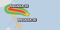
RSS feed source: USGS Earthquake Hazards Program
From 18/09/2025 to 18/09/2025, a Tropical Depression (maximum wind speed of 213 km/h) RAGASA-25 was active in NWPacific. The cyclone affects these countries: Philippines (vulnerability Medium). Estimated population affected by category 1 (120 km/h) wind speeds or higher is 24461 .
Click this link to continue reading the article on the source website.