RSS feed source: USGS Earthquake Hazards Program
Time2026-01-01 03:05:26 UTC2026-01-01 03:05:26 UTC at epicenterLocation6.532°S 129.901°EDepth176.06 km (109.40 mi)
Click this link to continue reading the article on the source website.
RSS feed source: USGS Earthquake Hazards Program
Time2026-01-01 03:05:26 UTC2026-01-01 03:05:26 UTC at epicenterLocation6.532°S 129.901°EDepth176.06 km (109.40 mi)
Click this link to continue reading the article on the source website.
RSS feed source: USGS Earthquake Hazards Program
Time2026-01-01 02:56:21 UTC2026-01-01 02:56:21 UTC at epicenterLocation4.992°N 127.454°EDepth112.00 km (69.59 mi)
Click this link to continue reading the article on the source website.
RSS feed source: USGS Earthquake Hazards Program
On 1/1/2026 1:53:01 AM, an earthquake occurred in Southeast Indian Ridge potentially affecting [unknown]. The earthquake had Magnitude 6M, Depth:10km.
Click this link to continue reading the article on the source website.
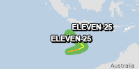
RSS feed source: USGS Earthquake Hazards Program
From 31/12/2025 to 31/12/2025, a Tropical Storm (maximum wind speed of 83 km/h) ELEVEN-25 was active in SEIndian. The cyclone affects these countries: Christmas Island (vulnerability Low). Estimated population affected by category 1 (120 km/h) wind speeds or higher is 0 (0 in tropical storm).
Click this link to continue reading the article on the source website.
![Green earthquake (Magnitude 6M, Depth:10km) in Southeast Indian Ridge 01/01/2026 01:53 UTC, [unknown].](https://resilienceengineeringinstitute.org/wp-content/uploads/2025/12/eq1680050_1.png)