RSS feed source: Volcano Discovery.com--Global earthquake monitor

Thursday, Dec 4, 2025 14:20 | 10 mins ago | By: EarthquakeMonitor

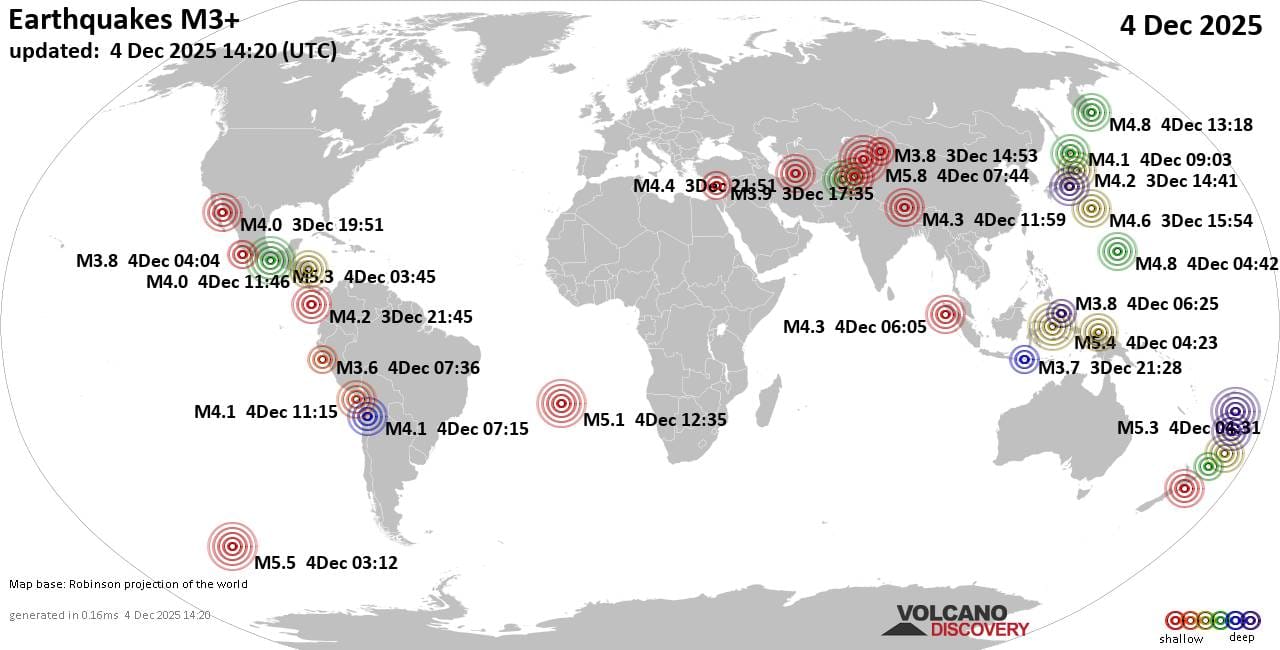
Worldwide earthquakes above magnitude 3 during the past 24 hours on 4 Dec 2025

Summary: 8 quakes 5.0+, 45 quakes 4.0+, 159 quakes 3.0+, 272 quakes 2.0+ (484 total)
This report is being updated every hour.
Magnitude 5+: 8 earthquakes
Magnitude 4+: 45 earthquakes
Magnitude 3+: 159 earthquakes
Magnitude 2+: 272 earthquakes
No quakes of magnitude 6 or higherTotal seismic energy estimate: 8.7 x 10¹³ joules (24.1 gigawatt hours, equivalent to 20696 tons of TNT or 1.3 atomic bombs!) | equivalent to ONE quake of magnitude 6.1 learn more10 largest earthquakes in the world (past 24 hours)#1: Mag 5.8 Xinjiang, ChinaThursday, Dec 4, 2025, at 01:44 pm (Urumqi time) – #2: Mag 5.5 Pacific-Antarctic RidgeWednesday, Dec 3, 2025, at 06:12 pm (GMT -9) – #3: Mag 5.4 Maluku Sea, 152 km west of Pulau Latalata Island, North Maluku, IndonesiaThursday, Dec 4, 2025, at 01:23 pm (GMT +9) – #4: Mag 5.3 23 km west of Salina Cruz, Estado de Oaxaca, MexicoWednesday, Dec 3, 2025, at 09:45 pm (Mexico City time) – #5: Mag 5.3 South Pacific Ocean, 276 km southeast of Matuku Island, Eastern, FijiThursday, Dec 4, 2025, at 04:31 pm (GMT +12) – #6: Mag 5.1 Pacific-Antarctic RidgeWednesday, Dec 3, 2025, at 06:14 pm (GMT -9) – #7: Mag 5.1 Southern Mid-Atlantic RidgeThursday, Dec 4,

Click this link to continue reading the article on the source website.

RSS feed source: Volcano Discovery.com--Global earthquake monitor

Thursday, Dec 4, 2025 14:19 | 10 mins ago | By: EarthquakeMonitor

A magnitude 4.5 earthquake near Tiakur, Southwest Maluku Regency, Maluku, Indonesia, was reported only 19 minutes ago by Indonesia’s Meteorology, Climatology, and Geophysical Agency, considered the main national agency that monitors seismic activity in Indonesia. The earthquake occurred at a great depth of 306. km beneath the epicenter late at night on Thursday, December 4th, 2025, at 10:58 pm local time. The exact magnitude, epicenter, and depth of the quake might be revised within the next few hours or minutes as seismologists review data and refine their calculations, or as other agencies issue their report.
Our monitoring service identified a second report from the citizen-seismograph network of RaspberryShake which listed the quake at magnitude 4.5 as well.
According to preliminary calculations, we do not expect that the quake was felt by many people and did not cause any damage. In Tiakur (pop. 5,200, 111 km away), the quake was probably not felt.
VolcanoDiscovery will automatically update magnitude and depth if these change and follow up if other significant news about the quake become available. If you’re in the area, please send us your experience through our reporting mechanism, either online or via our mobile app. This will help us provide more first-hand updates to anyone around the globe who wants to know

Click this link to continue reading the article on the source website.

RSS feed source: Volcano Discovery.com--Global earthquake monitor

Thursday, Dec 4, 2025 06:00 | By: VN

Sakurajima (Kyushu, Japan): Explosive activity continues. Volcanic Ash Advisory Center (VAAC) Tokyo warned about a volcanic ash plume that rose up to estimated 6000 ft (1800 m) altitude or flight level 060 .
The full report is as follows: ERUPTED AT 20251203/2342Z FL060 EXTD SE OBS VA DTG:04/0010Z to 6000 ft (1800 m)

Ibu (Halmahera, Indonesia): Volcanic Ash Advisory Center Darwin (VAAC) issued the following report: VA REPORTED TO FL070 MOV NE AT 04/0240Z EST VA DTG:04/0330Z

Semeru (East Java, Indonesia): Volcanic Ash Advisory Center Darwin (VAAC) issued the following report: VA ERUPTION LAST REPORTED AT 03/1829Z EST VA DTG:03/2150Z

Aoba (Vanuatu): Explosive activity continues. Volcanic Ash Advisory Center (VAAC) Wellington warned about a volcanic ash plume that rose up to estimated 8000 ft (2400 m) altitude or flight level 080 and is moving at 10 kts in NW direction.
The

Click this link to continue reading the article on the source website.

RSS feed source: Volcano Discovery.com--Global earthquake monitor

Date and TimeMag
DepthDistanceLocationDetailsMap Dec 2, 09:30 pm (GMT +9)

4.7

129 km87 km (54 mi) to the NW Banda Sea, 65 km north of Pulau Lakor Island, Maluku, IndonesiaI FELT IT InfoNov 28, 01:42 pm (GMT +9)

4.3

192 km90 km (56 mi) to the N Banda Sea, 34 km south of Pulau Damar Island, Maluku, IndonesiaI FELT IT InfoNov 28, 09:43 am (GMT +9)

4.4

99 km62 km (38 mi) to the N Banda Sea, 63 km south of Pulau Damar Island, Maluku, IndonesiaI FELT IT InfoNov 25, 03:43 am (GMT +9)

4.4

94 km67 km (41 mi) to the NW Banda Sea, 54 km northeast of Pulau Lakor Island, Maluku, Indonesia InfoNov 7, 01:50 am (Jayapura)

4.1

115 km77 km (48 mi) to the N Banda Sea, 48 km south of Pulau Damar Island, Maluku, Indonesia InfoNov 3, 07:59 am (Jayapura)

4.7

10 km22 km (14 mi) to the N Banda Sea, 26 km northwest of Pulau Sermata Island, Maluku, Indonesia InfoOct 10, 05:21 am (GMT +9)

4.6

115 km78 km (48 mi) to the NW Banda Sea InfoSep 27, 11:02 pm (GMT +9)

4.5

181 km97 km (60 mi) to the NW Banda Sea, 73 km north of Pulau Lakor Island, Maluku, Indonesia InfoSep 18, 12:52 am (GMT +9)

4.5

10 km64 km (40 mi) to the NE Banda Sea, 56 km west of Pulau Wetan Island, Maluku, Indonesia InfoApr 1, 07:15 pm (GMT +9)

5.7

141 km75 km (46 mi) to the N Banda Sea, 109 km west of Pulau Wetan Island, Maluku, Indonesia 16 reportsInfoMar 12, 09:51 pm (GMT +9)

5.2

134 km90 km (56 mi) to the NE

Click this link to continue reading the article on the source website.