RSS feed source: US National Weather Service
Monitoring message only. Please disregard.
Click this link to continue reading the article on the source website.
RSS feed source: US National Weather Service
Monitoring message only. Please disregard.
Click this link to continue reading the article on the source website.
RSS feed source: US National Weather Service
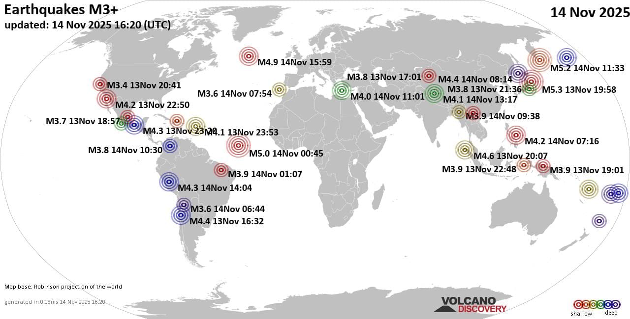
Friday, Nov 14, 2025 16:20 | 7 mins ago | By: EarthquakeMonitor
Worldwide earthquakes above magnitude 3 during the past 24 hours on 14 Nov 2025
Summary: 3 quakes 5.0+, 30 quakes 4.0+, 155 quakes 3.0+, 351 quakes 2.0+ (539 total)
This report is being updated every hour.
Magnitude 5+: 3 earthquakes
Magnitude 4+: 30 earthquakes
Magnitude 3+: 155 earthquakes
Magnitude 2+: 351 earthquakes
No quakes of magnitude 6 or higherTotal seismic energy estimate: 2.2 x 10¹³ joules (6.24 gigawatt hours, equivalent to 5368 tons of TNT or 0.3 atomic bombs!) | equivalent to ONE quake of magnitude 5.7 learn more10 largest earthquakes in the world (past 24 hours)#1: Mag 5.3 North Pacific Ocean, 212 km east of Morioka, Iwate, JapanFriday, Nov 14, 2025, at 05:58 am (GMT +10) – #2: Mag 5.2 North Pacific Ocean, 132 km east of Ostrov Shumshu Island, Kamchatka, RussiaFriday, Nov 14, 2025, at 10:33 pm (GMT +11) – #3: Mag 5.0 Central Mid-Atlantic RidgeThursday, Nov 13, 2025, at 10:45 pm (GMT -2) – #4: Mag 4.9 Reykjanes RidgeFriday, Nov 14, 2025, at 01:59 pm (GMT -2) – #5: Mag 4.9 Coral Sea, 33 km northwest of Maewo Island, Penama Province, VanuatuFriday, Nov 14, 2025, at 11:10 pm (Efate time) – #6: Mag 4.7 North Pacific Ocean, 55 km east of Ostrov Shumshu Island, Kamchatka, RussiaFriday, Nov 14, 2025, at 07:38 pm (GMT
Click this link to continue reading the article on the source website.
RSS feed source: US National Weather Service
Time2025-11-14 15:59:04 UTC2025-11-14 15:59:04 UTC at epicenterLocation52.683°N 34.839°WDepth10.00 km (6.21 mi)
Click this link to continue reading the article on the source website.
RSS feed source: US National Weather Service
* WHAT…Flooding caused by excessive rainfall is expected. * WHERE…Western Los Angeles County * WHEN…Until noon PST. * IMPACTS…Minor flooding in low-lying and poor drainage areas. Water over roadways. * ADDITIONAL DETAILS… – At 814 AM PST, Doppler radar indicated heavy rain. Minor flooding is ongoing or expected to begin shortly in the advisory area. Between 0.3 and 0.6 inches of rain have fallen. – Some locations that will experience flooding include… Thousand Oaks, Malibu, Santa Clarita, Chatsworth, Northridge, Woodland Hills, Van Nuys, Encino, Agoura Hills, Santa Monica, Porter Ranch, Granada Hills, Sylmar, Canoga Park, Calabasas, Lake Hughes, Elizabeth Lake, Topanga State Park and Malibu Creek State Park. – http://www.weather.gov/safety/flood
Click this link to continue reading the article on the source website.