RSS feed source: USGS Earthquake Hazards Program
Time2025-11-05 01:48:31 UTC2025-11-05 01:48:31 UTC at epicenterLocation35.338°S 105.870°WDepth10.00 km (6.21 mi)
Click this link to continue reading the article on the source website.
RSS feed source: USGS Earthquake Hazards Program
Time2025-11-05 01:48:31 UTC2025-11-05 01:48:31 UTC at epicenterLocation35.338°S 105.870°WDepth10.00 km (6.21 mi)
Click this link to continue reading the article on the source website.
RSS feed source: USGS Earthquake Hazards Program
Support Us – Help Us Enhance Our Services! We’re passionate about delivering the latest volcano and earthquake data from around the globe — just for you. However, maintaining our website and free apps requires significant time, effort, and resources.
Your support helps us expand our hardware and software capabilities and empowers our dedicated editorial team. Our mission is to provide uninterrupted, real-time updates whenever an earthquake strikes or a volcano erupts — and your donations make this possible. Every contribution, big or small, is deeply appreciated. If you find our information valuable and want to help us add new features, create compelling content, and improve our technology, please consider making a donation: Donate with PayPal: Planned Features: Improved multilingual support Tsunami alerts Faster responsiveness Thanks to your past donations, we have recently added: Design upgrades Detailed earthquake statistics Additional seismic data sources Download the Volcanoes & Earthquakes app to stay among the first to receive the fastest seismic and volcano alerts online:
Android | iOS
Thank you for being part of our mission!
Click this link to continue reading the article on the source website.
RSS feed source: USGS Earthquake Hazards Program
Wed, 5 Nov 2025, 01:50 | BY: EARTHQUAKEMONITOR
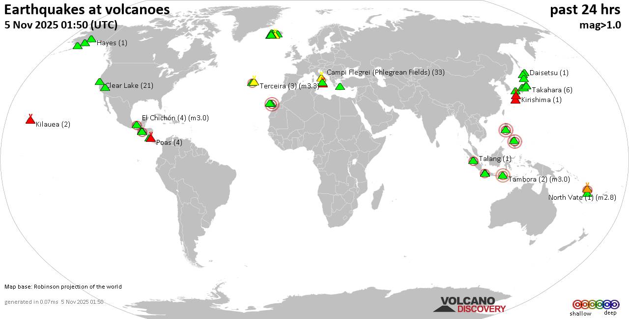
World map showing volcanoes with shallow (less than 50 km) earthquakes within 20 km radius during the past 24 hours on 5 Nov 2025 Number in brackets indicate nr of quakes.
Quakes detected near: Abu (2 quakes between mag 0.8-1.2), Aoba (1 quake mag 2.0), Apaneca Range (62 quakes between mag 1.5-3.2), Augustine (1 quake mag 1.7), Brennisteinsfjöll (4 quakes between mag 0.7-1.5), Campi Flegrei (Phlegrean Fields) (33 quakes between mag 0.1-2.4)
Cerro Singüil (1 quake mag 2.4), Clear Lake (21 quakes between mag 0.6-1.9), Coso (4 quakes between mag 1.0-1.3), Daisetsu (1 quake mag 1.3), El Chichón (4 quakes between mag 2.3-3.0), Eldey (4 quakes between mag 1.1-2.6), Etna (1 quake mag 1.1), Gran Canaria (4 quakes between mag 0.5-3.0), Haku-san (3 quakes between mag 0.4-1.0), Hayes (1 quake mag 1.1), Hekla (3 quakes between mag 0.1-1.1), Hibok-Hibok (1 quake mag 3.0), Hofsjökull (1 quake mag 1.4), Iwaki (2 quakes between mag 0.7-1.4), Izalco (3 quakes between mag 2.2-2.6), Katla (2 quakes between mag 1.0-1.2), Kawah Kamojang (1 quake mag 2.3), Kilauea (2 quakes between mag 1.2-1.8), Kirishima (1 quake mag 1.1), Kolumbo (16 quakes between mag 0.5-2.9), Krísuvík (5 quakes between mag 0.4-1.2), Lipari (2 quakes between mag 1.9-2.2), Ljósufjöll (9 quakes between mag 0.4-1.2), Loki-Fögrufjöll volcano (1 quake mag 1.7), Nantai (6 quakes
Click this link to continue reading the article on the source website.
RSS feed source: USGS Earthquake Hazards Program
Date and TimeMag
DepthDistanceLocationDetailsMap Nov 5, 12:33 am (Universal Time)
5.0
10 km8.1 km (5 mi) to the N Southern East Pacific Rise I FELT IT InfoAug 31, 06:10 am (GMT -7)
4.7
10 km61 km (38 mi) to the E Southern East Pacific Rise InfoMay 16, 12:15 pm (GMT -7)
4.9
10 km26 km (16 mi) to the SE Southern East Pacific Rise InfoApr 23, 09:25 am (GMT -7)
4.9
10 km53 km (33 mi) to the E Southern East Pacific Rise InfoJan 17, 06:59 am (GMT -7)
4.3
10 km70 km (44 mi) to the WSouthern East Pacific Rise InfoDec 9, 2024 07:00 am (GMT -7)
5.0
10 km36 km (22 mi) to the SW Southern East Pacific Rise InfoMar 30, 2021 02:35 pm (GMT -7)
5.3
10 km10.7 km (6.7 mi) to the W Southern East Pacific Rise InfoJan 10, 2021 08:44 am (GMT -7)
5.4
10 km7.1 km (4.4 mi) to the SW Southern East Pacific Rise InfoDec 26, 2015 04:48 pm (GMT -7)
5.0
10 km13 km (8 mi) to the SW Southern East Pacific Rise InfoJul 20, 2015 04:08 am (GMT -7)
5.7
10 km72 km (45 mi) to the E Southern East Pacific Rise InfoJun 8, 2015 11:41 pm (GMT -7)
5.5
10 km12 km (7.3 mi) to the NW Southern East Pacific Rise InfoJan 18, 2015 04:13 pm (GMT -7)
5.7
8.3 km17 km (10.3 mi) to the SE Southern East Pacific Rise InfoOct 31, 2011 12:14 pm (GMT -7)
5.1
10 km73 km (45 mi) to the E Southern East Pacific Rise InfoJun 12, 2010 02:05 am (GMT -7)
5.3
10 km46 km (29 mi) to the W Southern East Pacific Rise InfoApr 12, 2010 05:36 am (GMT -7)
5.3
10 km44 km (27 mi) to the SE Southern
Click this link to continue reading the article on the source website.