RSS feed source: US National Weather Service

* WHAT…Subfreezing temperatures around 30 degrees. * WHERE…A portion of northern Indiana. * WHEN…Until 9 AM EDT this morning. * IMPACTS…Frost and freeze conditions could kill crops, other sensitive vegetation and possibly damage unprotected outdoor plumbing.

Click this link to continue reading the article on the source website.

RSS feed source: US National Weather Service

Date and TimeMag
DepthDistanceLocationDetailsMap Oct 23, 12:31 pm (Mexico City)

4.0

127 km56 km (35 mi) to the SW 79 km south of Acayucan, Estado de Veracruz-Llave, MexicoI FELT IT InfoOct 21, 02:37 pm (Mexico City)

4.0

111 km99 km (61 mi) to the SW 60 km northwest of Matias Romero, Estado de Oaxaca, MexicoI FELT IT InfoOct 17, 05:01 pm (Mexico City)

4.1

130 km86 km (53 mi) to the SE Estado de Oaxaca, 66 km northwest of Cintalapa de Figueroa, MexicoI FELT IT InfoOct 14, 09:47 pm (Mexico City)

4.0

173 km76 km (47 mi) to the SE Veracruz, Mexico InfoOct 14, 07:14 pm (Mexico City)

4.0

149 km9.1 km (5.6 mi) to the W Veracruz, Mexico InfoOct 11, 08:26 pm (Mexico City)

4.8

159 km36 km (22 mi) to the SE 14 km E of Niños Héroes, Mexico 6 reportsInfoSep 25, 03:11 pm (Mexico City)

4.7

181 km37 km (23 mi) to the E 25 km SSE of Cuichapa, Mexico 1 reportInfoSep 22, 11:01 am (Mexico City)

4.2

148 km93 km (58 mi) to the SE Estado de Oaxaca, 51 km northwest of Cintalapa de Figueroa, Mexico 1 reportInfoSep 21, 01:13 pm (Mexico City)

4.1

129 km60 km (38 mi) to the SW Estado de Veracruz-Llave, 42 km northeast of Matias Romero, Mexico InfoOct 6, 2023 11:06 pm (Mexico City)

6.0

110 km99 km (61 mi) to the SW 12 km northwest of Matias Romero, Estado de Oaxaca, Mexico 127 reportsInfoMar 15, 2021 11:54 am (Mexico City)

5.3

190 km52 km (32 mi) to the E 34 km south of Las Choapas, Estado de Veracruz-Llave, Mexico InfoDec 17, 2020 07:06 pm (Mexico

Click this link to continue reading the article on the source website.

RSS feed source: US National Weather Service

Fri, 24 Oct 2025, 09:50 | BY: EARTHQUAKEMONITOR

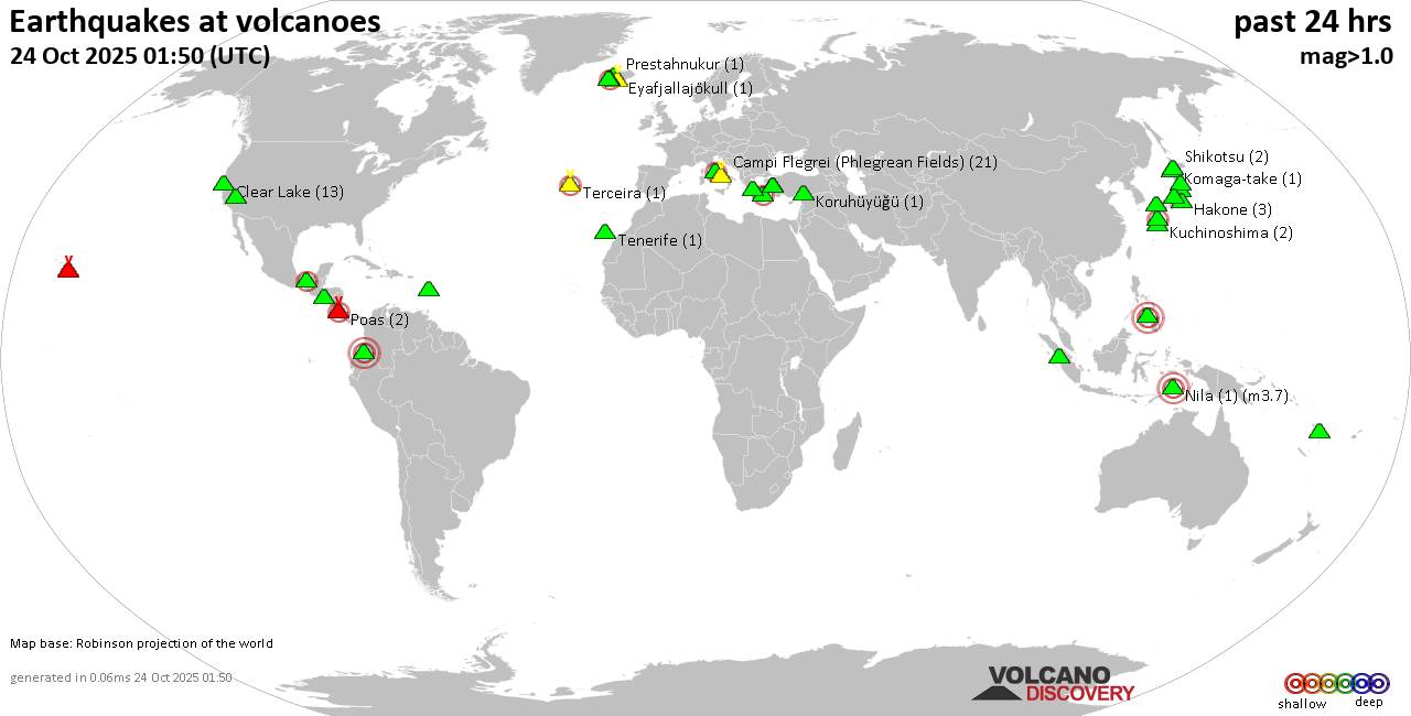
World map showing volcanoes with shallow (less than 50 km) earthquakes within 20 km radius during the past 24 hours on 24 Oct 2025 Number in brackets indicate nr of quakes.

Quakes detected near: Abu (22 quakes between mag 0.1-1.3), Akita-Yake-yama (1 quake mag 1.1), Akuseki-jima (1 quake mag 3.1), Bandai (2 quakes between mag 0.3-1.3), Bardarbunga (6 quakes between mag 0.2-2.0), Barva (1 quake mag 3.0)
Brennisteinsfjöll (4 quakes between mag 0.3-1.0), Campi Flegrei (Phlegrean Fields) (18 quakes between mag 0.1-1.2), Cerro Singüil (1 quake mag 2.0), Clear Lake (25 quakes between mag 0.1-2.0), Coso (1 quake mag 1.5), Cuernos de Negros (1 quake mag 3.0), El Chichón (14 quakes between mag 2.2-3.3), El Hierro (1 quake mag 2.1), Eldey (1 quake mag 1.0), Galeras (1 quake mag 3.0), Gran Canaria (1 quake mag 1.1), Hakone (2 quakes between mag 0.3-1.1), Ibusuku (1 quake mag 2.2), Kaguyak (2 quakes between mag 1.6-1.8), Katla (4 quakes between mag 0.6-1.2), Kilauea (3 quakes between mag 1.5-1.7), Kirishima (2 quakes between mag 0.6-1.4), Kolumbo (4 quakes between mag 1.4-2.0), Komaga-take (1 quake mag 1.0), Koruhüyüğü (1 quake mag 2.0), Kozushima (1 quake mag 1.9), Krísuvík (20 quakes between mag 0.1-1.2), Kuchinoshima (2 quakes between mag 2.1-2.5), Kurikoma (1 quake mag 1.0), Kuwae (1 quake mag 1.7), Laguna Aramuaca

Click this link to continue reading the article on the source website.
RSS feed source: US National Weather Service

Date and TimeMag
DepthDistanceLocationDetailsMap Feb 23, 04:25 am (GMT +12)

4.3

626 km46 km (29 mi) to the W South of Fiji Islands InfoApr 9, 2024 10:45 pm (GMT +12)

4.9

590 km67 km (41 mi) to the SW South of the Fiji Islands InfoFeb 27, 2024 01:49 am (GMT +12)

4.2

611 km42 km (26 mi) to the W South of the Fiji Islands InfoNov 16, 2023 11:55 am (GMT +12)

5.0

610 km64 km (40 mi) to the SW South of the Fiji Islands InfoApr 19, 2023 12:48 pm (GMT +12)

4.0

591 km61 km (38 mi) to the SWSouth of the Fiji Islands InfoApr 18, 2023 04:31 pm (GMT +12)

6.7

580 km67 km (42 mi) to the SW South Pacific Ocean, 477 km south of Suva, Central, Fiji 1 reportInfoJan 13, 2023 04:28 am (GMT +12)

5.5

598 km26 km (16 mi) to the W South of the Fiji Islands InfoSep 29, 2021 07:41 am (GMT +12)

4.8

588 km64 km (40 mi) to the SW South of Fiji Islands InfoJul 15, 2021 11:54 am (GMT +12)

5.1

623 km89 km (55 mi) to the W South of Fiji Islands InfoJul 15, 2021 11:53 am (GMT +12)

5.3

33 km90 km (56 mi) to the N South Pacific Ocean, 363 km southeast of Suva, Central, Fiji InfoSep 26, 2019 01:03 am (GMT +12)

5.2

10 km58 km (36 mi) to the S near Magnitude 5.2, Near of Nouméa InfoFeb 21, 2016 02:38 am (GMT +12)

4.8

570 km83 km (52 mi) to the SW South Pacific Ocean, 481 km south of Suva, Central, Fiji InfoOct 9, 2014 11:34 pm (GMT +12)

5.0

599 km37 km (23 mi) to the SW South of Fiji Islands

Click this link to continue reading the article on the source website.