RSS feed source: US National Weather Service

SVRSJT The National Weather Service in San Angelo has issued a * Severe Thunderstorm Warning for… Southeastern Crockett County in west central Texas… Western Sutton County in west central Texas… * Until 800 PM CDT. * At 713 PM CDT, a severe thunderstorm was located near The Intersection Of Highway 163 And Ranch Road 1973, or 16 miles southeast of Ozona, moving east at 45 mph. HAZARD…Ping pong ball size hail and 60 mph wind gusts. SOURCE…Radar indicated. IMPACT…People and animals outdoors will be injured. Expect hail damage to roofs, siding, windows, and vehicles. Expect wind damage to roofs, siding, and trees. * This severe thunderstorm will be near… Sonora around

Click this link to continue reading the article on the source website.

RSS feed source: US National Weather Service

Sat, 25 Oct 2025, 00:04 | BY: EARTHQUAKEMONITOR

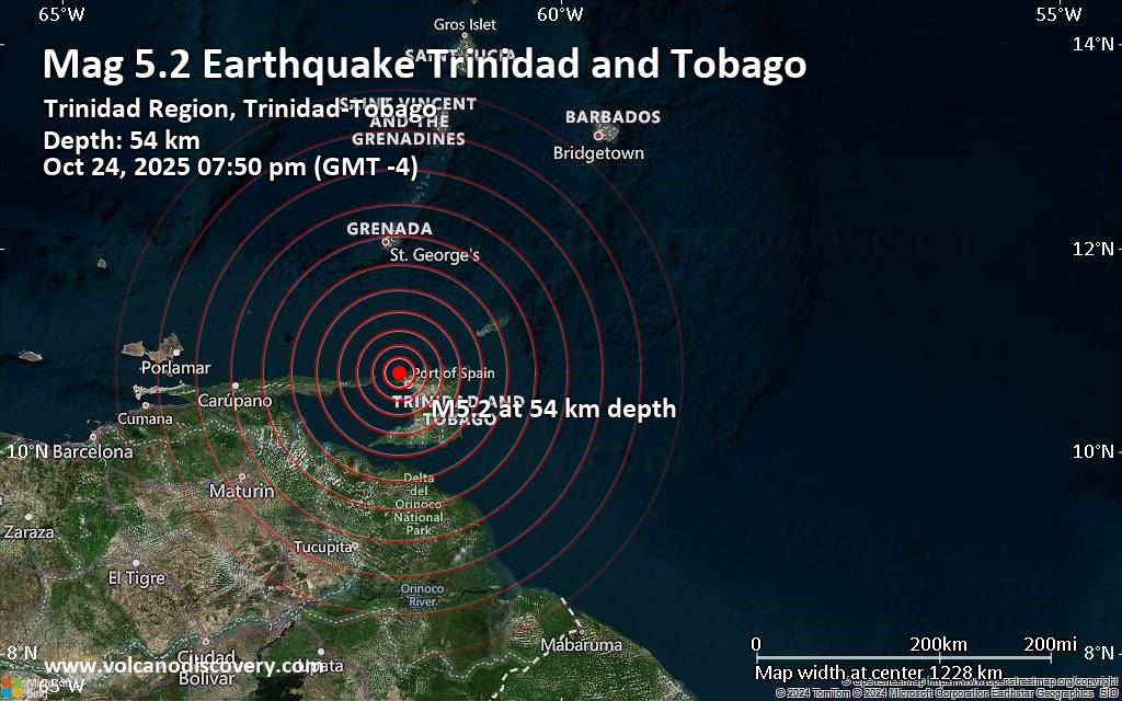
Just 12 minutes ago, a 5.2-magnitude earthquake struck near Port of Spain, City of Port of Spain, Trinidad & Tobago. The tremor was recorded early evening on Friday, October 24th, 2025, at 7:50 pm local time, at a moderately shallow depth of 54. km below the surface.
The event was filed by the European-Mediterranean Seismological Centre (EMSC), the first seismological agency to report it.
Our monitoring service identified a second report from the citizen-seismograph network of RaspberryShake which listed the quake at magnitude 5.2 as well. A third agency, the German Research Centre for Geosciences (GFZ), reported the same quake at magnitude 5.2.
Based on the preliminary seismic data, the quake should not have caused any significant damage, but was probably felt by many people as light vibration in the area of the epicenter.
Weak shaking might have been felt in Petit Valley (pop. 8,100) located 12 km from the epicenter, Port of Spain (pop. 49,000) 17 km away, Laventille (pop. 21,000) 20 km away, Tunapuna (pop. 17,800) 29 km away, Paradise (pop. 15,100) 31 km away, Chaguanas (pop. 67,400) 37 km away, and Mon Repos (pop. 56,400) 59 km away.
VolcanoDiscovery will automatically update magnitude and depth if these change and follow up if other significant news about the quake become available. If you’re in the area,

Click this link to continue reading the article on the source website.
RSS feed source: US National Weather Service

Support Us – Help Us Enhance Our Services! We’re passionate about delivering the latest volcano and earthquake data from around the globe — just for you. However, maintaining our website and free apps requires significant time, effort, and resources.
Your support helps us expand our hardware and software capabilities and empowers our dedicated editorial team. Our mission is to provide uninterrupted, real-time updates whenever an earthquake strikes or a volcano erupts — and your donations make this possible. Every contribution, big or small, is deeply appreciated. If you find our information valuable and want to help us add new features, create compelling content, and improve our technology, please consider making a donation: Donate with PayPal: Planned Features: Improved multilingual support Tsunami alerts Faster responsiveness Thanks to your past donations, we have recently added: Design upgrades Detailed earthquake statistics Additional seismic data sources Download the Volcanoes & Earthquakes app to stay among the first to receive the fastest seismic and volcano alerts online:
Android | iOS

Thank you for being part of our mission!

Click this link to continue reading the article on the source website.
RSS feed source: US National Weather Service

Date and TimeMag
DepthDistanceLocationDetailsMap Sep 17, 06:48 pm (GMT -4)

4.0

26 km173 km (108 mi) to the NE Tobago Region, Trinidad-Tobago InfoJun 16, 09:40 am (GMT -4)

3.9

17 km165 km (103 mi) to the NE Grenada Region, Windward Islands

Info

Dec 19, 2024 09:19 pm (Grenada)

3.5

131 km141 km (88 mi) to the N Caribbean Sea, 27 km south of Saint George’s, Saint George, Grenada 1 report

Info

May 22, 2024 01:38 am (GMT -4)

3.6

10 km241 km (150 mi) to the N Caribbean Sea, 82 km northwest of Saint George’s, Saint George, Grenada

Info

Mar 19, 2024 01:52 pm (GMT -4)

4.5

142 km158 km (98 mi) to the N Caribbean Sea, 32 km west of Saint George’s, Saint George, Grenada 2 reportsInfoMar 14, 2022 04:49 am (GMT -4)

4.3

153 km180 km (112 mi) to the N 43 km W of Saint George’S, Grenada InfoApr 6, 2020 11:26 pm (GMT -4)

5.0

31 km134 km (83 mi) to the NE Windward Islands 35 reportsInfoFeb 27, 2019 01:13 am (GMT -4)

4.5

70 km276 km (172 mi) to the NE Caribbean Sea, 71 km southeast of Kingstown, Saint Vincent and the Grenadines 3 reportsInfoAug 21, 2018 05:31 pm (Caracas)

7.2

121 km128 km (80 mi) to the W Caribbean Sea, 39 km east of Carupano, Sucre, Venezuela 734 reportsInfoDec 20, 2017 12:13 am (GMT -4)

4.6

70 km145 km (90 mi) to the NE Tobago Region, Trinidad-Tobago 3 reportsInfoNov 5, 2017 11:00 am (GMT -4)

5.3

64 km138 km (86 mi) to the N Caribbean Sea, 59 km southeast of Saint George’s, Saint George, Grenada 12 reportsInfoOct 2, 2017 08:08 am (St Vincent)

4.3

136 km305 km (189 mi) to the N

Click this link to continue reading the article on the source website.